
The strongest wind near the storm center is level 10 (89-102km/h), gusting to level 12. Moving in the West Southwest direction, speed about 10km/h.
Forecast until 4am on October 23, Storm in the sea area from Hue city to Quang Ngai , strong wind level 7, gust level 9, moving in the West Southwest direction at a speed of about 15km/h and gradually weakening into a tropical depression. The affected area is the sea area west of the North East Sea (including Hoang Sa special zone), the sea area from Quang Tri to Quang Ngai (including Con Co special zones, Ly Son and Cu Lao Cham island), Natural disaster risk level 3.
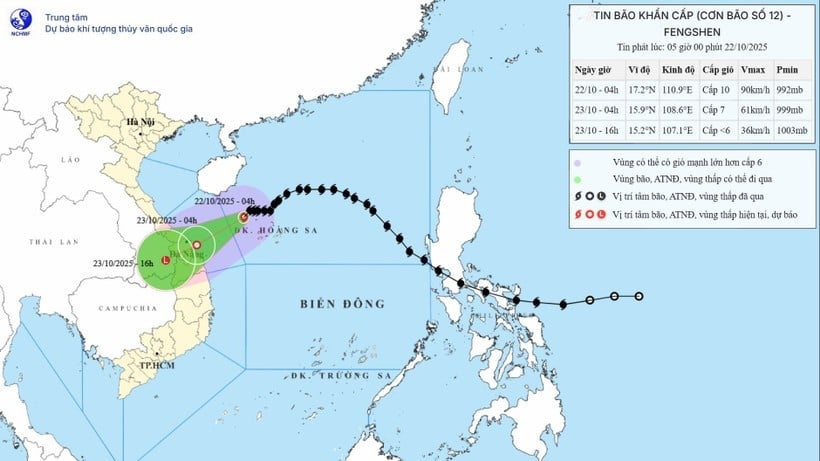
Then, at 4:00 a.m. on October 24, the storm in the Southern Laos area, with winds below level 6, moved in the West Southwest direction at a speed of about 10-15 km/hour and weakened into a low pressure area. The affected area is the sea from Quang Tri to Quang Ngai (including the special zones of Con Co, Ly Son and Cu Lao Cham island), the mainland coastal provinces and cities from Quang Tri to Da Nang .
Due to the impact of the storm, the western sea area of the North East Sea (including Hoang Sa special zone) has strong winds of level 7-8; the area near the storm's eye has strong winds of level 9-10, gusting to level 12; waves 3-5m high, the area near the storm's eye has waves of 5-7m high, very rough seas.
The sea area from Quang Tri to Quang Ngai (including Con Co special zone, Cu Lao Cham island and Ly Son special zone) has strong winds of level 6-7, the area near the storm's eye has winds of level 8, gusts of level 10, waves 3-5m high, rough seas.
Coastal areas from Quang Tri to Da Nang city have storm surges ranging from 0.4 to 0.8 meters high.
Warning: All ships and boats operating in the above-mentioned dangerous areas are likely to be affected by storms, whirlwinds, strong winds, and large waves. Coastal areas and river mouths from Quang Tri to Da Nang city need to be on guard against large waves combined with high tides and wind-induced water surges that can cause flooding in low-lying areas, coastal roads, and coastal landslides.
On land: Due to the influence of storm circulation No. 12 combined with the strong strengthening of cold air, from the afternoon of October 22, on the mainland coastal provinces and cities from Quang Tri to Da Nang, the wind will gradually increase to level 6, sometimes level 7, gusting to level 8-9. Along with that, also due to the influence of storm circulation and cold air combined with East wind disturbances, terrain effects, from noon on October 22 to October 27, the area from Ha Tinh to Quang Ngai will have widespread heavy rain (heavy rain concentrated from the afternoon of October 22 to the end of October 23).
Total rainfall in general: Ha Tinh to Northern Quang Tri and Quang Ngai is about 200-400mm, locally over 500mm; in the area of Southern Quang Tri to Da Nang city, it is generally 500-700mm, locally over 900mm. Warning of heavy rain over 200mm/3 hours.
Heavy rains in the Central region are likely to last until the end of October 2025. There is a high risk of flash floods and landslides in mountainous areas, and flooding in low-lying and urban areas.
From noon on October 22 to the night of October 23, the area from Ha Tinh to Quang Ngai will have heavy rain and thunderstorms with common rainfall of 100-250mm, locally very heavy rain over 350mm; the area from South Quang Tri to Da Nang city will have heavy to very heavy rain with common rainfall of 250-450mm, locally over 700mm.
Warning of risk of heavy rain over 200mm/3 hours.
In addition, on the morning of October 22, the area from Ha Tinh to Da Nang will have scattered showers and thunderstorms with rainfall ranging from 10-30mm, with some places experiencing heavy rain over 70mm. On the afternoon and evening of October 22, the area from Dak Lak to Lam Dong and the South will have scattered showers and thunderstorms with rainfall ranging from 15-30mm, with some places experiencing heavy rain over 80mm. During the thunderstorms, there is a possibility of tornadoes, lightning, hail and strong gusts of wind.
Warning of risk of heavy rain over 60mm/3 hours.
During the day and night of October 24, the area from Ha Tinh to Quang Ngai will have moderate rain, heavy rain and thunderstorms, locally very heavy rain with rainfall ranging from 40-80mm, locally over 150mm. Heavy rain in this area is likely to last until the end of October 2025.
Level of natural disaster risk due to heavy rain, tornadoes, lightning, hail: Level 1; area from South Quang Tri to Da Nang city level 2.
During the day and night of October 22, cold air continues to affect other places in the Central Central region. Inland, strong northeast winds of level 3, coastal areas of level 4, some places of level 5; coastal provinces from Quang Tri to Da Nang city, due to the influence of storm circulation No. 12 combined with strong cold air, from the afternoon of October 22, winds will gradually increase to level 6, sometimes level 7, gusting to level 8-9.
Source: https://baolangson.vn/bao-so-12-cach-thanh-pho-da-nang-khoang-310km-5062567.html


![[Photo] Da Nang residents "hunt for photos" of big waves at the mouth of the Han River](https://vphoto.vietnam.vn/thumb/1200x675/vietnam/resource/IMAGE/2025/10/21/1761043632309_ndo_br_11-jpg.webp)
![[Photo] Prime Minister Pham Minh Chinh received Mr. Yamamoto Ichita, Governor of Gunma Province (Japan)](https://vphoto.vietnam.vn/thumb/1200x675/vietnam/resource/IMAGE/2025/10/21/1761032833411_dsc-8867-jpg.webp)


Comment (0)