

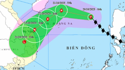
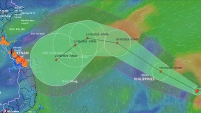
The National Center for Hydro-Meteorological Forecasting said that at 10:00 a.m. on October 20, the center of storm No. 12 Fengshen was about 460 km east-northeast of Hoang Sa special zone. The strongest wind near the center of the storm was level 9 (75-88 km/h), gusting to level 11, moving northwest at a speed of 20-25 km/h.
At around 10am on October 21, storm No. 12 was about 180km north of Hoang Sa special zone, with the possibility of further strengthening. The storm changed direction to the West, moving slowly at a speed of about 15km/h. The strongest wind near the storm's center was at level 11, gusting to level 13.
At 10:00 a.m. on October 22, storm No. 12 Fengshen in the sea northwest of Hoang Sa special zone changed direction to the southwest, moving slowly at a speed of about 10km/h, possibly weakening, intensity still level 9-10, gusting to level 12.
Forecast at 10am on October 23, storm No. 12 Fengshen on the mainland of Da Nang - Quang Ngai city, continues to move in the southwest direction, traveling 10-15km per hour, likely to gradually weaken into a tropical depression with intensity of level 7, gusting to level 9.
From the next 72 to 96 hours, the tropical depression will move mainly in the southwest direction, about 10km per hour and gradually weaken into a low pressure area.
In addition, currently, cold air has a weak impact on the Northeast region of the North. At Bach Long Vi station, there is strong northeast wind at level 6, sometimes level 7, gusting to level 8.
From October 20-22, the cold air will be strengthened, affecting other places in the Northeast and North Central regions, then some places in the Northwest and North Central regions. Inland, the wind will change to the northeast at level 2-3, and in coastal areas at level 3-4.
From the night of October 20, the North and Thanh Hoa will turn cold at night and in the morning, and the mountainous areas will be chilly. The lowest temperature during this cold spell in the Northern Delta and Thanh Hoa is generally 19-21°C, in the mountainous and midland areas of the North 17-19°C, and in some places in the highlands below 16°C.
Hanoi weather is sunny during the day, no rain at night, cold in the morning and at night. The lowest temperature during this cold air wave fluctuates between 19-21°C.
Due to the influence of the storm circulation and cold air combined with easterly wind disturbances, topographic effects and easterly winds after the storm, from October 22-27, Ha Tinh to Quang Ngai is likely to have widespread heavy rain lasting for many days, with some areas having very heavy rain. There is a high risk of flash floods and landslides in mountainous areas, flooding in low-lying areas and urban areas.
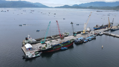
Localities need to pay attention to safely operating hydroelectric and irrigation reservoirs before, during and after the storm, and prepare response plans for flood scenarios on rivers from Quang Tri to Quang Ngai that could reach alert level 3 and exceed alert level 3.
The forecast level of natural disaster risk due to floods and inundations is level 3.
Source: https://quangngaitv.vn/bao-so-12-lien-tuc-doi-huong-nguy-co-gay-lu-vuot-bao-dong-3-o-mien-trung-6508886.html
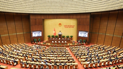
![[Photo] Solemn opening of the 10th Session, 15th National Assembly](https://vphoto.vietnam.vn/thumb/1200x675/vietnam/resource/IMAGE/2025/10/20/1760937111622_ndo_br_1-202-jpg.webp)
![[Photo] National Assembly Chairman Tran Thanh Man holds talks with Hungarian National Assembly Chairman Kover Laszlo](https://vphoto.vietnam.vn/thumb/1200x675/vietnam/resource/IMAGE/2025/10/20/1760952711347_ndo_br_bnd-1603-jpg.webp)

![[Photo] Prime Minister Pham Minh Chinh meets with Speaker of the Hungarian National Assembly Kover Laszlo](https://vphoto.vietnam.vn/thumb/1200x675/vietnam/resource/IMAGE/2025/10/20/1760970413415_dsc-8111-jpg.webp)
![[Photo] Chairman of the Hungarian Parliament visits President Ho Chi Minh's Mausoleum](https://vphoto.vietnam.vn/thumb/1200x675/vietnam/resource/IMAGE/2025/10/20/1760941009023_ndo_br_hungary-jpg.webp)


![[Photo] The Steering Committee of the 2025 Fall Fair checks the progress of the organization](https://vphoto.vietnam.vn/thumb/1200x675/vietnam/resource/IMAGE/2025/10/20/1760918203241_nam-5371-jpg.webp)


Comment (0)