

According to the National Center for Hydro-Meteorological Forecasting, from October 21 to 26, many dangerous weather patterns will occur.
Storm heading towards the northwest sea of Hoang Sa special zone
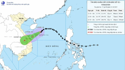
Data from the National Center for Hydro-Meteorological Forecasting shows that storm No. 12 maintains its intensity, but continues to change direction.
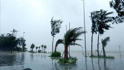
Due to the impact of the storm, the North East Sea has very strong winds and large waves, directly affecting shipping activities. Therefore, measures must be taken to ensure the safety of ships in the above mentioned area.
At 4:00 a.m. on October 21, the center of the storm was at about 18.3 degrees North latitude; 113.0 degrees East longitude, about 200 km northeast of Hoang Sa special zone. The strongest wind near the center of the storm was level 9-10 (75-102 km/h), gusting to level 12. Moving westward at a speed of about 20 km/h.
Forecast until 4:00 a.m. on October 22, the storm in the sea northwest of Hoang Sa special zone, strong wind level 9-10, gust level 12, moving west southwest at a speed of about 10-15 km/h. The affected area is the sea west of the North East Sea (including Hoang Sa special zone). Natural disaster risk level 3.
By 4:00 a.m. on October 23, the storm in the coastal waters of Hue city to Quang Ngai , strong winds of level 6, gusts of level 8, moving southwest at a speed of about 10 km/h and likely to gradually weaken into a tropical depression. The affected area is the western sea area of the North East Sea (including Hoang Sa special zone), the sea area from South Quang Tri to Quang Ngai (including Ly Son special zone). Natural disaster risk level 3.
")
At 4:00 a.m. on October 24, the storm in the Southern Laos area, with winds below level 6, moved southwest at a speed of about 10 km/h and was likely to gradually weaken into a low pressure area.
Due to the impact of the storm, the North East Sea area (including Hoang Sa special zone) has strong winds of level 7-8; the area near the storm's eye has strong winds of level 9-10, gusting to level 12; waves 3-5m high, the area near the storm's eye has waves of 5-7m high, very rough seas.
The sea area from South Quang Tri to Quang Ngai (including Ly Son special zone) has strong winds of level 6, from the morning of October 22 increasing to level 7, the area near the storm center has level 8, gusts of level 10, waves 3-5m high, rough seas.
All ships and boats operating in the above mentioned dangerous areas are susceptible to the impact of storms, whirlwinds, strong winds and large waves.
Heavy rain in the Central region
The National Center for Hydro-Meteorological Forecasting said that on the day and night of October 21, the area from Quang Tri to Da Nang city, the eastern part of the provinces from Quang Ngai to Khanh Hoa and the Southern region will have scattered showers and thunderstorms with rainfall of 15-30mm, locally heavy rain over 80mm (rain in the Southern region will be concentrated in the afternoon and night).
Warning of risk of heavy rain over 60 mm/3 hours.
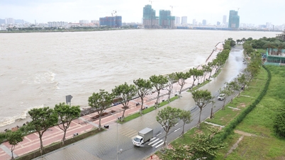
From the night of October 22 to October 26, the area from Ha Tinh to Quang Ngai will have heavy rain, locally very heavy rain with rainfall in the area from South Quang Tri to Da Nang city generally 500-700 mm/period, locally over 900 mm/period; the area from Ha Tinh to North Quang Tri and Quang Ngai will generally 200-400 mm/period, locally over 500 mm/period.
Warning of risk of heavy rain over 200 mm/3 hours.
"Thunderstorm areas are at risk of tornadoes, lightning, hail, and strong gusts of wind. Heavy rain in the Central region is likely to last until the end of October 2025. Warning level of natural disaster risk due to heavy rain, tornadoes, lightning, and hail: level 1, especially in the area from South Quang Tri to Da Nang, level 2," noted Deputy Head of Weather Forecasting Department Vu Anh Tuan.
Heavy rains are likely to cause flooding in low-lying areas, urban and industrial areas; flash floods on small rivers and streams, landslides on steep slopes (real-time warning information on areas at risk of flash floods and landslides is provided online on the website of the Department of Hydrometeorology at: https://luquetsatlo.nchmf.gov.vn and in separate bulletins warning of flash floods and landslides).
Northern and Thanh Hoa mountainous areas have cold weather.
National Center for Hydro-Meteorological Forecasting, on land: on the day and night of October 21, cold air continues to affect some places in the Central Central region and some other places in the Northwest region. Inland, northeast wind level 3, coastal areas level 3-4.
In the Northern region and Thanh Hoa, the weather will turn cold at night and in the morning, and in the mountainous areas it will be chilly. The lowest temperature during this cold spell in the Northern Delta and Thanh Hoa is generally 19-21 degrees Celsius, in the mountainous and midland areas of the North it is 17-19 degrees Celsius, and in the high mountains it is below 16 degrees Celsius in some places.
Hanoi area: no rain at night, sunny during the day. Cold at night and morning. The lowest temperature in this cold air mass is commonly 19-21 degrees Celsius.
At sea, due to the influence of cold air combined with the circulation of storm No. 12, the North East Sea area (including Hoang Sa special zone) has strong northeast winds of level 7-8, the area near the storm's eye has strong winds of level 9-11, gusts of level 13, waves 3-5m high, the area near the storm's eye has waves of 5-7m high, and the sea is very rough.
In the Gulf of Tonkin, there is strong northeast wind at level 6, then increasing to level 7, gusting to level 8-9, rough seas, waves 2-4m high.
In the area from South Quang Tri to Quang Ngai (including Ly Son special zone), the Northeast to North wind is level 6, from the morning of July 22 increasing to level 7, the area near the storm center is level 8-9, gusting to level 11, the sea is very rough, waves are 3-5m high.
Currently, the cold air has weakly affected the North Central region and some places in the Northwest region. At Bach Long Vy station, there is strong Northeast wind at level 6, sometimes level 7, gusting to level 8; Con Co station has strong Northeast wind at level 6.
Weather in regions day and night October 21
Northwest
- Sunny day, no rain at night. Light wind. Cold morning and night, some places are freezing.
- Lowest temperature 18-21 degrees Celsius, some places below 16 degrees Celsius. Highest temperature 28-31 degrees Celsius.
Northeast
- Sunny day, no rain at night. Northeast wind level 3, especially coastal areas level 3-4. Cold morning and night, cold in mountainous areas.
- Lowest temperature 18-21 degrees Celsius, mountainous areas 17-19 degrees Celsius, high mountainous areas in some places below 16 degrees Celsius. Highest temperature 27-30 degrees Celsius.
Hanoi City
- Sunny day, no rain at night. Northeast wind level 3.
- Lowest temperature 20-22 degrees Celsius. Highest temperature 28-30 degrees Celsius.
Provinces and cities from Thanh Hoa to Hue
- In the North, it is cloudy, no rain, in the afternoon the clouds will decrease and the sky will be sunny; in the South (from Ha Tinh to Hue city), there will be scattered rain, showers and thunderstorms, locally heavy rain. North to Northwest wind level 3, coastal areas level 3-4. During thunderstorms, there is a possibility of tornadoes, lightning and strong gusts of wind.
- Lowest temperature 22-25 degrees Celsius. Highest temperature 28-31 degrees Celsius.
South Central Coast
- In the North, there will be scattered showers and thunderstorms, with some heavy rain in some places; in the South, there will be scattered showers and thunderstorms in some places. Northeast wind level 2-3. During thunderstorms, there is a possibility of tornadoes, lightning and strong gusts of wind.
- Lowest temperature 23-26 degrees Celsius. Highest temperature 28-31 degrees Celsius.
Central Highlands
- There will be scattered showers and thunderstorms in some places, especially in the afternoon and evening. Thunderstorms may include tornadoes, lightning, hail and strong gusts of wind.
- Lowest temperature 19-22 degrees Celsius. Highest temperature 27-30 degrees Celsius.
Southern Vietnam
- There will be scattered showers and thunderstorms in some places, especially in the afternoon and evening, with some places having heavy rain. Thunderstorms may bring tornadoes, lightning, hail and strong gusts of wind.
- Lowest temperature 23-26 degrees Celsius. Highest temperature 31-34 degrees Celsius.
Ho Chi Minh City
- There will be scattered showers and thunderstorms in some places, especially in the afternoon and evening, with some places having heavy rain. Thunderstorms may bring tornadoes, lightning, hail and strong gusts of wind.
- Lowest temperature 24-26 degrees Celsius. Highest temperature 32-34 degrees Celsius.
Source: https://baodanang.vn/bao-so-12-tiep-tuc-doi-huong-canh-bao-nhieu-hinh-thai-thoi-tiet-nguy-hiem-mua-lon-o-trung-bo-3306868.html
![[Photo] Prime Minister Pham Minh Chinh meets with Speaker of the Hungarian National Assembly Kover Laszlo](https://vphoto.vietnam.vn/thumb/1200x675/vietnam/resource/IMAGE/2025/10/20/1760970413415_dsc-8111-jpg.webp)
![[Photo] Prime Minister Pham Minh Chinh received Mr. Yamamoto Ichita, Governor of Gunma Province (Japan)](https://vphoto.vietnam.vn/thumb/1200x675/vietnam/resource/IMAGE/2025/10/21/1761032833411_dsc-8867-jpg.webp)


![[Photo] Da Nang residents "hunt for photos" of big waves at the mouth of the Han River](https://vphoto.vietnam.vn/thumb/1200x675/vietnam/resource/IMAGE/2025/10/21/1761043632309_ndo_br_11-jpg.webp)

![[Photo] Da Nang residents "hunt for photos" of big waves at the mouth of the Han River](https://vphoto.vietnam.vn/thumb/402x226/vietnam/resource/IMAGE/2025/10/21/1761043632309_ndo_br_11-jpg.webp)


Comment (0)