News of storm No. 15 Koto in the East Sea
According to the National Center for Hydro-Meteorological Forecasting, at 4:00 a.m. on November 29, Storm No. 15 Koto about 310km northwest of Song Tu Tay island. The strongest wind near the storm center is level 9-10 (75-102km/h), gusting to level 13. The storm moves faster on November 28 in the northwest direction at a speed of 5-10km/h.
It is forecasted that by 4am on November 30, storm No. 15 Koto will continue to roam the northwest sea area of the central East Sea, about 330km east of the eastern coast of Gia Lai - Dak Lak province. The storm will change direction to the north, move slowly at a speed of 3-5km/h and maintain an intensity of level 9-10, gusting to level 13.
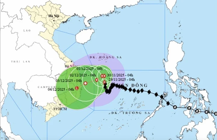
At 4:00 a.m. on December 1, storm No. 15 Koto in the northwest sea area of the central East Sea, about 300km east of the eastern coast of Gia Lai - Dak Lak province, changed direction to the west, moving very slowly, about 3km per hour, gradually weakening. The strongest wind near the storm center was level 9, gusting to level 12.
At 4:00 a.m. on December 2, the center of storm No. 15 Koto was located in the northwest sea area of the central East Sea, about 230km east of the eastern coast of Gia Lai - Dak Lak province, changing direction to West Southwest, speed 3-5km/h. The storm intensity decreased to level 8-9, gusting to level 12.
From the next 72 to 120 hours, the storm will move slowly in the West Southwest direction at a speed of 3-5km/h, and its intensity will continue to weaken.
Impact of storm No. 15, the northwest sea area in the central East Sea has strong winds of level 7-8, near the storm's eye, strong winds of level 9-10, gusts of level 12-13, waves 3-5m high, near the storm's eye 6-8m, very rough seas.
Offshore waters from Gia Lai to Khanh Hoa have strong winds of level 6-7, then increasing to level 8, gusting to level 9-10, waves 4-6m high, rough seas.
News of tropical depression near the East Sea
At 1:00 a.m. on November 29, tropical depression in the sea east of Malaysia. The strongest wind near the center of the tropical depression is level 6-7 (39-61km/h), gusting to level 9, moving northeast at a speed of about 15km/h.
Forecast in the next 24 hours, the tropical depression will enter the southwestern sea area of the South China Sea, East Sea, change direction to East Northeast, moving about 15km per hour, strong intensity level 7, gust level 9.
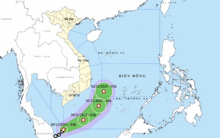
At 1:00 a.m. on December 1, the center of the tropical depression was located in the northwest sea of the South China Sea, continuing to change direction to the northeast and maintaining a speed of about 15 km/h. The strongest wind near the center of the tropical depression was level 6-7, gusting to level 9.
From the next 48 to 72 hours, the tropical depression will move mainly in the Northeast direction, traveling 10-15km per hour, gradually weakening in intensity.
According to the current assessment of the meteorological agency, the possibility of this tropical depression directly affecting the southern mainland is not high.
The circulation of the tropical depression mainly causes strong winds in the western sea area of the South China Sea (including the western sea area of Truong Sa special zone), the eastern sea area from Lam Dong - Ca Mau has strong winds of level 6-7, gusts of level 8, waves 2.5-4m high. Rough seas.
Source: https://baolangson.vn/bao-so-15-koto-lien-tuc-doi-huong-ap-thap-nhiet-doi-sap-vao-bien-dong-5066370.html













Comment (0)