
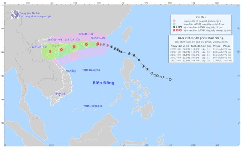
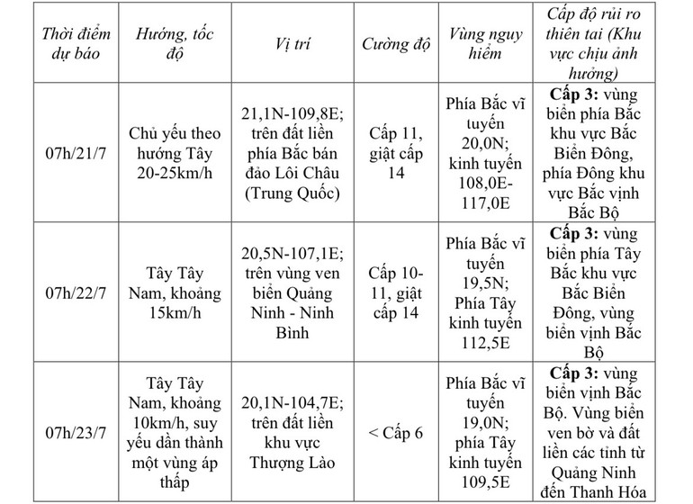
The strongest wind near the storm center is level 11 (103-117km/h), gusting to level 14; moving in the West Northwest direction at a speed of about 20-25km/h.
Storm forecast (next 24-72 hours):
Due to the influence of the storm, in the northern sea area of the North East Sea, the wind is strong at level 8-10, near the storm center, it is level 11-12, gusting at level 15, waves are 5-7m high. The sea is very rough.
From the night of July 20, the northern sea area of Bac Bo Gulf (including Bach Long Vi, Co To, Cat Hai special zones) will have winds gradually increasing to level 6-7, then increasing to level 8-9, near the storm center level 10-11, gusting to level 14, waves 2-4m high, near the center 3-5m. The sea is very rough.
From July 21, the sea in the southern Gulf of Tonkin will have winds gradually increasing to level 6-7, near the storm center level 8-9, gusting to level 11, waves 2-4m high. The sea is very rough.
The meteorological agency warns that ships and boats operating in the above-mentioned dangerous areas are likely to be affected by storms, whirlwinds, strong winds, and large waves.
The coastal areas of Hai Phong - Quang Ninh have storm surges of 0.5-1m high, the water level at Hon Dau ( Hai Phong ) is 3.8-4.1m high, at Cua Ong (Quang Ninh) is 4.8-5.2m high. There is a high risk of flooding in low-lying coastal and river mouth areas at noon and afternoon on July 22.
On land, from the evening and night of July 21, on land from Quang Ninh to Thanh Hoa, winds will gradually increase to level 7-9, gusting to level 10-11; further inland, winds will increase to level 6-7, gusting to level 8-9; near the storm center, winds will increase to level 10-11, gusting to level 14.
Heavy rain is forecast from July 21-23. The Northern and North Central regions are likely to experience widespread heavy rain with rainfall ranging from 100-200mm, locally over 300mm. In particular, the northeastern region, the Northern Delta, Thanh Hoa and Nghe An will experience heavy to very heavy rain with rainfall ranging from 200-350mm, locally over 600mm.
Warning of risk of heavy rain (>150mm/3 hours).
Source: https://nhandan.vn/bao-so-3-giat-cap-14-cach-quang-ninh-hai-phong-khoang-705km-gay-mua-lon-o-bac-bo-va-bac-trung-bo-post894912.html


![[Photo] National Assembly Chairman Tran Thanh Man visits Vietnamese Heroic Mother Ta Thi Tran](https://vphoto.vietnam.vn/thumb/1200x675/vietnam/resource/IMAGE/2025/7/20/765c0bd057dd44ad83ab89fe0255b783)


Comment (0)