
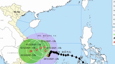
According to the National Center for Hydro-Meteorological Forecasting, at 10:00 a.m. on August 24, the center of storm No. 5 (Kajiki) was located at 17.4 degrees North latitude - 110.9 degrees East longitude, in the northwest sea of Hoang Sa archipelago, about 580 km from Nghe An, about 560 km East Southeast of Ha Tinh . The strongest wind near the center of the storm has increased by 1 level compared to early this morning, currently reaching level 12-13 (118-149 km/h), gusting to level 15. The storm is still moving westward at a speed of about 20 km/h.

It is forecasted that in the next 12 hours, the storm will continue to strengthen. At 10:00 p.m. today, August 24, the storm center will be at about 17.9 degrees North latitude - 108.7 degrees East longitude, in the southern part of the Gulf of Tonkin, about 300km from Nghe An and 270km from Ha Tinh. Wind speed will increase to level 13-14, gusting to level 16.
At 10:00 a.m. on August 25, the storm approached the sea area from Thanh Hoa to Quang Tri , maintaining a level 12-13 intensity, gusting to level 15. From August 26, the storm gradually weakened when it entered mainland Laos and could move to Thailand.
 show that the central sea and southern part of the Gulf of Tonkin are experiencing heavy rain at 11:00 a.m. on August 24.")
At sea, in the Northwest of the East Sea, including the Hoang Sa archipelago, strong winds level 9-11, near the storm center level 12-14, gusting to level 16; waves 5-7m high, near the storm center 8-10m, rough seas.
From noon today, the sea area of Thanh Hoa - Hue (including Hon Ngu and Con Co islands) has winds of level 7-9, then increasing to level 10-11, near the storm center level 12-14, gusts of level 16; waves 5-7m, near the storm center 8-10m. This afternoon, the northern area of Bac Bo Gulf (Cat Hai, Co To, Van Don special zones) has winds of level 6-7, gusts of level 9. The southern part of Bac Bo Gulf (Bach Long Vi island) has winds of level 8-9, gusts of level 11 causing waves 2.5-4.5m high, very rough seas.
The National Center for Hydro-Meteorological Forecasting warns that from Hai Phong to Northern Quang Tri, sea level will rise by 0.5-1.5m; water level at Hon Dau will be 3.3-3.8m, Ba Lat 1.7-2.1m, Sam Son 3.2-3.7m, Hon Ngu 3.2-3.6m, Cua Nhuong 2.2-2.6m. There is a high risk of flooding in low-lying areas, river mouths and coastal areas, especially from the evening of August 25.

On land, from tonight, August 24, the Thanh Hoa - Quang Tri area will have winds of level 8-10, near the storm center level 11-13, gusting to level 14-15. Coastal areas from Quang Ninh to Ninh Binh will have winds of level 6-8, gusting to level 9.
The meteorological agency continues to warn that heavy rain will occur over a wide area from August 24 to 26. The Northern Delta, South Phu Tho, Thanh Hoa - Hue will have 100-150mm of rain, some places will have over 250mm; Thanh Hoa - North Quang Tri will have 200-400mm of rain, some places will have over 700mm, with a risk of extremely heavy rain over 200mm in 3 hours.
From August 25 to 26, Hanoi and Da Nang will have moderate to heavy rain with thunderstorms. Ho Chi Minh City will have showers and thunderstorms in the evening.
Source: https://www.sggp.org.vn/bao-so-5-tang-cap-13-14-giat-sieu-cap-16-vao-dem-nay-post809917.html


Comment (0)