
 |
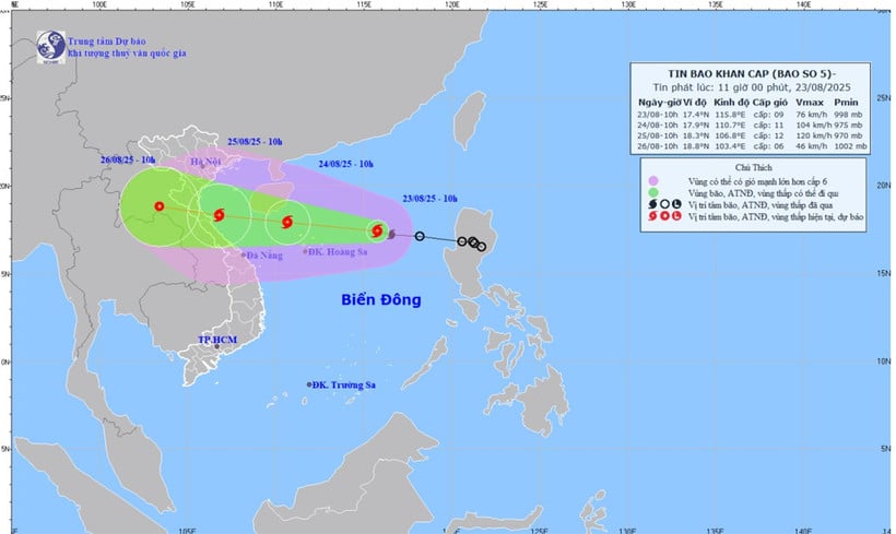
| Forecast map of storm No. 5's trajectory and intensity issued at 11:00 a.m. on August 23. |
The strongest wind near the storm center is level 8-9 (62-88km/h), gusting to level 11; moving in the West Northwest direction at a speed of about 25km/h.
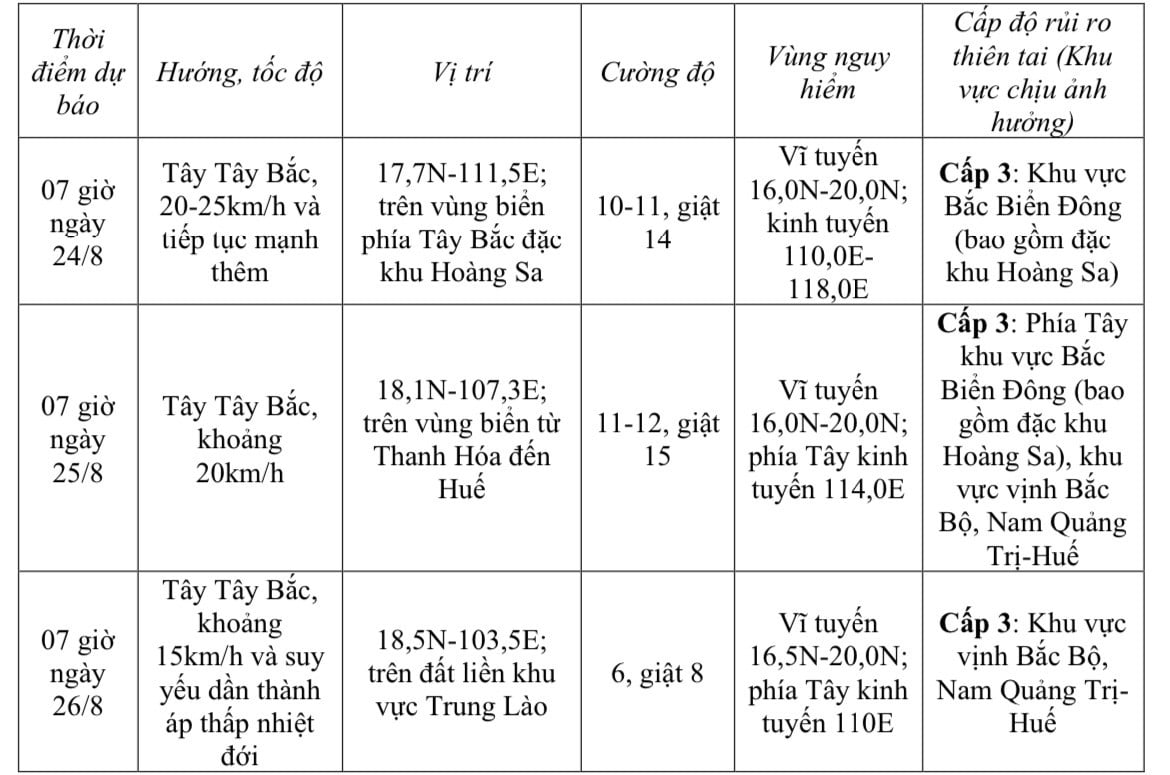
Storm forecast (in the next 24 to 72 hours):
 |
On the sea strong winds, big waves, rising water
Forecast for the North East Sea area (including Hoang Sa special zone) is strong winds of level 8-9, near the storm center, level 10-11, gusts of level 14, waves 4-6m high, rough seas.
From noon and afternoon of August 24, the sea area from Thanh Hoa to Hue (including Con Co and Hon Ngu special zones) will have winds gradually increasing to level 6-8, then increasing to level 9-10, the area near the storm's center will have winds of level 11-12, gusting to level 15, waves 4-6m high, the area near the center will be 6-8m, the sea will be very rough.
From the afternoon of August 24, the northern sea area of Bac Bo Gulf (including Bach Long Vi special zone) has gradually increased winds to level 6-7, gusts to level 9, waves 2-4m high, and rough seas.
Storm surge and flood warning in coastal areas of Thanh Hoa-Quang Tri with storm surge from 0.5-1m high. Water level in Sam Son (Thanh Hoa) is 3.2-3.6m high, in Hon Ngu (Nghe An) is 3.3-3.7m high, in Vung Ang ( Ha Tinh ) is 3.1-3.4m high and in Cua Gianh (Quang Tri) is 1.7-2m high.
High risk of flooding in low-lying coastal areas, river mouths, and islands from Nghe An to Northern Quang Tri.
Weather warning at sea, coastal mainland during storm is extremely dangerous, unsafe for any vehicle, construction operating in the danger zone such as: Cruise ships, passenger ships, transport ships, cages, rafts, aquaculture areas, dykes, embankments, coastal routes. Vehicles are highly likely to capsize, be destroyed, flooded due to strong winds, big waves and rising sea levels.
On land from the night of August 24, from Thanh Hoa to Quang Tri, winds will gradually increase to level 7-9, near the storm center level 10-12, gusting to level 13-15.
From the night of August 24 to the end of August 26, in the Northern Delta, South Phu Tho and from Thanh Hoa to Hue, there is a possibility of widespread heavy rain with common rainfall of 100-150mm, locally over 250mm, especially in the area from Thanh Hoa to Quang Tri, there will be heavy to very heavy rain with common rainfall of 150-300mm, locally over 600mm.
Warning of risk of heavy rain (>200mm/3 hours).
From August 25 to 26, in the capital Hanoi and Da Nang City, there will be moderate rain, heavy rain and thunderstorms; in the Ho Chi Minh City area, there will be rain, showers and thunderstorms in the late afternoon and evening. During thunderstorms, be on guard against the risk of tornadoes and strong gusts of wind.
Source: Nhan Dan Newspaper
Source: https://baodongnai.com.vn/xa-hoi/202508/bao-so-5-tang-cap-giat-cap-11-di-chuyen-theo-huong-tay-tay-bac-b4108ff/


![[Photo] Parade to celebrate the 50th anniversary of Laos' National Day](/_next/image?url=https%3A%2F%2Fvphoto.vietnam.vn%2Fthumb%2F1200x675%2Fvietnam%2Fresource%2FIMAGE%2F2025%2F12%2F02%2F1764691918289_ndo_br_0-jpg.webp&w=3840&q=75)

![[Photo] Worshiping the Tuyet Son statue - a nearly 400-year-old treasure at Keo Pagoda](/_next/image?url=https%3A%2F%2Fvphoto.vietnam.vn%2Fthumb%2F1200x675%2Fvietnam%2Fresource%2FIMAGE%2F2025%2F12%2F02%2F1764679323086_ndo_br_tempimageomw0hi-4884-jpg.webp&w=3840&q=75)


Comment (0)