
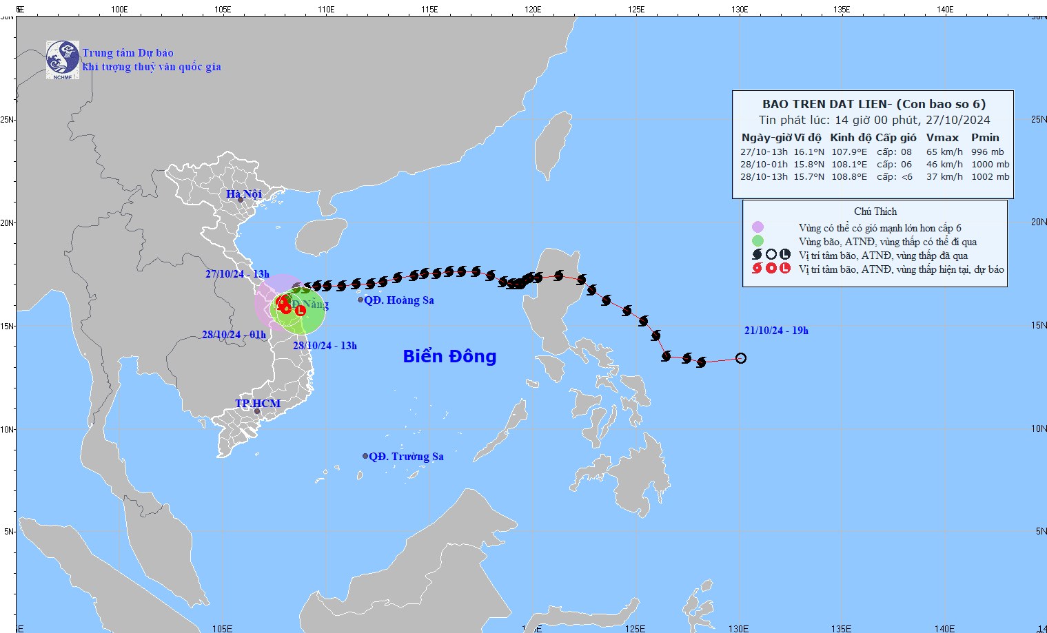
According to the National Center for Hydro-Meteorological Forecasting, this afternoon (October 27), after moving deep into the mainland provinces of Thua Thien Hue, Quang Nam - Da Nang , storm No. 6 weakened into a tropical depression.
Latest update on storm number 6: Has weakened into a tropical depression
According to the National Center for Hydro-Meteorological Forecasting, due to the influence of storm No. 6, Con Co Island (Quang Tri) has strong winds of level 8, gusting to level 9; Cu Lao Cham Island (Quang Nam) has strong winds of level 8, gusting to level 10; Ly Son Island (Quang Ngai) has level 6, gusting to level 7; Le Thuy (Quang Binh) has strong winds of level 7, gusting to level 9; Nam Dong (Thua Thien Hue ) has strong winds of level 8, gusting to level 10; Cam Le (Da Nang) has strong winds of level 8, gusting to level 9; Son Tra (Da Nang) has strong winds of level 9, gusting to level 10.
From last night to this afternoon (October 27), the area from Ha Tinh to Quang Nam has had heavy to very heavy rain. Total rainfall as of 4:00 p.m. on October 27, generally 150-250mm, locally over 400mm.
This afternoon (October 27), after moving deep into the mainland of Thua Thien Hue, Quang Nam-Da Nang provinces, storm No. 6 weakened into a tropical depression.
At 4 p.m., the center of the tropical depression was at about 15.9 degrees North latitude; 107.9 degrees East longitude, on the mainland of Thua Thien Hue, Quang Nam-Da Nang provinces. The strongest wind near the center of the tropical depression was level 7 (50-61 km/h), gusting to level 9. Moving in the South-Southwest direction, speed about 5 km/h.
At 4:00 a.m. on October 28, tropical depression on land in Thua Thien Hue, Quang Nam Da Nang; intensity level 6, gust level 8
At 1:00 p.m. on October 28, the tropical depression weakened into a low pressure area, over the coastal waters of Thua Thien Hue - Quang Nam.
The movement of storm No. 6 has weakened into a tropical depression. Photo: nhmf.
Warning of the impact of tropical depression
Due to the impact of the tropical depression, the sea areas of the provinces from Quang Binh to Quang Ngai (including Con Co Island and Cu Lao Cham) have strong winds of level 6-7, gusts of level 8-9, waves 2.0-4.0m high; rough seas. On land: On land from Quang Binh to Quang Nam there are strong gusts of level 6-8; areas near the center of the tropical depression have strong winds of level 6-7, gusts of level 8-9
From now until the end of the night of October 28, in the area from South Ha Tinh to Thua Thien Hue, there will be heavy to very heavy rain with rainfall from 150-250mm, locally over 400mm; warning of the risk of local heavy rain (>100mm/3 hours). The area from Da Nang to Quang Ngai and Kon Tum will have heavy rain, locally very heavy rain with rainfall from 70-150mm, locally over 200mm.
Emergency flood warning on rivers in Quang Binh, Quang Tri, Thua Thien Hue
Notably, according to the National Center for Hydro-Meteorological Forecasting, in the past 12 hours, floods on rivers in Quang Tri province have risen rapidly.
Water levels at 1:00 p.m. today (October 27) on rivers are as follows: On Ben Hai River at Gia Vong 10.78 m, above alert level 3 by 0.22 m; at Hien Luong 1.87 m, below alert level 2 by 0.13 m. Hieu River at Dau Mau is 23.33 m, below alert level 3 by 0.17 m, at Dong Ha 2.20 m, above alert level 1 by 0.20 m...
From 6-12 hours, floods on rivers will continue to rise and peak at levels below alert level 3, to above alert level 3, the flood peak will remain at a high level; there is a risk of flash floods and landslides on the slopes of mountainous areas in Huong Hoa, Dakrong, Cam Lo districts, western communes of Vinh Linh, Gio Linh, Trieu Phong and Hai Lang districts; landslides at waste dumps of wind power construction projects, Van Ninh - Cam Lo and Cam Lo - La Son expressways.
In Quang Binh, the water level in the Kien Giang River basin is currently rising rapidly and is at a level above alert level 3 to 15m. The water level at 3:00 p.m. on October 27 is as follows: On the Kien Giang River at Kien Giang station 14.35m above alert level 3 1.35m. On the Kien Giang River at Le Thuy station 2.84m above alert level 3 0.14m.
Mr. Phung Tien Dung, Head of Hydrological Forecasting Department, National Center for Hydro-Meteorological Forecasting, due to heavy rain, flooding occurred in many places in Quang Binh, Quang Tri and Thua Thien Hue provinces.
Source: https://danviet.vn/bao-so-6-suy-yeu-lai-quay-nguoc-ra-bien-gay-mua-cuc-lon-toan-mien-trung-nhieu-noi-ngap-lut-20241027165713427.htm


![[Photo] National Assembly Chairman Tran Thanh Man visits Vietnamese Heroic Mother Ta Thi Tran](https://vphoto.vietnam.vn/thumb/1200x675/vietnam/resource/IMAGE/2025/7/20/765c0bd057dd44ad83ab89fe0255b783)


Comment (0)