
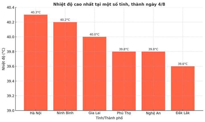
From August 2-4, heat waves and severe heat waves occurred widely in the North and Central regions. In this heat wave, the highest temperatures occurred in the North, concentrated in the midlands and the Northern Delta with the peak of heat waves on August 3 and 4, the highest temperatures were commonly 38-40°C, with some places above 40°C such as Lang ( Hanoi ) at 40.3°C; Phu Ly (Ninh Binh) at 40.2°C. Meanwhile, the highest temperatures in the Central region were only commonly 36-38°C, with some places approaching 39°C.
Mr. Nguyen Van Huong, Head of Weather Forecast Department, National Center for Hydro-Meteorological Forecasting, said that according to statistics, in the North, 20 meteorological stations observed the highest daily temperature value exceeding the previous historical value observed in the same period in August.

"Although the temperature recorded during this heat wave is not the highest ever recorded in the summer in the North (usually occurring in June or July), compared to the same period in August of previous years, this is still a rare temperature. Specifically, 20/85 meteorological stations recorded the highest daily temperature exceeding the historical record ever observed in August," Mr. Huong said.
The Head of the Weather Forecast Department, National Center for Hydro-Meteorological Forecasting also pointed out the cause of this record heat wave.
Accordingly, the hot low in the West is active, pushing dry and hot air to the area; the divergent wind field at high altitude (1,500-3,000m, from North to Northwest) causes less clouds, clear sky, increasing the intensity and duration of sunshine. The westerly to southwest wind at low level, blowing from Thanh Hoa to the plains, brings the foehn wind effect, making the air hotter and the humidity lower. At 1:00 p.m. on August 4, the humidity in Hanoi and the plains was only 47-52%, causing a dry, uncomfortable feeling. The combination of these three factors makes the Northern Delta the hot spot of the heat wave.
From the afternoon and evening of August 5 to August 7, the northern provinces will experience widespread thunderstorms, with the midlands and mountainous areas likely to experience moderate to heavy rain, and in some places very heavy rain.
Therefore, from today, August 6, the heat wave in the Northern provinces will end. It is forecasted that from August 8-11, the heat wave in the North will likely return, while the heat wave in the Central provinces will continue and may end around August 11-12.
According to the 10-day weather forecast update of the National Center for Hydro-Meteorological Forecasting, in the upcoming heat wave, Hanoi, specifically the Hoan Kiem area, will also experience intense heat, with the highest temperature reaching 37°C.
Forecasting further about the heat wave in the North and Central provinces from now until the end of the year, Mr. Huong said that the heat wave will still be concentrated in the North, the area from Thanh Hoa to Hue and the South Central Coast until August 2025. From September, the heat wave will gradually decrease.
Source: https://baolangson.vn/chuyen-gia-nang-nong-hiem-gap-20-tram-vuot-ky-luc-nhet-do-trong-thang-8-5055288.html


![[Photo] Discover the "wonder" under the sea of Gia Lai](https://vphoto.vietnam.vn/thumb/1200x675/vietnam/resource/IMAGE/2025/8/6/befd4a58bb1245419e86ebe353525f97)


![[Photo] Nghe An: Provincial Road 543D seriously eroded due to floods](https://vphoto.vietnam.vn/thumb/1200x675/vietnam/resource/IMAGE/2025/8/5/5759d3837c26428799f6d929fa274493)


Comment (0)