
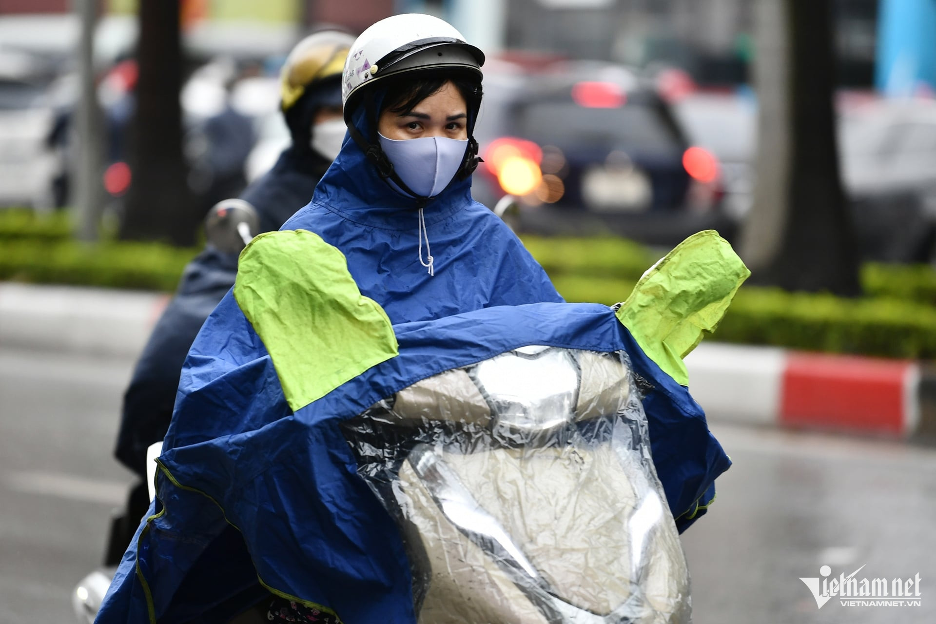
Weather forecast October 28, 2024, Hanoi has rain, early morning and night cold, highest temperature 27 degrees. Area from South Ha Tinh - Thua Thien Hue has heavy to very heavy rain with rainfall from 150-250mm, locally over 400mm.
According to the National Center for Hydro-Meteorological Forecasting, early this morning (October 28), the tropical depression (weakened from storm No. 6) has weakened into a low pressure area on the mainland along the coast of Quang Nam - Da Nang. It is forecasted that in the next 12 hours, the low pressure area will move mainly in the East-Northeast direction, weakening and gradually dissipating.
However, the situation of heavy rain in the provinces from South Ha Tinh to Thua Thien Hue, strong winds and big waves in the Gulf of Tonkin, the sea area from Quang Tri to Ninh Thuan and the northern part of the North East Sea area is still complicated.
The meteorological agency warned that from October 28 to 29, in the area from South Ha Tinh to Thua Thien Hue, there will be heavy to very heavy rain with rainfall from 150-250mm, locally over 400mm; warning of the risk of local heavy rain (>100mm/3 hours).
On the day and night of October 30, in the area from South Ha Tinh to Quang Nam, there will be moderate rain, heavy rain, locally very heavy rain and thunderstorms with rainfall from 30-60mm, locally over 80mm.
Heavy rain and localized heavy rain are likely to cause flooding in low-lying areas; flash floods in small rivers and streams, and landslides on steep slopes.
In addition, the Northern region is experiencing a cold spell that has caused temperatures to drop significantly and showers to appear.
Weather forecast for October 28, 2024 in detail for regions across the country:
Hanoi
Cloudy with rain in some places. Northeast to north wind level 2-3. Cold early morning and night.
Lowest temperature: 19-21 degrees.
Highest temperature: 25-27 degrees.
Northwest
Cloudy, with rain in some places, except in the Northwest, the clouds will clear up and the afternoon will be sunny. Light wind. Early morning and night will be cold, with some places freezing.
Lowest temperature: 19-22 degrees, some places below 18 degrees.
Highest temperature: 27-30 degrees, some places above 30 degrees.
Northeast
Cloudy, with rain in some places, especially in the plains and coastal areas at night with scattered showers and thunderstorms in some places. Northeast to north wind level 3, coastal areas level 4. Cold in the early morning and at night, cold in the mountains.
Lowest temperature: 18-21 degrees, mountainous areas below 17 degrees.
Highest temperature: 24-27 degrees, some places above 28 degrees.
Thanh Hoa - Thua Thien Hue
Cloudy, scattered showers and thunderstorms in the North (Thanh Hoa - North Ha Tinh); moderate to heavy rain, locally very heavy rain in the South. North to northwest wind level 3-4. Cold early morning and night.
Lowest temperature: 19-22 degrees.
Highest temperature: 22-25 degrees.
Da Nang - Binh Thuan
Cloudy, scattered showers and thunderstorms in the morning; scattered showers and thunderstorms in the afternoon. Southwest wind level 3-4.
Lowest temperature: 22-25 degrees.
Highest temperature: 24-27 degrees, South 28-31 degrees.
Central Highlands
Cloudy, scattered showers and thunderstorms during the day, scattered showers and thunderstorms at night. Southwest wind force 3. Thunderstorms may cause tornadoes, lightning and strong gusts of wind.
Lowest temperature: 17-20 degrees.
Highest temperature: 21-24 degrees, in the South some places above 25 degrees.
Southern Vietnam
Cloudy with scattered showers and thunderstorms, locally heavy rain. Southwest wind level 3. Thunderstorms may produce tornadoes, lightning, and strong gusts of wind.
Lowest temperature: 23-26 degrees.
Highest temperature: 28-31 degrees, some places above 31 degrees.
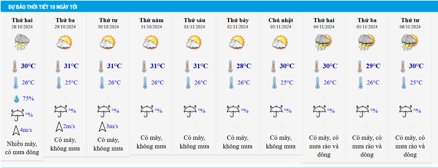
Weather in Ho Chi Minh City in the coming days:
Source: https://vietnamnet.vn/du-bao-thoi-tiet-28-10-2024-ha-noi-mua-lanh-ha-tinh-hue-mua-to-400mm-sau-bao-so-6-2336098.html


![[Photo] Closing ceremony of the 18th Congress of Hanoi Party Committee](https://vphoto.vietnam.vn/thumb/1200x675/vietnam/resource/IMAGE/2025/10/17/1760704850107_ndo_br_1-jpg.webp)


![[Photo] Nhan Dan Newspaper launches “Fatherland in the Heart: The Concert Film”](https://vphoto.vietnam.vn/thumb/1200x675/vietnam/resource/IMAGE/2025/10/16/1760622132545_thiet-ke-chua-co-ten-36-png.webp)


Comment (0)