Impact of complex faults

The 7.5-magnitude earthquake that occurred in the Noto Peninsula, Japan, has given scientists a headache due to the complex shape of the shifting fault lines (Illustration: SciTechDaily).
On January 1, 2024, a magnitude 7.5 earthquake occurred on the Noto Peninsula in North Central Japan, causing a strong shock not only in the geological world but also in the scientific community.
The most notable phenomenon was the enormous ground uplift, up to 5 meters in some areas. This is much higher than usual in similar earthquakes.
Researchers at the University of Tokyo recently published a study that decodes this phenomenon through advanced three-dimensional simulations, based on real data from underground faults.
According to Associate Professor Ryosuke Ando, head of the research team, the main cause comes from the irregular geometry and complex segmentation of tectonic faults. This is also the factor that governs the entire dynamics of the earthquake.
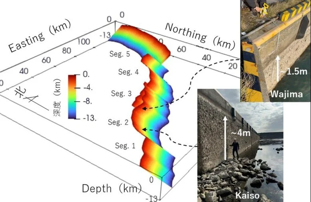
Unlike the uniform uplift phenomenon common in other earthquakes, the Noto earthquake showed a very uneven distribution of ground uplift, ranging from 1-2 meters in many places, but soaring to 4-5 meters in some specific areas.
Solving the mystery with 3D seismic simulation

Supercomputer simulations decode the mechanism of irregular earthquake faults (Photo: University of Tokyo).
Using supercomputer seismic simulations, scientists built a detailed three-dimensional model that recreates the fault's movement based on satellite data, seismic records, and field surveys.
This model shows that the earthquake involved three major faults. These faults not only had different slip directions, but also tilted in opposite directions, causing large fluctuations in slip and uplift at each location.
In areas where the fault is perpendicular to the main direction of compression from the tectonic plate, slip occurs most efficiently and results in stronger ground uplift.
This explains why some areas can experience uplifts of several meters in the same earthquake, while others may experience only slight uplifts or almost no change. Notably, the consistency between the simulation results and actual satellite measurements further strengthens the credibility of the study.
This is considered a major step forward in understanding the physical mechanisms that control earthquakes and the local impact of fault geometry - a factor that has long been underestimated in disaster prediction models.
Looking ahead, the team believes that the model could be used to build more accurate earthquake scenarios, especially in areas with complex geological activity such as Japan.
"We hope that 3D fault simulation models will become a key tool in assessing large earthquake risks and mitigating natural disaster risks," Associate Professor Ando shared.
Source: https://dantri.com.vn/khoa-hoc/giai-ma-hien-tuong-mat-dat-troi-len-5-met-sau-tham-hoa-o-nhat-ban-20250513134208599.htm


![[Photo] Prime Minister Pham Minh Chinh chairs conference on anti-smuggling, trade fraud, and counterfeit goods](https://vphoto.vietnam.vn/thumb/1200x675/vietnam/resource/IMAGE/2025/5/14/6cd67667e99e4248b7d4f587fd21e37c)


Comment (0)