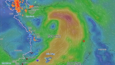
TPO – A tropical depression that formed in the waters east of the Philippines is forecast to enter the South China Sea tomorrow (September 17), strengthening into a typhoon around September 18, after which two scenarios are possible for it to make landfall in Vietnam.
At 1 PM today (September 16th), the center of the tropical depression was located at approximately 17.1 degrees North latitude and 123.9 degrees East longitude, over the sea east of Luzon Island in the Philippines, with maximum sustained winds near the center of the tropical depression reaching levels 6-7 (39-61 km/h), gusting to level 9.
According to Mr. Nguyen Van Huong, Head of the Weather Forecasting Department (National Center for Meteorological and Hydrological Forecasting), the tropical depression will enter the East Sea around the morning of September 17th. However, due to unfavorable environmental conditions (having to share moisture and energy with the storm currently active in the Northwest Pacific), the tropical depression will take 1-2 days to stabilize its structure after entering the East Sea.
Forecasts indicate that around September 18th, the tropical depression may strengthen into a typhoon, moving towards the central South China Sea, near the Hoang Sa archipelago of Vietnam.
 |
| Mr. Nguyen Van Huong, Head of the Weather Forecasting Department of the National Center for Meteorological and Hydrological Forecasting, shared information about the tropical depression. |
According to Mr. Huong, when the storm reaches this area, its path will be very complex due to the large-scale fluctuations of the steering current from the subtropical high-pressure system and the impact of cold air from after September 19th.


The National Center for Meteorological and Hydrological Forecasting has identified two possible scenarios.
In the first scenario, the storm will move directly into the central region of Vietnam, focusing on the provinces in the Central Central region. According to this scenario, the storm will affect the mainland of Vietnam relatively early, around September 19-20.
The second scenario is that, upon reaching the Hoang Sa archipelago, the storm changes direction to west-northwest, heading towards the northern and north-central regions of Vietnam. Under this scenario, the storm could directly affect the mainland of Vietnam by the end of this week.
Regarding the storm's intensity, according to assessments by Vietnam and major meteorological stations worldwide , its development will be complex and unpredictable, depending on the influence of many conditions. However, this storm is unlikely to erupt and be as powerful as Super Typhoon Yagi.
Mr. Huong noted that from the morning of September 17th, due to the influence of a tropical depression, the eastern sea area of the North East Sea experienced heavy rain and thunderstorms, strong winds of level 7 (50-61 km/h), gusts of level 9 (75-88 km/h), rough seas, and waves 2-4 meters high. Vessels operating in dangerous areas are likely to be affected by strong winds and high waves.
Experts also noted that, due to the complex trajectory and intensity of the storm, it is necessary to continuously update the latest forecast bulletins.


Tienphong.vn
Source: https://tienphong.vn/hai-kich-ban-vao-dat-lien-cua-bao-so-4-post1673689.tpo


![[Image] National conference summarizing one year of operation of the overall organizational model of the political system, the three-tiered government model.](https://vphoto.vietnam.vn/thumb/1200x675/vietnam/resource/IMAGE/2026/07/01/1782882811691_ndo_br_1-jpg.webp)