
This information was confirmed by Mr. Tran Manh Cuong, Director of Nam Ha Tinh Irrigation Company Limited, to a reporter from Ha Tinh Newspaper on the night of October 30th. The water level of Ke Go Reservoir is at an elevation of 31.15/32.5m, equivalent to a capacity of 303.75/345 million m³ , and water is currently being regulated through the Doc Mieu spillway at a flow rate of 90 m³ /second.

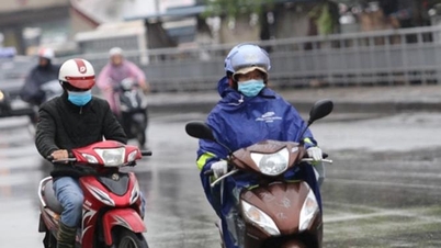
According to the forecast of the Ha Tinh Meteorological and Hydrological Station, due to the influence of a cold front combined with an upper-level easterly wind disturbance, from the evening of October 30th to the end of November 1st, the entire province will experience heavy rain, with some areas experiencing very heavy rain. Rainfall amounts will generally range from 150 to 300 mm, with some areas exceeding 400 mm. In particular, rainfall in the southern coastal plains will range from 200 to 400 mm, with some areas exceeding 600 mm.
From the night of November 1st to November 2nd, the Ha Tinh area is forecast to experience heavy rainfall again, with amounts ranging from 100 to 200 mm, and in some places exceeding 300 mm.
Ahead of heavy rainfall forecasts, and with the Ke Go reservoir already at over 88% of its designed capacity, Nam Ha Tinh Irrigation Company Limited will increase the spillway discharge rate from 90 m³ /second to 100-350 m³ /second from 6:00 AM on October 31st, depending on weather developments.
“Since October 21st, the unit has started regulating water from Ke Go Lake through the Doc Mieu spillway. Now, with heavy rain forecasts and complex developments, the unit has increased the spillway discharge rate from 6:00 AM on October 31st. This proactive water regulation aims to lower the lake's water level, increase flood control capacity, and ensure the safety of the structure and downstream areas in the event of prolonged heavy rain,” informed Tran Manh Cuong, Director of Nam Ha Tinh Irrigation Company Limited.

Along with Ke Go Reservoir, Nam Ha Tinh Irrigation Company Limited is currently releasing water from several large reservoirs in the province. Given the complex situation of heavy rainfall, the company is also increasing the reservoir release rate to lower water levels and increase flood control capacity.
Specifically, the Song Rac reservoir is discharging at 353 m³ /second, with the possibility of increasing the discharge rate to 800 m³ /second; the Thuong Song Tri reservoir is discharging at 50 m³ /second, with the possibility of increasing to 70-400 m³ /second. The discharge rate will depend on weather conditions.
In addition, the Ho Ho Hydropower Plant also regulates water flow through the spillway at a rate of 150 m³ /second.

To proactively respond to prolonged heavy rainfall, Ha Tinh province has requested units and localities to deploy rapid response forces to inspect and review residential areas along rivers and streams, low-lying areas, and areas at risk of flooding, flash floods, and landslides, in order to proactively prevent and respond to the situation.
Organize forces to guard, control, support, and guide traffic to ensure safety for people and vehicles, especially at underpasses, overflows, areas with deep flooding, areas with strong currents, and areas where landslides have occurred or are at risk of occurring.
Implement measures to ensure the safety of dikes, irrigation and hydropower reservoirs, and downstream areas; deploy permanent forces to operate and regulate reservoirs to ensure the safety of the structures and downstream areas, drainage channels, ensure flood control, and be ready to handle any potential situations.
Prepare personnel and equipment for rescue operations when required.
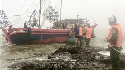
Due to heavy rain on October 30th, flooding occurred in several communes and wards in the southern part of Ha Tinh province. Specifically, 146 households in Vung Ang ward, 59 households in Ky Xuan commune, and 24 households in Ky Thuong commune were flooded.
Vung Ang ward organized the evacuation of 146 households/334 people; Ky Thuong commune evacuated 135 households/166 people from flooded areas to safe locations.
Several inter-village and inter-commune roads were partially flooded, including: 5 roads in Vung Ang ward (2km in length); 6 roads in Hai Ninh ward (4.2km in length); 7 roads in Song Tri ward (0.6km in length); 8 roads in Ky Xuan commune (0.63km in length); 5 roads in Hoanh Son ward (1km in length); 6 roads in Ky Thuong ward (0.12km in length); and 5 roads in Cam Due commune (0.62km in length).
Source: https://baohatinh.vn/ho-ke-go-tang-luu-luong-xa-tran-tu-6h-sang-nay-post298463.html

![[Image] Leaked images ahead of the 2025 Community Action Awards gala.](/_next/image?url=https%3A%2F%2Fvphoto.vietnam.vn%2Fthumb%2F1200x675%2Fvietnam%2Fresource%2FIMAGE%2F2025%2F12%2F16%2F1765882828720_ndo_br_thiet-ke-chua-co-ten-45-png.webp&w=3840&q=75)
![[Photo] Prime Minister Pham Minh Chinh receives Lao Minister of Education and Sports Thongsalith Mangnormek](/_next/image?url=https%3A%2F%2Fvphoto.vietnam.vn%2Fthumb%2F1200x675%2Fvietnam%2Fresource%2FIMAGE%2F2025%2F12%2F16%2F1765876834721_dsc-7519-jpg.webp&w=3840&q=75)

![[Live] 2025 Community Action Awards Gala](/_next/image?url=https%3A%2F%2Fvphoto.vietnam.vn%2Fthumb%2F1200x675%2Fvietnam%2Fresource%2FIMAGE%2F2025%2F12%2F16%2F1765899631650_ndo_tr_z7334013144784-9f9fe10a6d63584c85aff40f2957c250-jpg.webp&w=3840&q=75)
![[Photo] Prime Minister Pham Minh Chinh receives the Governor of Tochigi Province (Japan)](/_next/image?url=https%3A%2F%2Fvphoto.vietnam.vn%2Fthumb%2F1200x675%2Fvietnam%2Fresource%2FIMAGE%2F2025%2F12%2F16%2F1765892133176_dsc-8082-6425-jpg.webp&w=3840&q=75)


![[Photo] Prime Minister Pham Minh Chinh attends the Vietnam Economic Forum 2025](https://vphoto.vietnam.vn/thumb/402x226/vietnam/resource/IMAGE/2025/12/16/1765893035503_ndo_br_dsc-8043-jpg.webp)


Comment (0)