

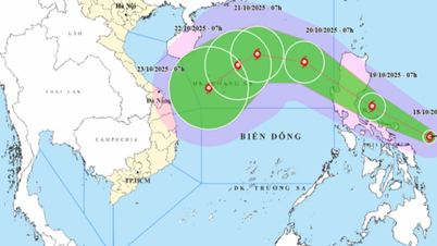
Forecast of storm Fengshen's path
Tomorrow evening, storm Fengshen will enter the East Sea.
According to the meteorological agency, early this morning a tropical depression in the sea east of the Philippines intensified into a storm. This is the 24th storm in the Northwest Pacific region and has the international name of Typhoon Fengshen, named by China.
Fengshen means "God of Wind" in Chinese. It is currently a strong storm of level 8 (62-74km/h), with gusts of level 10.
It is forecasted that by tomorrow morning (October 19), the storm will make landfall in the Luzon island area. Tomorrow afternoon and evening, the storm will pass through Luzon island and enter the East Sea, becoming storm number 12.
It is forecasted that after moving into the East Sea, storm No. 12 will move mainly in a west-northwest direction with a tendency to intensify. By around October 22, when the storm moves to the northern area of Hoang Sa special zone, it will reach level 11, gusting to level 13.
However, the characteristic of storm No. 12 when the storm moves into the East Sea is that it encounters cold air blocking the western part, making it less likely that the storm will move westward to enter the North or go up to the Chinese region. According to analysis, storm No. 12 will be penetrated by cold air and gradually weaken.
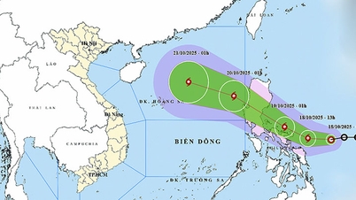
Two scenarios for storm developments
The meteorological agency assessed that it is likely that storm Fengshen (storm number 12) will weaken into a tropical depression before affecting the mainland of the central provinces.
Although the possibility of maintaining the storm's intensity to affect the Central mainland is not high, but with the impact of the storm's circulation combined with cold air in the northern seas, the middle of the East Sea (including Hoang Sa special zone), the Gulf of Tonkin as well as the sea area from Quang Tri to Quang Ngai in the coming days, there will often be strong winds from level 6-8 or higher, waves from 3-4m high, and rough seas.
In addition, due to the influence of post-storm circulation No. 12 combined with the impact of cold air, from October 23 to 26, the area from Ha Tinh to Quang Ngai will experience a widespread period of moderate to heavy rain.
The meteorological agency also emphasized that the interaction of cold air and storms is one of the types of interactions with many scenarios.
If the storm comes first and cold air comes later, or if the storm and cold air interact, it will cause very heavy rain.
In case the cold air comes first and then the storm comes, the rain will not be too heavy.
Currently, the rain scenarios as well as the impact of storms on the Vietnamese mainland still depend a lot on the development of cold air. Therefore, people need to closely monitor the simultaneous development of the storm's path and the impact of cold air.
Source: https://tuoitre.vn/cuu-tinh-khong-khi-lanh-khac-che-bao-fengsheng-than-gio-ra-sao-20251018115445366.htm
![[Photo] General Secretary To Lam attends the 95th Anniversary of the Party Central Office's Traditional Day](https://vphoto.vietnam.vn/thumb/1200x675/vietnam/resource/IMAGE/2025/10/18/1760784671836_a1-bnd-4476-1940-jpg.webp)

![[Photo] Collecting waste, sowing green seeds](https://vphoto.vietnam.vn/thumb/1200x675/vietnam/resource/IMAGE/2025/10/18/1760786475497_ndo_br_1-jpg.webp)

![[Photo] Immerse yourself in the colorful musical world of “Secret Garden Live in Vietnam”](https://vphoto.vietnam.vn/thumb/1200x675/vietnam/resource/IMAGE/2025/10/18/1760805978427_ndo_br_thiet-ke-chua-co-ten-41-png.webp)
![[Photo] Closing ceremony of the 18th Congress of Hanoi Party Committee](https://vphoto.vietnam.vn/thumb/1200x675/vietnam/resource/IMAGE/2025/10/17/1760704850107_ndo_br_1-jpg.webp)


Comment (0)