
Rainfall generally ranges from 150mm-250mm, with many places experiencing exceptionally heavy rains of over 300mm. Some places with exceptionally high rainfall include:
Thua Thien Hue Province: Bach Ma Peak 632mm, Thuong Lo 574mm, Giang Hai 378mm; Da Nang City: Suoi Luong 421mm, Hoa Hai 380mm; Quang Nam: Dai Hiep and Dai Son both reached 363mm, Ha Tan Bridge 354mm; Quang Binh: Trung Thuan Lake 221mm, Vuc Tron Lake 220mm; Quang Tri: La To Hydropower Plant 262mm, A Bung 223mm; Kon Tum: Dak Ro Ong 165mm, Dak Ha 162mm.
Many rivers rose above alert level 1. Water levels measured at 10:00 a.m. on June 12 at several stations were as follows: Kien Giang River ( Quang Binh ): 8.59m, exceeding alert level 1 by 0.59m; Ta Trach River (Hue) at Thuong Nhat: 60.34m, exceeding 1.34m; Vu Gia River (Quang Nam) at Ai Nghia: 7.23m, exceeding 0.73m; Cai River (Quang Nam) at Thanh My: 16.27m, exceeding 1.27m.
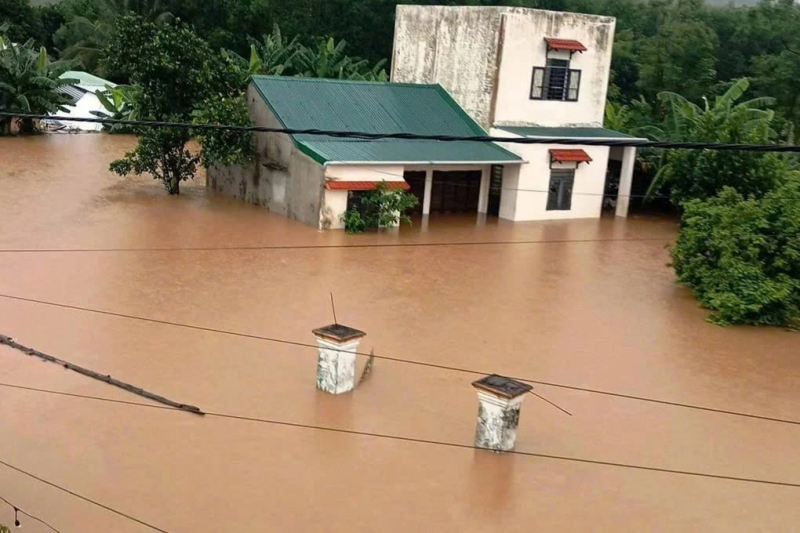
Regarding the damage, there have been no recorded human casualties. Regarding housing, about 300 houses in Dai Loc district, Quang Nam province were flooded. Two fishing boats from Quang Binh (QB-93451-TS and QB-92756-TS, each with 4 workers) sank while operating at sea on June 11. In addition, a boat anchored in Da Nang also sank. All 8 crew members were safely rescued by fishing boats QB-93964-TS and QB-92405-TS.
Agricultural damage, a total of 22,500 hectares of rice and crops were flooded. Of which, Thua Thien Hue 12,758 hectares, Da Nang 1,497 hectares, Quang Tri 8,246 hectares. In addition, 33 hectares of aquaculture in Da Nang were also affected.
Regarding traffic: In Quang Tri, 7 underground spillways in Dakrong district were flooded. In Thua Thien Hue, the slope of the slope collapsed on Route 14C, La Son-Tuy Loan Road (Phu Loc District) and Ho Chi Minh Road through Km350 (A Luoi District). In Da Nang, some inner-city roads were flooded, but the water has now receded. Landslides occurred at 2 points on rural traffic routes. In Quang Nam, some locations on Routes DT.603B, DT.609 and DT.615B were flooded.
Source: https://cand.com.vn/doi-song/mua-lu-khien-300-nha-dan-o-huyen-dai-loc-tinh-quang-nam-bi-ngap-lut-i771366/

![[Photo] Panorama of the Opening Ceremony of the National Press Festival 2025](https://vphoto.vietnam.vn/thumb/1200x675/vietnam/resource/IMAGE/2025/6/20/6b835ee92c2c4df587af73cb2d1f4f5f)


![[Photo] General Secretary To Lam chairs the 14th Central Military Commission Conference](https://vphoto.vietnam.vn/thumb/1200x675/vietnam/resource/IMAGE/2025/6/20/a9d25fc6dd664fb9a3757502f32e5db0)


![[Maritime News] Wan Hai Lines invests $150 million to buy 48,000 containers](https://vphoto.vietnam.vn/thumb/402x226/vietnam/resource/IMAGE/2025/6/20/c945a62aff624b4bb5c25e67e9bcc1cb)


Comment (0)