
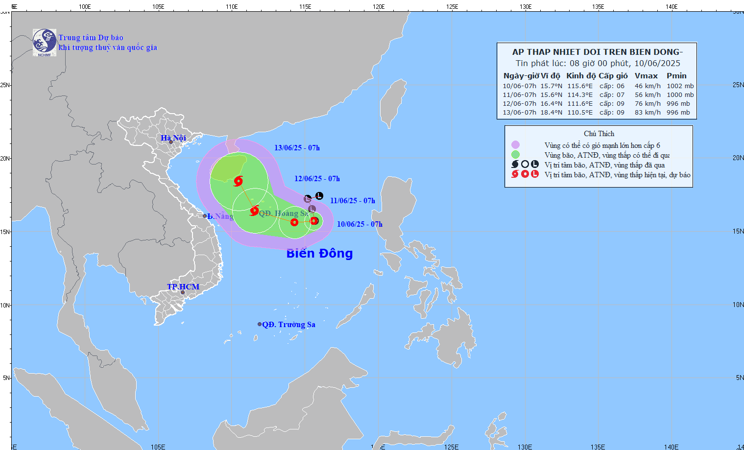
At 7:00 a.m. on June 10, the center of the tropical depression was at about 15.7 degrees North latitude; 115.6 degrees East longitude, about 360 km East Southeast of Hoang Sa archipelago. The strongest wind near the center of the tropical depression was level 6 (39-49 km/h), gusting to level 8; moving slowly westward at a speed of about 5 km/h.
It is forecasted that by 7am on June 11, the tropical depression will move west at a speed of about 5km/h and is likely to strengthen. Its current location is about 15.6 degrees North latitude and 114.3 degrees East longitude, about 240km East Southeast of the Paracel Islands. Wind force is level 7, gusting to level 9.
The dangerous area in the East Sea with strong winds of level 6 or higher is between 13.0 and 18.5 degrees North latitude and 112.0 and 118.0 degrees East longitude.
The level of disaster risk due to strong winds at sea is warned at level 3, affecting the northern East Sea area (including Hoang Sa archipelago) and the northern area of the central East Sea.
By 7am on June 12, the tropical depression is likely to strengthen into a storm and move west-northwest at a speed of 10-15km/h. The storm center is currently located over the Hoang Sa archipelago, at approximately 16.4 degrees north latitude and 111.6 degrees east longitude. Winds are at level 8-9, gusting to level 11.
The danger zone is extended from 13.5 to 18.5 degrees North latitude and from 109.5 to 117.0 degrees East longitude.
The disaster risk level remains at level 3, affecting the northern East Sea area, the northern area between the East Sea and offshore waters from Quang Tri to Quang Ngai .
Warning: In the next 48-72 hours, the storm is likely to change direction, moving to the North-Northwest at a speed of about 10 km/h and is likely to continue to strengthen.
Forecast for the North East Sea and the North of the central East Sea area is thunderstorms, strong winds level 6-7, gusts level 9; rough seas, waves 2-4m high.
Vessels in the danger zone should be aware of the high risk of thunderstorms, tornadoes, strong winds and large waves.
TS
Source: https://baothanhhoa.vn/ngay-12-6-ap-thap-nhiet-doi-co-kha-nang-manh-len-thanh-bao-251583.htm


![[Photo] President Luong Cuong talks on the phone with South Korean President Lee Jae Myung](https://vphoto.vietnam.vn/thumb/1200x675/vietnam/resource/IMAGE/2025/6/13/eee54a4c903f49bda277272b1dda68e8)


Comment (0)