
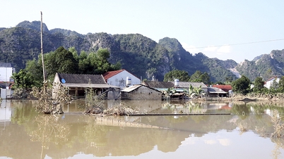
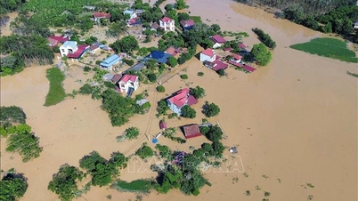
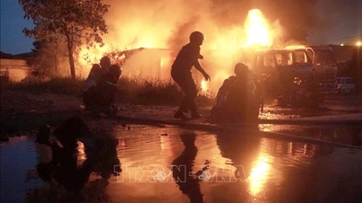
Currently, the flood on Cau River and Thuong River ( Bac Ninh ) is receding. The water level at 3:00 p.m. on October 11 on the rivers is as follows: On Cau River at Dap Cau station 6.63m, 0.33m above alarm level 3; on Thuong River at Cau Son station 15.12m, 0.12m above alarm level 2; at Phu Lang Thuong station 7.19m, 0.89m above alarm level 3, 0.34m below the historical flood in 1986 (7.53m).
It is forecasted that in the next 12 hours, flood on Cau River at Dap Cau station will continue to decrease and be below alert level 3; flood on Thuong River at Phu Lang Thuong station will continue to decrease and remain above alert level 3.
In the next 12-24 hours, flood on Cau River at Dap Cau station will continue to decrease and stay above alert level 2; flood on Thuong River at Phu Lang Thuong station will continue to decrease and stay above alert level 3.
Flood on Thai Binh River (Hai Phong) at Pha Lai station will decrease and be below alert level 1.
Flooding in Thai Nguyen, Bac Ninh, Lang Son provinces and Hanoi city continues in riverside communes and wards and may last for the next 1-2 days, especially in low-lying areas where it may last for the next 2-3 days; there is a risk of riverbank and river dike erosion and landslides on slopes in the above areas.
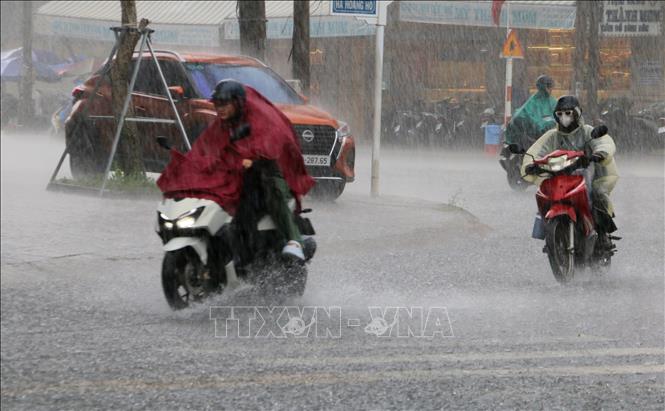
Thunderstorms and strong winds at sea
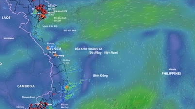
Currently, the low pressure trough has an axis at about 12-15 degrees North latitude connecting with the low pressure area at 13:00 located at about 11.5-12.5 degrees North; 110.5-111.5 degrees East. The Central and Southern East Sea area (including Truong Sa special zone) has scattered showers and thunderstorms.
Forecast for the night of October 11 and the day of October 12, the sea area from South Quang Tri to Ca Mau, Ca Mau to An Giang , the Gulf of Thailand, the Central and Southern East Sea (including Truong Sa special zone) will have scattered showers and thunderstorms. During the thunderstorms, there is a possibility of tornadoes, strong gusts of wind of level 6-7 and waves over 2m high. All vessels operating in the above areas are at risk of being affected by tornadoes and strong gusts of wind.
Specific weather in each region
The Northwest region has scattered showers and thunderstorms. During thunderstorms, watch out for the possibility of tornadoes, lightning, and strong gusts of wind. The lowest temperature ranges from 22 to 25 degrees Celsius, below 22 degrees Celsius in some places; the highest temperature ranges from 30 to 33 degrees Celsius.
The Northeast region also has scattered showers and thunderstorms. Be wary of tornadoes, lightning, and strong gusts of wind during thunderstorms. The lowest temperature ranges from 23 to 26 degrees Celsius, in mountainous areas it can be below 23 degrees Celsius; the highest temperature ranges from 30 to 33 degrees Celsius.
In the late afternoon and at night, the area from Thanh Hoa to Hue will have scattered showers and thunderstorms, with some places having heavy rain. During the day, there will be showers and thunderstorms in some places. Light wind. During thunderstorms, there is a possibility of tornadoes, lightning and strong gusts of wind. The lowest temperature is from 23 to 26 degrees Celsius, the highest is from 29 to 32 degrees Celsius.
The South Central Coast has scattered showers and thunderstorms. In the afternoon and evening, there will be scattered showers and thunderstorms, with some places having heavy rain. During thunderstorms, tornadoes, lightning and strong gusts of wind may occur. The lowest temperature is from 23 to 26 degrees Celsius, the highest is from 29 to 32 degrees Celsius.
The Central Highlands also has scattered showers and thunderstorms. In the afternoon and evening, there will be scattered showers and thunderstorms, with some places experiencing heavy rain. Be wary of tornadoes, lightning, and strong gusts of wind during thunderstorms. The lowest temperature ranges from 19 to 22 degrees Celsius, and the highest from 28 to 31 degrees Celsius.
The South has scattered showers and thunderstorms. In the afternoon and evening, there will be scattered showers and thunderstorms, with some heavy rain. Light winds. During thunderstorms, tornadoes, lightning, and strong gusts of wind may occur. The lowest temperature is from 23 to 26 degrees Celsius, the highest is from 29 to 32 degrees Celsius.
Hanoi is cloudy, with showers and thunderstorms in the late afternoon and at night, with some heavy rain in some places. During the day, it is sunny. During thunderstorms, there is a possibility of tornadoes, lightning and strong gusts of wind. The lowest temperature is from 23 to 25 degrees Celsius, the highest is from 31 to 33 degrees Celsius.
Ho Chi Minh City has scattered showers and thunderstorms. In the afternoon and evening, there will be scattered showers and thunderstorms, with heavy rain in some places. During thunderstorms, there is a risk of tornadoes, lightning and strong gusts of wind. The lowest temperature is from 24 to 26 degrees Celsius, the highest is from 29 to 31 degrees Celsius.
Source: https://baotintuc.vn/xa-hoi/nhieu-khu-vuc-co-mua-ve-chieu-toi-va-dem-lu-tren-cac-song-tiep-tuc-xuong-20251011180423688.htm
![[Photo] Opening of the World Cultural Festival in Hanoi](https://vphoto.vietnam.vn/thumb/1200x675/vietnam/resource/IMAGE/2025/10/10/1760113426728_ndo_br_lehoi-khaimac-jpg.webp)

![[Photo] Discover unique experiences at the first World Cultural Festival](https://vphoto.vietnam.vn/thumb/1200x675/vietnam/resource/IMAGE/2025/10/11/1760198064937_le-hoi-van-hoa-4199-3623-jpg.webp)

![[Photo] General Secretary attends the parade to celebrate the 80th anniversary of the founding of the Korean Workers' Party](https://vphoto.vietnam.vn/thumb/1200x675/vietnam/resource/IMAGE/2025/10/11/1760150039564_vna-potal-tong-bi-thu-du-le-duyet-binh-ky-niem-80-nam-thanh-lap-dang-lao-dong-trieu-tien-8331994-jpg.webp)


![[Photo] Ho Chi Minh City is brilliant with flags and flowers on the eve of the 1st Party Congress, term 2025-2030](https://vphoto.vietnam.vn/thumb/1200x675/vietnam/resource/IMAGE/2025/10/10/1760102923219_ndo_br_thiet-ke-chua-co-ten-43-png.webp)


Comment (0)