
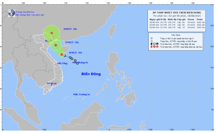
According to the National Center for Hydro-Meteorological Forecasting, at 1:00 a.m. on August 18, the center of the tropical depression was at about 18.1 degrees North latitude - 109.1 degrees East longitude, in the sea south of Hainan Island (China).
The strongest wind near the center of the tropical depression is level 6 (39-49 km/h), gusting to level 8; moving northwest at a speed of about 15 km/h.
Forecast map of tropical depression trajectory and intensity at 2:00 a.m. on August 18
It is forecasted that in the next 24 hours, by 1:00 a.m. on August 19, the tropical depression will be at about 20.3 degrees North latitude - 107.7 degrees East longitude, in the northern area of Bac Bo Gulf. The strongest wind will remain at level 6, gusting to level 8.
The disaster risk level is warned at level 3, directly affecting the eastern sea area from the southern region of Quang Tri to Hue, as well as the Gulf of Tonkin, including the special zones of Bach Long Vi and Co To.
At 1:00 a.m. on August 20, the tropical depression moved northwest at a speed of 15-20 km/h and gradually weakened into a low pressure area when entering the southern region of Guangxi province (China).
Due to the influence of the tropical depression, the eastern sea area from the southern part of Quang Tri to Hue and the Gulf of Tonkin will have thunderstorms, strong winds of level 6, gusts of level 8; waves 2-3 m high, rough seas. Ships operating in the dangerous area are likely to be affected by thunderstorms, tornadoes, strong winds and large waves.
According to NLDO
Source: https://baothanhhoa.vn/tin-moi-nhat-ve-ap-thap-nhiet-doi-tren-bien-dong-258491.htm


![[Photo] Stunning Vung Ang-Bung Expressway before opening day](https://vphoto.vietnam.vn/thumb/1200x675/vietnam/resource/IMAGE/2025/8/18/8a75cb48a68f4de8b56d6a9e7c268669)


![[VIDEO] Petrovietnam Party's imprint](https://vphoto.vietnam.vn/thumb/402x226/vietnam/resource/IMAGE/2025/8/18/0456b0c5e3ac4893b4e75b4e4a8d026f)


Comment (0)