
 |
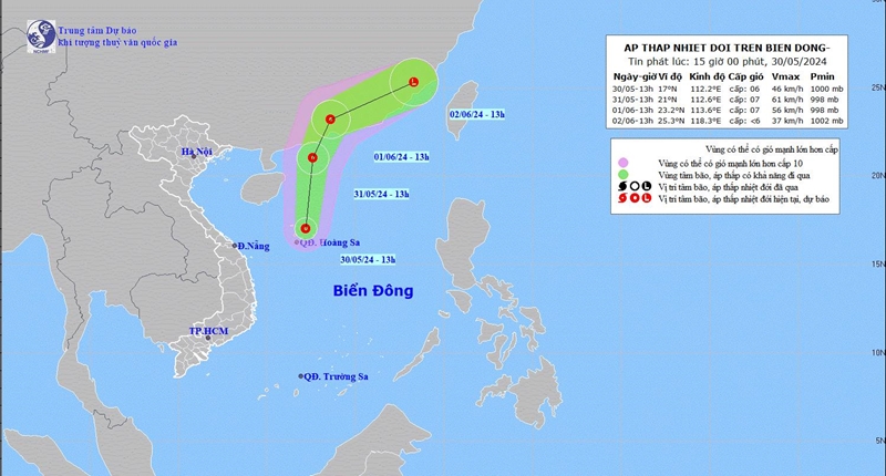
| The path of the first tropical depression in the East Sea during the 2024 storm and flood season. Photo: Center for Hydro-Meteorological Forecasting |
On the afternoon of May 30, Mr. Nguyen Van Huong, Head of the Weather Forecast Department, National Center for Hydro-Meteorological Forecasting, said that this afternoon a low pressure area in the Hoang Sa island district has strengthened into a tropical depression (ATNĐ). This is the first tropical depression to appear in the East Sea during this year's storm and flood season, a sign that the storm, flood, and natural disaster season at sea as well as on land has begun.
It is forecasted that in the next 24 hours, the tropical depression will move mainly in a North direction, at a speed of about 15km/h and will tend to strengthen. By 1:00 p.m. tomorrow, the tropical depression will be at about 21.0N-112.6E; over the sea of Guangdong province (China). After that, the tropical depression will move to the North-Northeast and will likely make landfall in the southern area of Guangdong province (China) and then gradually weaken.
According to the law of climate, at the beginning of the season, storms/tropical depressions are unlikely to move to the mainland of our country. With this first tropical depression of the season, meteorological experts say that at present, tropical depressions are unlikely to directly affect the mainland.
However, the tropical depression also causes the western area of the North East Sea (including the Hoang Sa archipelago) to have strong winds of level 6, then increasing to level 7, gusting to level 9, rough seas; waves 2.5-3.5m high, with the eastern sea area of the North East Sea and the middle of the East Sea, the sea area from Da Nang to Binh Thuan having strong southwest winds of level 5, sometimes level 6, gusting to level 7-8. Rough seas.
In addition, in the Gulf of Tonkin, the northern, central and southern areas of the East Sea (including the waters of the Hoang Sa and Truong Sa archipelagos), the waters from Quang Tri to Ca Mau , Ca Mau to Kien Giang and the Gulf of Thailand, there will be heavy showers and thunderstorms.
On land, from the evening of May 30 to the morning of May 31, the Southern region of the Northern Delta and Thanh Hoa to Quang Binh will have moderate rain, heavy rain and thunderstorms, locally very heavy rain with common rainfall of 40-70mm, in some places over 120mm.
In the afternoon and evening of May 30, the Central Highlands and the South will have scattered showers and thunderstorms, locally heavy rain with rainfall of 15-30mm, in some places over 50mm./.
Source: https://dangcongsan.vn/xa-hoi/xuat-hien-ap-thap-nhiet-doi-dau-tien-cua-mua-bao-lu-nam-2024-666098.html

![[Photo] General Secretary To Lam chairs a working session with the Central Internal Affairs Commission](https://vphoto.vietnam.vn/thumb/1200x675/vietnam/resource/IMAGE/2025/5/22/3b7790f499da45b2803d8ae253207ef1)


![[Photo] Prime Minister Pham Minh Chinh chairs the Government's special meeting on law-making in May](https://vphoto.vietnam.vn/thumb/1200x675/vietnam/resource/IMAGE/2025/5/22/1c880aae96fd4e0894abc47a46fe19ba)


![[Podcast] Week introducing more than 500 OCOP products in Hanoi](https://vphoto.vietnam.vn/thumb/402x226/vietnam/resource/IMAGE/2025/5/22/d144aac2416744718388dbae3260e7fd)


Comment (0)