
 |
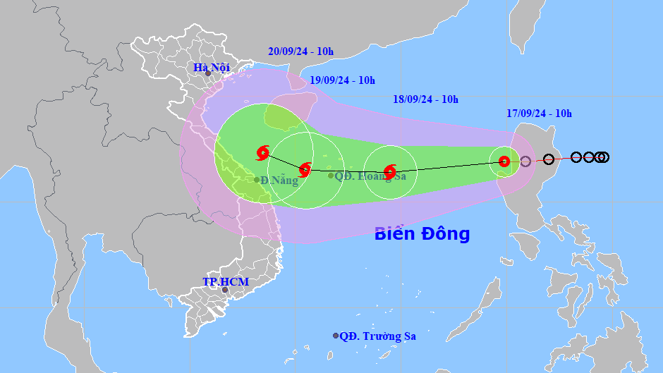
| Location and direction of the tropical depression. (Photo: TTKTTV) |
According to the National Center for Hydro-Meteorological Forecasting, this morning (September 17), a tropical depression entered the eastern sea area of the North East Sea.
At 10:00, the center of the tropical depression was at about 16.9 degrees North latitude; 119.9 degrees East longitude, in the eastern sea of the North East Sea. The strongest wind near the center of the tropical depression was level 7 (50 - 61 km/h), gusting to level 9; moving mainly in a westerly direction at a speed of about 20 km/h.
It is forecasted that in the next 24 to 48 hours, the tropical depression will likely strengthen into a storm, level 8 - 9 intensity, gusting to level 10 - 11.
Forecast at 10:00 on September 18, the center of the tropical depression was at about 16.4 degrees North latitude; 114.5 degrees East longitude, about 320km East of Hoang Sa archipelago. The strongest wind near the center of the tropical depression was at level 8, gusting to level 10; moving mainly in the West Southwest direction at a speed of about 20 - 25km/h, strengthening into a storm.
Forecast at 10:00 on September 19, the center of the tropical depression is at about 16.5 degrees North latitude; 110.5 degrees East longitude, in the area west of Hoang Sa archipelago. The strongest wind near the center of the tropical depression is level 9, gusting to level 11; moving mainly in the West direction at a speed of about 15 - 20 km/h. The affected area is the North East Sea (including Hoang Sa archipelago); the sea area from Quang Tri to Quang Ngai.
Warning in the next 48 to 72 hours, the storm is likely to change direction, moving in the West Northwest direction, traveling about 10km per hour.
It is forecasted that due to the impact of the tropical depression/storm, the eastern sea of the North East Sea will have strong winds of level 6 - 7, near the storm center level 8 (62 - 74km/h), gusts of level 10 (89 - 102km/h), rough seas.
The eastern sea area of the North East Sea has waves 2.0 - 4.0m high, increasing to 3.0 - 5.0m from the afternoon and night of September 17. Ships operating in the above-mentioned dangerous areas are likely to be affected by strong winds and large waves./.
Source: https://dangcongsan.vn/xa-hoi/ap-thap-nhiet-doi-giat-cap-9-da-tien-vao-bac-bien-dong-678111.html


![[Photo] Opening of the World Cultural Festival in Hanoi](https://vphoto.vietnam.vn/thumb/1200x675/vietnam/resource/IMAGE/2025/10/10/1760113426728_ndo_br_lehoi-khaimac-jpg.webp)
![[Photo] General Secretary attends the parade to celebrate the 80th anniversary of the founding of the Korean Workers' Party](https://vphoto.vietnam.vn/thumb/1200x675/vietnam/resource/IMAGE/2025/10/11/1760150039564_vna-potal-tong-bi-thu-du-le-duyet-binh-ky-niem-80-nam-thanh-lap-dang-lao-dong-trieu-tien-8331994-jpg.webp)
![[Photo] Ho Chi Minh City is brilliant with flags and flowers on the eve of the 1st Party Congress, term 2025-2030](https://vphoto.vietnam.vn/thumb/1200x675/vietnam/resource/IMAGE/2025/10/10/1760102923219_ndo_br_thiet-ke-chua-co-ten-43-png.webp)


Comment (0)