
 |
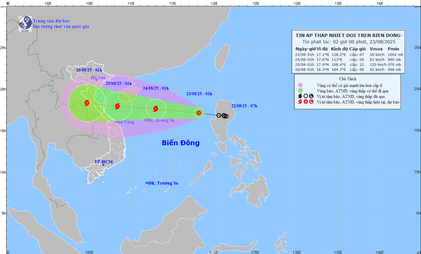
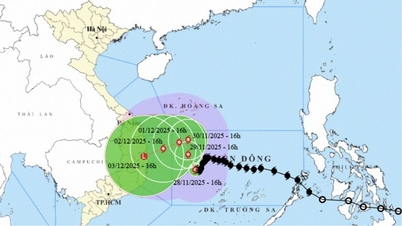
| Location and path of the tropical depression. (Source: National Center for Hydro-Meteorological Forecasting) |
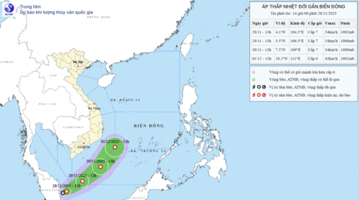
According to the National Center for Hydro-Meteorological Forecasting, at 1:00 a.m. on August 23, the center of the tropical depression was at about 17.1 degrees North latitude; 118.2 degrees East longitude, about 730km east of Hoang Sa special zone.
The strongest wind in the area near the center of the strong tropical depression is level 7 (50-61km/h), gusting to level 9; moving in the West Northwest direction at a speed of about 25km/h.
It is forecasted that by 1:00 a.m. on August 24, the tropical depression will strengthen into a storm moving in the West-Northwest direction at a speed of 20-25 km/h; in the sea northeast of Hoang Sa special zone, there will be wind force 9, gust 11.
The affected area is the North East Sea (including Hoang Sa special zone). Disaster risk level: level 3.
At 1:00 a.m. on August 25, the storm moved in the West Northwest direction, at a speed of about 20 km/h and continued to strengthen; in the sea area from Nghe An to Hue, the wind was 11-12, gusting 15. The affected area was the North East Sea (including Hoang Sa special zone), the sea area from Nghe An to Hue. Disaster risk level: level 3.
During the day and night of August 23, the North East Sea area (including Hoang Sa special zone) has winds of level 6-7, then increasing to level 8, near the storm center level 9-10, gusting to level 12. The sea is very rough. Waves are 3-6m high, near the center 4-6m. The Central East Sea area, the sea area from Khanh Hoa to Lam Dong, during the day level 5, sometimes level 6; at night increasing to level 6, gusting to level 7-8. Rough sea. Southwest wind, waves 2-3m high.
In addition, on the day and night of August 23, the North East Sea area (including Hoang Sa special zone) will have storms; the Central and South East Sea area (including Truong Sa special zone), the sea area from Gia Lai to Ca Mau, from Ca Mau to An Giang and the Gulf of Thailand will have scattered showers and thunderstorms. During thunderstorms, there is a possibility of tornadoes, strong gusts of wind of level 6-7 and waves over 2m high.
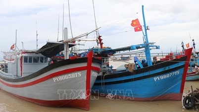
Risk level of natural disasters due to strong winds at sea: the sea area east of the North East Sea is level 3. All vessels operating in the above areas are at high risk of being affected by tornadoes, strong winds and big waves.
Risk of flash floods and landslides in Dien Bien and Tuyen Quang
In the past 6 hours (from 9:00 p.m. on August 22 to 3:00 a.m. on August 23), the areas of Dien Bien and Tuyen Quang provinces have had moderate to heavy rain such as: Pu Nhung1 61.2mm (Dien Bien); Cao Bo2 84.4mm, Thuong Son1 70.8mm (Tuyen Quang)...
In the next 3-6 hours, the above provinces will continue to have rain with common accumulated rainfall as follows: Dien Bien from 5-10mm, some places over 40mm; Tuyen Quang from 10-30mm, some places over 80mm.
In the next 6 hours, there is a risk of flash floods on small rivers and streams, landslides on steep slopes in the above provinces, especially in the communes/wards of Pu Nhung, Sang Nhe, Tua Thang (Dien Bien) and in Tuyen Quang province: Cao Bo, Hoang Su Phi, Tan Tien, Thuong Son; Bac Me, Bach Dich, Bach Ngoc, Ban May, Can Ty, Dong Tam, Giap Trung, Ho Thau, Lao Chai, Linh Ho, Lung Tam, Mau Due, Minh Son, Minh Tan, Nam Dan, Nam Dich, Nghia Thuan, Ngoc Duong, Ha Giang 1, Ha Giang 2, Pa Vay Su, Phu Linh, Po Ly Ngai, Quan Ba, Quang Nguyen, Tan Quang, Thang Mo, Thang Tin, Thanh Thuy, Thuan Hoa, Trung Thinh, Tung Ba, Tung Vai, Vi Xuyen, Viet Lam, Xin Man, Yen Minh.
Flash floods and landslides can have very negative impacts on the environment, threaten people's lives; cause local traffic congestion, affect the movement of vehicles; destroy civil and economic works, causing damage to production and socio-economic activities.
Specific weather in each region
In the Northwest, it is cloudy with scattered showers and thunderstorms, with some places experiencing heavy rain (rain concentrated in the early morning, late afternoon and night). Light wind. During thunderstorms, there is a possibility of tornadoes, lightning, hail and strong gusts of wind. Temperatures range from 23-26 degrees Celsius, with some places below 23 degrees Celsius; highest from 30-33 degrees Celsius, with some places above 33 degrees Celsius, with Lai Chau-Dien Bien at 27-30 degrees Celsius.
The Northeast region has scattered showers and thunderstorms, especially in mountainous areas, with some places having heavy rain (rain concentrated in the early morning, late afternoon and night). Light wind, from early tomorrow morning the Northeast to North wind level 2-3. During thunderstorms there is a possibility of tornadoes, lightning, hail and strong gusts of wind. Temperatures range from 24-27 degrees Celsius, some places below 24 degrees Celsius; highest from 30-33 degrees Celsius, some places above 34 degrees Celsius.
From Thanh Hoa to Hue, sunny days, scattered showers and thunderstorms in the afternoon and evening, scattered showers and thunderstorms at night. Light wind. During thunderstorms, there is a possibility of tornadoes, lightning, hail and strong gusts of wind. Temperatures range from 24-27 degrees Celsius, highest from 31-34 degrees Celsius, some places above 34 degrees Celsius.
The South Central Coast has scattered showers and thunderstorms, especially in the evening. Southwest wind force 2-3. During thunderstorms, there is a possibility of tornadoes, lightning, hail and strong gusts of wind. Temperatures range from 23-26 degrees Celsius, highest from 31-34 degrees Celsius, some places above 34 degrees Celsius.
The Central Highlands has scattered showers and thunderstorms, with scattered showers and thunderstorms in the late afternoon and evening, and locally heavy rain. Southwest wind level 2-3. There is a possibility of tornadoes, lightning, hail, and strong gusts of wind during thunderstorms. Temperatures range from 20-23 degrees Celsius, with the highest at 28-31 degrees Celsius.
The South has scattered showers and thunderstorms, with scattered showers and thunderstorms in the late afternoon and evening, and locally heavy rain. Southwest wind level 2-3. There is a possibility of tornadoes, lightning, hail, and strong gusts of wind during thunderstorms. Temperatures range from 23-26 degrees Celsius, with the highest at 30-33 degrees Celsius, with some places above 33 degrees Celsius.
Hanoi City has intermittent sunshine during the day, with showers and thunderstorms in some places in the late afternoon and evening. Light wind, from early tomorrow morning the Northeast to North wind level 2-3. During thunderstorms there is a possibility of tornadoes, lightning and strong gusts of wind. Temperatures range from 25-27 degrees Celsius, highest at 32-34 degrees Celsius.
Ho Chi Minh City has scattered showers and thunderstorms, especially in the late afternoon and evening with scattered showers and thunderstorms, locally heavy rain. Southwest wind level 2-3. During thunderstorms, there is a possibility of tornadoes, lightning, hail and strong gusts of wind. Temperatures range from 23-25 degrees Celsius, highest at 32-34 degrees Celsius./.
Source: https://huengaynay.vn/chinh-tri-xa-hoi/ap-thap-nhiet-doi-tien-vao-bien-dong-kha-nang-manh-len-thanh-bao-157013.html


Comment (0)