
Specifically, at 1 p.m. on November 26, storm No. 15 was about 280 km east-northeast of Song Tu Tay Island. The strongest wind near the storm center was level 9 (75-88 km/h), gusting to level 11, moving west-northwest at a speed of about 20 km/h and likely to strengthen further.
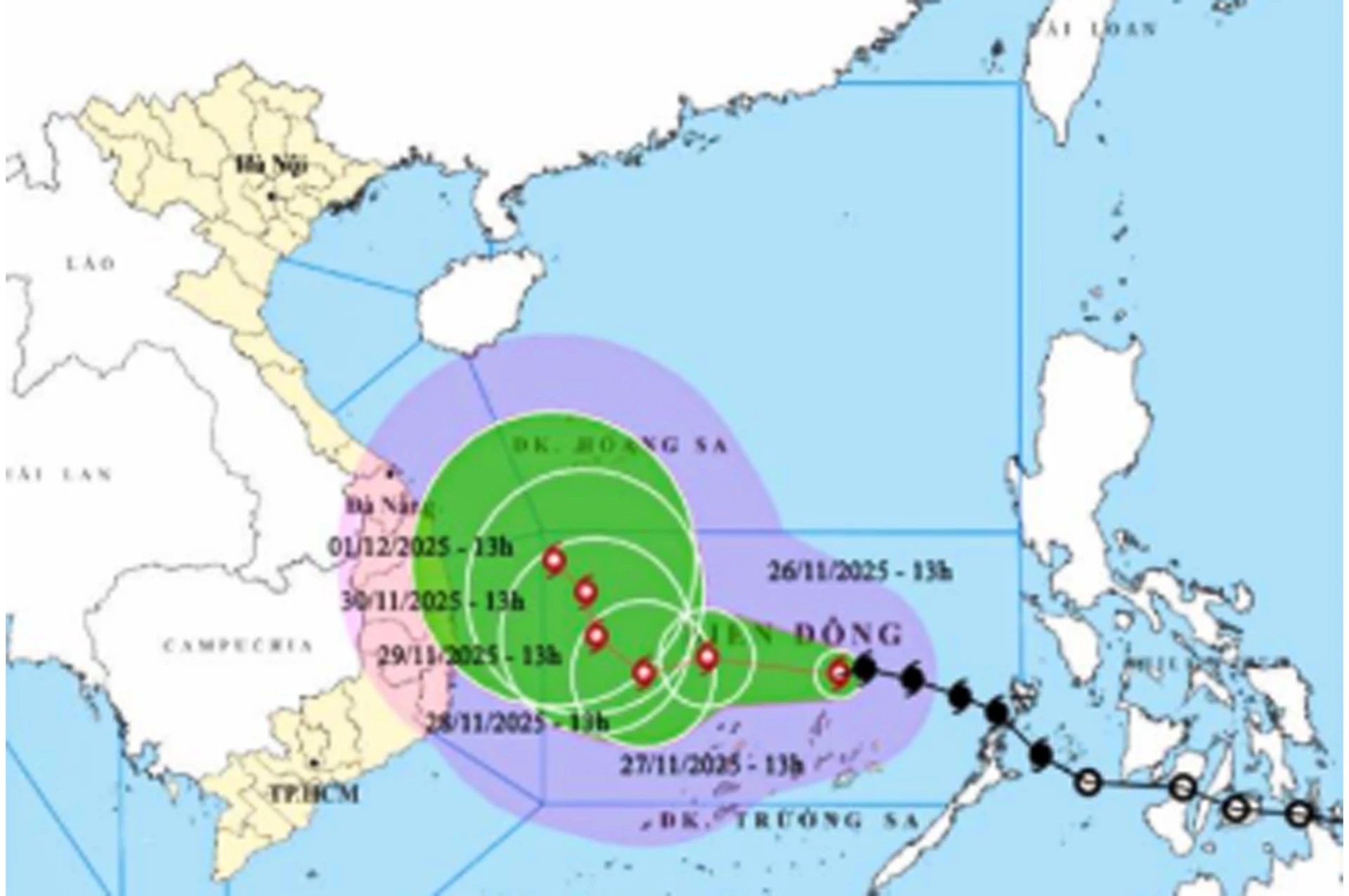 |
| Location and forecast direction of storm number 15. |
It is forecasted that by 1 p.m. on November 27, the storm will be in the middle of the East Sea, about 150 km north of Song Tu Tay Island, moving in the West-Northwest direction at a speed of about 10 km/hour, wind force level 11, gust level 14. By 1 p.m. on November 28, the storm will be in the middle of the East Sea, about 200 km northwest of Song Tu Tay Island, wind force level 11, gust level 14 and moving in the West-Southwest direction at a speed of about 5 km/hour.
Due to the storm's influence, the sea off Khanh Hoa province has strong northeast winds of level 6-7, gusting to level 8-9; waves 4-6m high, rough seas. The sea in Truong Sa special economic zone has strong winds of level 6-7; in the North, strong winds of level 7-8, near the storm's eye, strong winds of level 9-11, gusting to level 14; waves 4-6m high, near the storm's eye, 7-9m, rough seas. Ships operating in the above-mentioned dangerous areas are likely to be affected by storms, whirlwinds, strong winds, and big waves.
H.D
Source: https://baokhanhhoa.vn/xa-hoi/202511/bao-di-chuyen-cham-tren-vung-bien-truong-sa-75b0f9e/
![[Photo] Close-up of heavy damage at the school located on the banks of the Ban Thach River](/_next/image?url=https%3A%2F%2Fvphoto.vietnam.vn%2Fthumb%2F1200x675%2Fvietnam%2Fresource%2FIMAGE%2F2025%2F11%2F26%2F1764152130492_ndo_bl_img-8188-8805-jpg.webp&w=3840&q=75)


![[Photo] VinUni students' emotions are sublimated with "Homeland in the Heart: The Concert Film"](/_next/image?url=https%3A%2F%2Fvphoto.vietnam.vn%2Fthumb%2F1200x675%2Fvietnam%2Fresource%2FIMAGE%2F2025%2F11%2F26%2F1764174931822_10-3878-jpg.webp&w=3840&q=75)


![[Photo] Opening of the 28th Session of the Hanoi People's Council](https://vphoto.vietnam.vn/thumb/402x226/vietnam/resource/IMAGE/2025/11/26/1764155991133_image.jpeg)


Comment (0)