

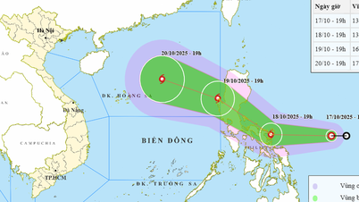
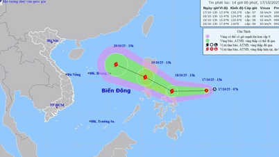
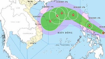
The path of typhoon Fengshen.
On the morning of October 18, the National Center for Hydro-Meteorological Forecasting issued its first announcement on storm Fengshen moving into the East Sea. According to the forecast, early on the morning of October 18, the tropical depression in the sea east of the Philippines intensified into a storm, becoming the 24th storm in the Northwest Pacific region, internationally named Fengshen (in Chinese meaning "god of wind").
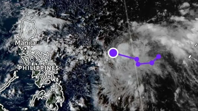
At 7:00 a.m. this morning, the center of storm Fengshen was at about 13.1 degrees north latitude; 126.5 degrees east longitude, in the sea east of central Philippines, with a strong intensity of level 8 (62 km/h -74 km/h), gusting to level 10.
It is forecasted that on the morning of October 19, storm Fengshen will make landfall on Luzon Island (Philippines), then enter the East Sea, becoming storm No. 12. When moving into the East Sea, the storm will mainly move in the West-Northwest direction and is expected to reach its strongest intensity of level 11, gusting to level 13 around October 22 in the northern area of Hoang Sa special zone. However, due to the impact of cold air from the West and North, storm No. 12 will gradually weaken and most likely become a tropical depression before directly affecting the central provinces.
Although the possibility of the storm maintaining its strong intensity when making landfall in the central region is not high, the storm circulation combined with cold air will cause strong winds of level 6-8, waves of 3m-4m high in the North Sea and the middle of the East Sea, the Gulf of Tonkin and the sea area from Quang Tri to Quang Ngai in the coming days.
Notably, from October 23 to 26, the area from Ha Tinh to Quang Ngai is likely to experience moderate to heavy rain over a wide area, due to the impact of post-storm circulation No. 12 combined with cold air. The intensity and extent of rain will depend on the interaction between the storm and cold air: if the storm arrives first, the rain can be very heavy; if cold air arrives first, the rain will not be too heavy.
According to Nhan Dan Newspaper
Source: https://baotuyenquang.com.vn/xa-hoi/202510/bao-fengshen-vao-bien-dong-mien-trung-doi-mat-gio-manh-mua-lon-11c1aa1/


![[Photo] Closing ceremony of the 18th Congress of Hanoi Party Committee](https://vphoto.vietnam.vn/thumb/1200x675/vietnam/resource/IMAGE/2025/10/17/1760704850107_ndo_br_1-jpg.webp)


![[Photo] Nhan Dan Newspaper launches “Fatherland in the Heart: The Concert Film”](https://vphoto.vietnam.vn/thumb/1200x675/vietnam/resource/IMAGE/2025/10/16/1760622132545_thiet-ke-chua-co-ten-36-png.webp)


![[Infographic] Organizing to collect public opinions on draft documents to be submitted to the 14th National Party Congress](https://vphoto.vietnam.vn/thumb/402x226/vietnam/resource/IMAGE/2025/10/18/1760774470262_anh-bia-copy.jpeg)


Comment (0)