
Storm No. 1 zigzag path, wide circulation
On the morning of June 11, the tropical depression (TLD) in the area east of Hoang Sa archipelago strengthened into a storm - the number 1 storm in the East Sea in 2025, internationally named Wutip. The storm has the strongest wind near the center at level 8 (62 - 74 km/h), gusting to level 10.
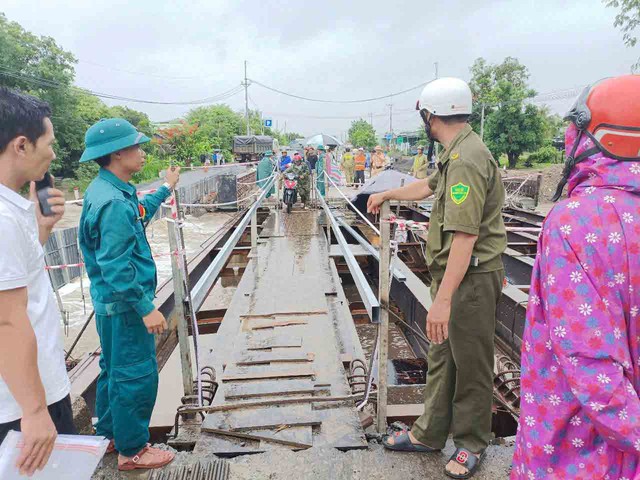
Traffic on National Highway 25 through Ayun Ha Commune, Phu Thien District, Gia Lai Province is congested, only motorbikes and pedestrians can move.
PHOTO: TRAN HIEU
If we look at the process of formation and development from the low pressure area to the tropical depression, its direction of movement is constantly changing. This shows that the storm is very complex and unpredictable, as initially predicted by the National Center for Hydro-Meteorological Forecasting (NCHMF). According to experts, the influence of the storm creates a wide circulation and the strong development of the southwest monsoon, causing heavy rain in many areas on the mainland of our country.
In Ho Chi Minh City, in recent days, dark clouds have frequently covered the sky; accompanied by thunderstorms, howling winds and heavy rain in many areas, causing many roads to be severely flooded. In the Central region, especially in Hue City, from the night of June 10 to this morning, many people living on the city's central roads were surprised when the heavy rain at the beginning of summer caused flooding and traffic paralysis due to heavy rain during the night. The average rainfall was 25 - 100 mm; in some areas, the rainfall was 100 - 180 mm. In the northern provinces, heavy rain also occurred in many localities, especially in mountainous provinces and cities. Prolonged heavy rain caused the water level of the Red River to rise, with a large flow rate. Therefore, the functional forces of Phu Tho province had to temporarily cut off the Phong Chau pontoon bridge to ensure safety.
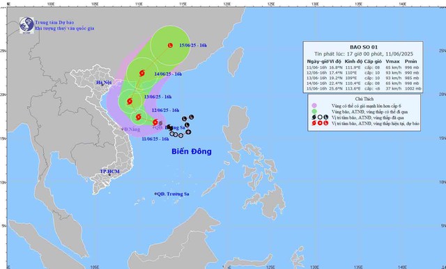
By the afternoon of June 11, NCHMF said: The eye of the storm is at 16.8 degrees north latitude and 111.9 degrees east longitude, in the Hoang Sa archipelago. The storm intensity is level 8 (62 - 74 km/h), gusting to level 10. The storm is moving west-northwest at a speed of about 15 km/h. Due to the influence of the storm, the western part of the northern East Sea (including the Hoang Sa archipelago) has strong winds of level 7 - 8, the area near the eye of the storm has winds of level 9 - 10, gusting to level 13. Waves are 3 - 5 m high; the area near the eye of the storm is 4 - 6 m; the sea is very rough. The sea off the coast from Quang Tri to Quang Ngai from the night of June 11 has winds gradually increasing to level 6 - 8, the area near the eye of the storm is level 9 - 10, gusting to level 13. Waves are 3 - 5 m high; the sea is very rough. From June 12, the Gulf of Tonkin will have winds gradually increasing to level 6-7, near the storm center level 8-9, gusting to level 11; waves 2-4 m high; very rough seas.
In addition, due to the influence of storm No. 1, the central region has heavy to very heavy rain with common rainfall from 100 - 250 mm, some places over 450 mm. The northern Central Highlands has moderate rain, heavy rain and thunderstorms, locally some places have very heavy rain with common rainfall from 70 - 150 mm, some places over 200 mm. The southern Central Highlands and the South have moderate rain, heavy rain and thunderstorms, locally some places have very heavy rain with rainfall from 30 - 70 mm, some places over 150 mm. The south central region has scattered showers and thunderstorms, locally some places have heavy rain with rainfall from 15 - 30 mm, some places over 50 mm.
Storm forecast (in the next 24 - 72 hours)
PHOTO: NCHMF
People in the Central region need to be alert to the risk of localized heavy rain of over 200 mm in 6 hours. During thunderstorms, there is a risk of tornadoes, lightning, hail, strong gusts of wind; flash floods on small rivers and streams, landslides on steep slopes and inundation in low-lying areas and urban areas. In particular, due to the impact of heavy rain, there is a possibility of a flood on rivers from Quang Binh to Quang Ngai. During this flood, the peak water level is likely to reach alert level 1 and above alert level 1. There is a high risk of flooding in low-lying areas along rivers, flash floods and landslides on steep slopes in mountainous areas of the provinces from Quang Binh to Quang Ngai.
By the afternoon of June 14, storm No. 1 will weaken over southern China; rain will also decrease in mainland areas of our country.
Forecast of provinces with heavy rain in storm No. 1
What will the weather be like in the next 30 days?
Immediately after the heavy rain ended, widespread heat waves appeared again. NCHMF announced that from June 14 to 16, there is a possibility of widespread heat waves. From the night of June 16 to the end of the sunny period, there will be hot weather in some places, with showers and thunderstorms in some places in the evening and at night, especially in mountainous and midland areas, there will be scattered showers and thunderstorms.
The North and Central regions will have widespread heat from June 14 to the end of the period. The South Central region will have scattered showers and thunderstorms in the evening and at night, and sunny days with some hot weather. The Central Highlands and the South will have scattered showers and thunderstorms in the evening and at night.
In the medium-term forecast until July 10, there is a possibility of 1-2 storms appearing in the East Sea and they may affect the mainland of our country. Therefore, during this period, the Northern and North Central regions may experience some widespread heavy rains. In the Central Highlands and the South, due to the influence of the southwest monsoon with medium to strong intensity, there will be many days of thunderstorms, some days with heavy to very heavy rain. Be especially careful of localized heavy rains that can cause flooding, inundation in low-lying areas and landslides in mountainous areas.
Notably, in the Northern and Central regions, there may be some days of intense and especially intense heat. In the Central region, there is still a possibility of little rain and more heat, especially in the Central and South Central regions, leading to drought, water shortages and a very high risk of fire and explosion.
Localities ready to respond to storm No. 1
Faced with the complex developments of storm No. 1, Quang Ngai province has urgently deployed response measures, especially calling on ships operating at sea to quickly find safe shelter. The Border Guard Command of Quang Ngai province said that the unit has proactively sent urgent notices to all vessels operating in the East Sea.
The People's Committee of Quang Ngai province has also directed units to urgently notify and call on ships operating at sea to know the location, direction of movement and developments of storm No. 1 to proactively avoid it; request ships in the storm's dangerous area not to be subjective, urgently move and take shelter immediately to ensure safety.
There are currently 2 Quang Ngai fishing boats with 16 fishermen in the dangerous waters of storm No. 1. Quang Ngai Border Guard is actively maintaining contact and guiding these boats to quickly move away from the dangerous area and find safe shelter.
On June 11, Colonel Phan Van Thi, Deputy Commander of the Quang Nam Provincial Border Guard Command, said that the unit had just dispatched ship BP-43.9801 with 7 officers and soldiers of Border Guard Squadron 2 from Tam Hiep Port (Nui Thanh District, Quang Nam) to deploy support and rescue work for fishing boats in distress at sea. According to the Quang Nam Provincial Border Guard Command, at 9:10 a.m. the same day, fishing boat QNa 92954-TS of fishermen in Dien Duong Ward (Dien Ban Town, Quang Nam) was fishing at a location about 40 nautical miles east of An Hoa Cape when the engine broke down and was at risk of sinking due to the impact of big waves and strong winds of storm No. 1.
Hai Phong - Manh Cuong
Hundreds of households isolated, traffic cut off
Due to the impact of storm No. 1, heavy rain lasting from the evening of June 10-11 caused serious flooding in many localities in Gia Lai province, isolating hundreds of households and cutting off traffic.
In Kim Tan commune, Ia Pa district, Mr. Le Huu Hung, Chairman of the People's Committee of the commune, informed: The overflowing culvert across Dak Pi Hao stream in Mo Nang 2 village was about 2 meters deep and over 80 meters long, completely isolating all 319 households in the village. The local government has sent forces to be on duty at both ends of the flooded area to ensure the safety of the people. A similar situation also occurred in Bi Gia village (Po To commune, Ia Pa district) with more than 200 households isolated due to the deep overflowing culvert.
In particular, National Highway 25 through Plei Lok Bridge, Ayun Ha Commune, Phu Thien District was deeply flooded, causing traffic congestion from Phu Thien District to Ayun Pa Town. Hundreds of cars had to stop on both sides of the bridge and could not move because the temporary replacement bridge was flooded.
According to the report of the Department of Agriculture and Environment of Ia Pa district, heavy rains have flooded 4 overflows, collapsed 120m of Vo Thi Sau Primary School fence and flooded many crop areas. Authorities are continuing to count the damage and advise people to absolutely not go through flooded areas to ensure safety.
Tran Hieu
Source: https://thanhnien.vn/bao-so-1-gay-mua-lon-khap-noi-18525061122455446.htm


Comment (0)