

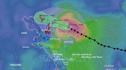
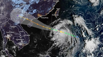
The National Center for Hydro-Meteorological Forecasting said that storm No. 11 is in the East Northeast region of Hainan Island (China) with maintained wind strength and speed. The storm continues to move in the West Northwest direction and this evening (October 5) is expected to directly affect the North East Sea and the North Gulf of Tonkin.
At 5:00 a.m. on October 5, the center of the storm was at approximately 19.9 degrees North latitude; 112.0 degrees East longitude, approximately 110 km East Northeast of Hainan Island (China). The strongest wind near the center of the storm was level 12 (118-133 km/h), gusting to level 15, moving in a West Northwest direction at approximately 25 km/h.
Forecast, by 4pm on October 5, the storm will be in the western part of Leizhou Peninsula (China), about 250km East Southeast of Quang Ninh , with strong winds of level 12, gusts of level 15; moving in the West Northwest direction at a speed of 20-25km/hour. The affected area is the northwestern sea area of the North East Sea and the northern Gulf of Tonkin. Disaster risk level 3.
By 4:00 a.m. on October 6, the storm was on the coast of Quang Ninh - Hai Phong provinces, with wind speed reduced to level 9, gusting to level 12; moving in the West Northwest direction at a speed of about 20 km/hour.
The affected area includes the Northwestern sea area of the North East Sea, the North Gulf of Tonkin and the coastal mainland area from Quang Ninh to Hung Yen . Disaster risk level 3.
By 4 p.m. on October 6, the storm had moved into the northern mountainous region of the North, with winds reduced to level 6, gusting to level 8; moving in the West Northwest direction at a speed of about 20 km/hour.

The affected area includes the northern Gulf of Tonkin, the coastal mainland from Quang Ninh to Hung Yen and Lang Son province. Disaster risk level 3.
By 4:00 a.m. on October 7, the storm had moved into the mountainous region in the west of the North and weakened into a low pressure area. The center of the low pressure was at about 22.8 degrees North latitude, 103.8 degrees East longitude; the strongest wind was below level 6.
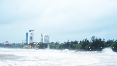
Due to the influence of the storm, the Northwestern sea area of the North East Sea has strong winds of level 8-10, the area near the eye of the storm has level 11-13, gusts of level 15-16, waves 4-6m high, the area near the eye of the storm has 6-8m, the sea is very rough (extremely destructive, extremely strong waves. Sinking large tonnage ships).
From the afternoon of October 5, the sea area east of the Northern Gulf of Tonkin (including Bach Long Vi special zone) has winds gradually increasing to level 6-7, then increasing to level 8-9. From the evening of October 5, the Northern Gulf of Tonkin area (including Bach Long Vi special zone, Van Don, Co To, Cat Hai and Hon Dau island) has strong winds of level 8-9, waves 2-4m high, the area near the storm center has levels 10-11, gusts of level 14, waves 3-5m high, rough seas (very dangerous for ships).
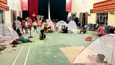
Coastal areas and islands in Quang Ninh - Hai Phong provinces will have storm surges of 0.4-0.6m. Beware of flooding in low-lying coastal areas and river mouths due to surges and big waves from the afternoon and evening of October 5th.

Weather warning at sea, coastal mainland during the storm is extremely dangerous, unsafe for any vehicle, construction operating in the danger zone such as cruise ships, passenger ships, transport ships, cages, rafts, aquaculture areas, dykes, embankments, coastal routes. Vehicles are highly likely to capsize, be destroyed; flooded due to strong winds, big waves and rising sea levels.
On land, from the night of October 5, on land in coastal areas from Quang Ninh to Hung Yen, winds will gradually increase to level 6-7, near the storm center, level 8-9, gusting to level 10-11.
Inland areas in the Northeast have strong winds of level 4-5, in some places level 6, gusting to level 7-8.

In addition, from the night of October 5 to the end of the night of October 7, in the mountainous and midland areas of the North, there will be heavy rain, with rainfall ranging from 150-250mm, and locally very heavy rain of over 400mm. Warning of the risk of heavy rain (over 150mm/3 hours).
In the Northern Delta region, Thanh Hoa has moderate to heavy rain with common rainfall of 70-150mm, locally very heavy rain over 200mm.
Hanoi area is less likely to be affected by storms. It is forecasted that from early morning of October 6 to the end of October 7, there will be moderate to heavy rain, with common rainfall of 70-120mm, locally over 150mm.
Due to the influence of the wide storm circulation, it is necessary to guard against the risk of thunderstorms, tornadoes and strong gusts of wind both before and during the storm's landfall.
Specific weather in each region
The Northwest region is cloudy, sunny during the day, with scattered showers and thunderstorms. During thunderstorms, there is a possibility of tornadoes, lightning and strong gusts of wind. The lowest temperature is from 23-26 degrees Celsius, in some places below 22 degrees Celsius; the highest is from 31-34 degrees Celsius.
In the Northeast, there will be showers and thunderstorms in some places during the day; at night there will be rain, moderate rain, locally heavy rain and thunderstorms, especially in mountainous and midland areas, there will be heavy rain, some places will have very heavy rain. Northwest to North wind level 2-3; especially in coastal areas from Quang Ninh to Hung Yen, the wind will gradually increase to level 6-7 at night, gusting to level 8-9.
During thunderstorms, there is a possibility of tornadoes, lightning and strong gusts of wind. The lowest temperature is from 23-26 degrees Celsius, in mountainous areas it is below 23 degrees Celsius; the highest is from 31-34 degrees Celsius, in some places it is above 34 degrees Celsius.
From Thanh Hoa to Thua Thien Hue, it will be sunny with scattered showers and thunderstorms. West to Southwest winds at level 2-3. During thunderstorms, there is a possibility of tornadoes, lightning, and strong gusts of wind. The lowest temperature will be from 25-28 degrees Celsius; the highest will be from 31-34 degrees Celsius.
The South Central Coast region will also have sunny days with scattered showers and thunderstorms. Southwesterly winds at level 2-3. During thunderstorms, there is a possibility of tornadoes, lightning, and strong gusts of wind. The lowest temperature will be from 24-27 degrees Celsius; the highest will be from 31-34 degrees Celsius.
The Central Highlands has scattered showers and thunderstorms; in the late afternoon and evening, there will be scattered showers and thunderstorms. Southwest wind level 2-3. During thunderstorms, there is a possibility of tornadoes, lightning, and strong gusts of wind. Lowest temperature from 19-22 degrees Celsius; highest from 29-32 degrees Celsius.
Southern region has scattered showers and thunderstorms during the day; scattered showers and thunderstorms in the afternoon and evening. Southwest wind level 2-3. During thunderstorms, there is a possibility of tornadoes, lightning and strong gusts of wind. Lowest temperature from 24-27 degrees Celsius; highest from 31-34 degrees Celsius.
Hanoi is cloudy, sunny during the day, with rain at night, moderate rain, locally heavy rain and scattered thunderstorms. Northwest to North wind level 2-3. During thunderstorms, there is a possibility of tornadoes, lightning and strong gusts of wind. Lowest temperature from 24-26 degrees Celsius, highest from 32-34 degrees Celsius.
Ho Chi Minh City has scattered showers and thunderstorms during the day; scattered showers and thunderstorms in the afternoon and evening. Southwest wind level 2-3. During thunderstorms, there is a possibility of tornadoes, lightning, and strong gusts of wind. Lowest temperature from 24-26 degrees Celsius; highest from 32-34 degrees Celsius.
Source: https://www.sggp.org.vn/bao-so-11-sap-vao-vinh-bac-bo-canh-bao-mua-lon-dien-rong-post816406.html
![[Photo] Prime Minister Pham Minh Chinh launched a peak emulation campaign to achieve achievements in celebration of the 14th National Party Congress](https://vphoto.vietnam.vn/thumb/1200x675/vietnam/resource/IMAGE/2025/10/5/8869ec5cdbc740f58fbf2ae73f065076)

![[Photo] Prime Minister Pham Minh Chinh chairs the Government's online conference with localities](https://vphoto.vietnam.vn/thumb/1200x675/vietnam/resource/IMAGE/2025/10/5/264793cfb4404c63a701d235ff43e1bd)


![[VIDEO] Summary of Petrovietnam's 50th Anniversary Ceremony](https://vphoto.vietnam.vn/thumb/402x226/vietnam/resource/IMAGE/2025/10/4/abe133bdb8114793a16d4fe3e5bd0f12)

![[VIDEO] GENERAL SECRETARY TO LAM AWARDS PETROVIETNAM 8 GOLDEN WORDS: "PIONEER - EXCELLENT - SUSTAINABLE - GLOBAL"](https://vphoto.vietnam.vn/thumb/402x226/vietnam/resource/IMAGE/2025/7/23/c2fdb48863e846cfa9fb8e6ea9cf44e7)


Comment (0)