

Entering the Gulf of Tonkin this morning, the fifth storm in the South China Sea is forecast to reach its peak speed of nearly 88 km/h (level 9) tomorrow, before weakening into a tropical depression.
According to the National Center for Meteorological and Hydrological Forecasting, at 7:00 AM, the center of Typhoon Sanba (the fifth typhoon in the world) was located in the southeast of the Gulf of Tonkin, with maximum wind speeds of 74 km/h, level 8. The typhoon continues to move north-northwest at a speed of 10 km/h and may strengthen further, reaching maximum wind speeds of level 8-9 in the northern Gulf of Tonkin by 7:00 AM tomorrow.
On October 21st, due to interaction with cold air from the north, the storm turned south, weakened into a tropical depression and a low-pressure area in the Gulf of Tonkin, with maximum wind speeds below level 6.
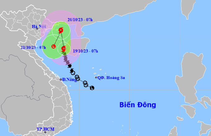
Forecast of the path and affected areas of Typhoon Sanba at 7:00 AM on October 19th. Photo: NCHMF
Japanese and Hong Kong weather stations predict the storm will reach its peak speed of around 85-88 km/h tomorrow morning while in the middle of the Gulf of Tonkin, then turn south and rapidly weaken. The predicted path differs slightly; while Vietnamese and Hong Kong stations predict the storm will approach Hainan Island (China), the US Navy, Japan, and TSR (Typhoon Surveillance Service) of the University of London predict it will maintain a distance from the island.
Due to the influence of the storm, the Gulf of Tonkin (including Co To and Bach Long Vi islands) and the sea area of Quang Tri will experience increasingly strong winds from level 6 to 9, gusting to level 11, with waves 2-4 meters high, later increasing to 3-5 meters. From the night of October 19th, the coastal areas of Quang Ninh and Thai Binh will experience increasingly strong winds up to level 6, gusting to levels 7-8.
On land, from tonight to tomorrow night, the southern delta, northeastern part of Northern Vietnam, and North Central Vietnam will receive 15-30 mm of rain, with some areas receiving over 60 mm. This amount of rainfall is much lower than previous forecasts, due to the storm moving away from the mainland. Rainfall in Central Vietnam will decrease rapidly.
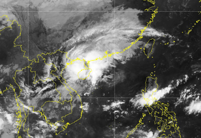
Satellite imagery shows the storm's center has moved away from the Vietnamese mainland and is approaching Hainan Island (China). Above, a cold front is moving in. (Image: NCHMF)
Sanba is the fifth typhoon in the South China Sea this year. The two previous typhoons, Koinu and Saola, entered the South China Sea and headed north, not affecting Vietnam. It is predicted that another typhoon or tropical depression may appear in October.
Yesterday afternoon, the National Steering Committee for Disaster Prevention and Control requested coastal provinces from Quang Ninh to Binh Dinh to closely monitor the storm's developments, count the number of boats and ships; coordinate with the Border Guard Command and the Fisheries Department to guide boats and ships in anchoring, sheltering, protecting cages, watchtowers, and aquaculture areas, and proactively prohibiting sea travel depending on the storm's developments.
On the night of the 16th and early morning of the 17th, two squid fishing boats near the Spratly Islands were sunk by waves, resulting in two deaths and 13 people still missing.
Source link


![[Photo] Coc Ly market bustling on the eve of Tet](https://vphoto.vietnam.vn/thumb/402x226/vietnam/resource/IMAGE/2026/02/14/1771062261424_baolaocai-br_img-6457-jpg.webp)


Comment (0)