
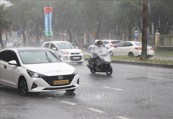
Cold weather in the North is likely to appear from the second half of December.
According to Dr. Hoang Duc Cuong, around October 2025, cold air tends to increase in intensity and frequency. Cold air is likely to be active in November - December 2025, severe cold in the North is likely to appear from the second half of December (equivalent to the average of many years).
Along with that, from October to December 2025, storms and tropical depressions operating in the East Sea and affecting our country are likely to be at a higher level than the average of many years (average of many years in the East Sea 4.5 storms, making landfall 1.9 storms); heavy rains are likely to appear in the Central region.
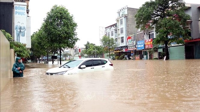
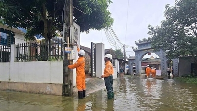
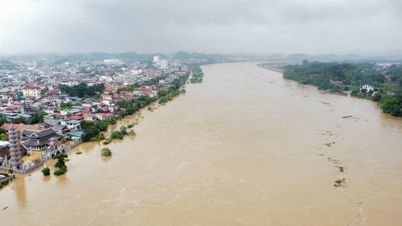
Regarding the flood situation on rivers, Mr. Hoang Duc Cuong said that from Quang Tri to Khanh Hoa and Lam Dong: the flood peak is generally at alert level 2 - alert level 3, in some places exceeding alert level 3. Large floods are likely to be concentrated in October - November and there is a possibility of late floods appearing at the end of the year coinciding with the water accumulation period of the inter-reservoir operation processes of rivers in the Central region. The risk of flooding in urban areas and large cities continues to occur due to the impact of local heavy rains. Flash floods and landslides are at high risk in mountainous provinces.
The flood peak in 2025 at the headwaters of the Mekong River at Tan Chau station, Chau Doc is at alert level 1 - alert level 2. In the Mekong Delta region, in the first months of the dry season of 2025-2026 (from December 2025 to March 2026), the total rainfall in the basin is forecast to be approximately equal to and higher than the average of many years, the total flow to the Mekong Delta is likely to be equivalent to the average of many years and equivalent to the same period in 2024-2025, 30-40% higher than the same period in 2019-2020.
During the dry season months (from January to May 2026), in the Mekong Delta, heat waves will appear late, the intensity of heat waves will not be as severe, lasting as many days as in 2024 and there is a high possibility of unseasonal rains appearing in the first months of 2026.
Saline intrusion in the Mekong Delta in the first months of the 2025-2026 dry season will be at the same level as the 2024-2025 dry season and lower than the dry seasons of 2015-2016 and 2019-2020.
The ENSO phenomenon (including El Nino and La Nina phenomena, the anomalous warming and cooling of surface water in the central and eastern equatorial Pacific ) is likely to remain neutral and inclined towards a cold phase, but has not yet reached a La Nina cycle.
The South is likely to experience unseasonal rains.
Referring to the climate trend from January to March 2026, Deputy Head of Climate Forecast Department, National Center for Hydro-Meteorological Forecasting Nguyen Duc Hoa said that in the first months of 2026, the Southern region is likely to experience unseasonal rains.
From January to March, total rainfall in the Northern region and provinces and cities from Thanh Hoa to Hue is generally approximately the same as the average of many years; the area from Da Nang to Lam Dong and the Southern region is 10-30mm higher than the average of many years in the same period. Specifically, in the Northern region, in January - February, total rainfall is generally from 20-40mm/month, higher in some places; in March, total rainfall is generally from 40-70mm/month, higher in some places.
In the Central region, January - February, total rainfall from Thanh Hoa to Hue is generally from 20-50mm/month, higher in some places; in the South Central Coast region, it is generally from 50-100mm/month, higher in some places; in the Central Highlands region, in January, it is generally from 5-20mm, higher in some places; in February, it is generally 20-50mm, higher in some places; in March, total rainfall is generally from 40-70mm, higher in some places.
Total rainfall in January - February in the South is generally from 20-40mm/month, higher in some places; total rainfall in March is generally from 30-70mm, higher in some places.
In January - March, total rainfall in the upper and middle reaches of the Mekong River is generally at a level approximately equal to the average of many years. In March 2026, total rainfall in the upper reaches is generally 10 - 20% lower than the average of many years in the same period. In January, total rainfall in the lower reaches is generally 5 - 15% higher, in February - March 2026, total rainfall is generally 10 - 30% higher than the average of many years in the same period.
Regarding storms and tropical depressions, from January to March, there is little possibility of storms and tropical depressions appearing in the East Sea (the average number of storms and tropical depressions in the East Sea over many years is 0.6 storms, making landfall: 0 storms).
Cold air and severe cold will continue to be active in January and February. From March, the cold air will gradually decrease; severe cold is likely to appear at a level approximately equal to the average of many years in the same period.
Heat waves in the Southern region are likely to appear from early March in the East; then from late March to early April, heat waves tend to increase in intensity and gradually spread to the Southwest region (equivalent to the average of many years). In the Northwest region from March, there is a possibility of local heat waves.
From January to March, there is also a possibility of some showers and thunderstorms in the Central region. Be careful during thunderstorms because there is a possibility of dangerous weather phenomena such as thunderstorms, tornadoes, lightning and strong gusts of wind.
Mr. Nguyen Duc Hoa warned: There is a possibility of dangerous weather phenomena such as thunderstorms, tornadoes, lightning, hail and strong gusts of wind across the country. The Northeast monsoon causes strong winds and large waves that affect activities in the East Sea; hot weather, heavy rain and thunderstorms, tornadoes, lightning, severe cold, frost, frost, etc. can negatively affect production activities, public health, crops and livestock, etc.
In the context of climate change, weather and climate are becoming more and more complex with many dangerous and extreme forms such as heavy rain in a short time, flash floods, landslides, etc. To proactively respond to the above dangerous weather forms, people regularly update and integrate meteorological and hydrological forecasts and warnings in short-term bulletins of 1-3 days, to promptly adjust production plans, appropriate response plans, especially appropriate reservoir operation plans, ensuring safety of works and downstream areas, along with ensuring safety for production activities and people's lives.
Natural disasters are complicated in the first 9 months of 2025
In the first 9 months of 2025, natural disasters in Vietnam have developed in a complex, unusual and more extreme manner than the average of many years and are concentrated with a high level of danger in the Northern, North Central and Central Central regions, showing a clear trend of seasonal shifts in natural disasters (extreme rains not only occur in the rainy season but also in the dry season), with severe intensity and wide range of impact.
The 2025 storm season recorded rare extreme numbers in terms of intensity, frequency and scope of influence. In the first 9 months of 2025 alone, the East Sea witnessed 14 storms and tropical depressions (10 storms, 4 tropical depressions), much higher than the average of many years. Of these, 6 storms (numbers 1, 3, 5, 6, 9, 10) directly and indirectly affected our country, creating a series of consecutive natural disasters, with almost no break long enough to overcome the consequences.
As early as June, storm No. 1 (Wutip) appeared, the earliest storm to appear in the East Sea in more than 40 years. Although storm No. 1 did not make landfall, its circulation caused record rainfall of 250 - 550 mm from South Ha Tinh to Da Nang, in many places exceeding 800 mm, leading to historic floods on the rivers of the Central region.
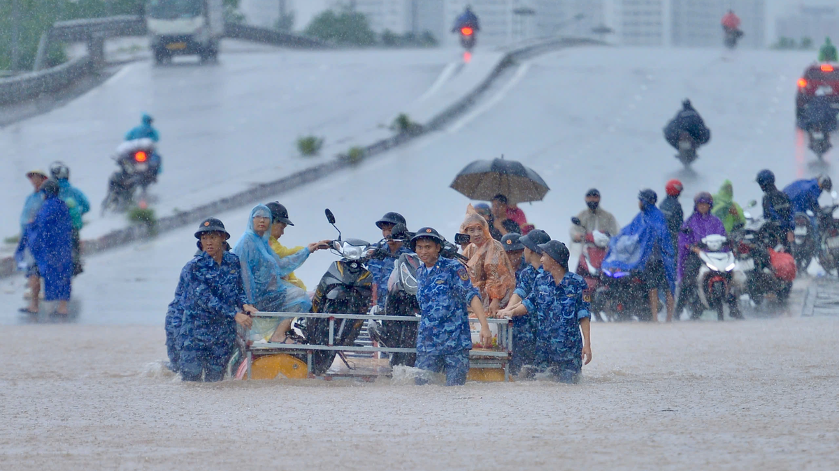
Just over a month later, storms No. 3 and No. 5 made landfall consecutively, causing winds of level 10-11, gusts of level 12, rain of 200-400 mm, in some places over 500 mm, causing floods exceeding level 3 on the Ca River, Ma River, Hoang Long River, Thao River systems...
Super typhoon No. 9 (super typhoon Ragasa) appeared in the East Sea in late September. For the first time in the history of forecasting, Vietnam determined that the storm's wind level reached level 17, gusting above level 17, the final level of the Bo-pho typhoon wind scale. This is the strongest super typhoon ever recorded in the East Sea. Although it weakened before reaching the shore, it showed the real risk of super typhoons in the context of climate change.
Notably, right after storm No. 9, storm No. 10 (storm Bualoi) made landfall directly in Ha Tinh and Northern Quang Tri with wind speeds of level 10-12, gusts of level 14, and widespread rain of 300-600 mm, causing widespread flooding, landslides, and flash floods from the North to the Central region. This is a storm with many unusual and extreme features.
There have been 14 widespread heavy rains across the country, including two unseasonal rains from the night of May 22 to 24 and from the night of June 10 to 13 in the Northern and Central Central regions.
Within just one month, storm No. 5 and storm No. 10 caused two serious and very serious natural disasters, fierce and occurring almost simultaneously...
Source: https://baotintuc.vn/van-de-quan-tam/canh-bao-cao-diem-mua-bao-va-kha-nang-ret-dam-tu-nua-cuoi-thang-12-20251007092353356.htm


![[Photo] Prime Minister Pham Minh Chinh chairs the 16th meeting of the National Steering Committee on combating illegal fishing.](https://vphoto.vietnam.vn/thumb/1200x675/vietnam/resource/IMAGE/2025/10/07/1759848378556_dsc-9253-jpg.webp)


![[Photo] Super harvest moon shines brightly on Mid-Autumn Festival night around the world](https://vphoto.vietnam.vn/thumb/1200x675/vietnam/resource/IMAGE/2025/10/07/1759816565798_1759814567021-jpg.webp)


Comment (0)