
According to the National Center for Hydro-Meteorological Forecasting, the risk of flash floods and landslides still occurs in the Northern provinces, Thanh Hoa and Nghe An. In particular, floods on Cau River and Thuong River ( Bac Ninh ) are particularly large and widespread flooding in Thai Nguyen province will continue for the next 3-4 days.
It is forecasted that the Northern provinces, Thanh Hoa and Nghe An will continue to have rain with common accumulated rainfall as follows: Phu Tho, Quang Ninh and Hai Phong from 20 - 50mm, some places over 90mm; Lai Chau, Tuyen Quang, Bac Ninh and Thanh Hoa from 20 - 40mm, some places over 80mm; other areas in the North from 5 - 15mm, some places over 40mm.
Recently, in the mountainous areas of the Northern provinces, there has been continuous heavy rain, the soil and rocks are saturated, floods on rivers are still at high levels (especially in Cao Bang, there has been an earthquake), so there is a high risk of landslides even when the rain has reduced or stopped.
Therefore, there is a risk of flash floods on small rivers and streams, landslides on steep slopes in many communes/wards of: Lai Chau, Phu Tho, Lao Cai, Tuyen Quang, Thai Nguyen, Cao Bang, Lang Son, Quang Ninh, Bac Ninh, Hai Phong, Thanh Hoa and Nghe An.
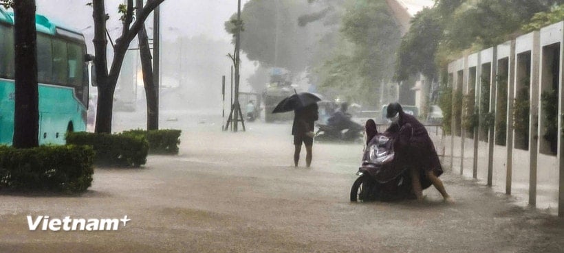
 are submerged in floodwater. (Photo: Quoc Dat/VNA)")
Warning level of natural disaster risk due to flash floods, landslides, land subsidence due to heavy rain or water flow: Level 1; Lang Son level 2; Thai Nguyen and Cao Bang level 3.
Flash floods and landslides can have very negative impacts on the environment, threaten people's lives; cause local traffic congestion, affect the movement of vehicles; destroy civil and economic works, causing damage to production and socio-economic activities.
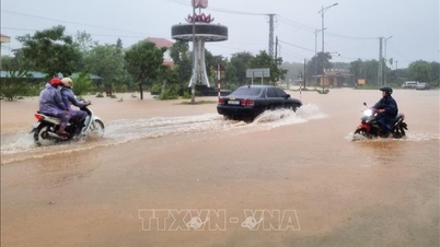
Exceptionally large floods on Cau River and Thuong River
Currently, floods on Cau River and Thuong River (Bac Ninh) continue to rise; floods on Luc Nam River (Bac Ninh) are slowly receding; water levels on other rivers in the North are rising.
Water levels at 1:00 a.m. on October 8 on rivers are as follows:
On Cau River at Gia Bay station, it is 29.9m, 1.09m above the historical level in 2024 (28.81m) (at 3:00 a.m. on October 8); at Dap Cau station, it is 6.05m, 0.25m below alarm level 3.
On Thuong River at Cau Son station 17m, above alarm level 3 is 1m; at Phu Lang Thuong station 6.97m, above alarm level 3 is 0.67m.
On Luc Nam River at Luc Nam station 5.3m, alarm 2.
On Thai Binh River at Pha Lai station 4.57m, below alarm level 2 is 0.43m.
It is forecasted that in the next 12 hours, flood on Cau River at Dap Cau station, on Thuong River at Phu Lang Thuong station will continue to rise above alert level 3, upstream Cau River (Thai Nguyen) at Gia Bay station will fluctuate at peak level, then decrease and be 0.19m above the historical flood in 2024; flood on Luc Nam River at Luc Nam station will continue to fall below alert level 2.
In the next 12-24 hours, flood on Cau River at Dap Cau station will continue to rise above alert level 3, at Gia Bay station it will continue to fall and be above alert level 3; flood on Thuong River at Phu Lang Thuong station will rise and exceed the historical flood level of 1986 (7.52m).
Flood on Luc Nam River at Luc Nam station continues to decrease and is at alert level 1- alert level 2.
")
Warning: From October 8-9, floods on rivers in the Northern region continue to rise. During this flood, the flood peak on Thai Binh River (Hai Phong) will rise to alert level 2; the flood peak on Thao River (Lao Cai), Lo River (Tuyen Quang), Hoang Long River (Ninh Binh) will rise to alert level 1-2, with some rivers above alert level 2.
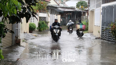
Widespread flooding in Thai Nguyen province will continue for the next 3-4 days, Bac Ninh, Lang Son, Cao Bang and risk of flooding in low-lying areas along rivers, urban areas in the Northern region; risk of landslides on river banks, river dykes, risk of flash floods on rivers and streams and landslides on slopes in mountainous areas of the Northern region. Warning level of natural disaster risk due to floods: Level 3.
Northeastern region
During the day, there will be scattered showers and thunderstorms, with some heavy rain in some places; at night there will be showers and thunderstorms in some places. Southeast wind level 2-3. During thunderstorms, there is a possibility of tornadoes, lightning and strong gusts of wind.
Lowest temperature from 22-25 degrees Celsius, mountainous areas have places below 21 degrees Celsius; highest from 28-31 degrees Celsius, some places above 31 degrees Celsius.
Hanoi capital
Cloudy, rain, moderate rain and thunderstorms in the morning, some places with heavy rain, then the rain decreases. Southeast wind level 2-3. During thunderstorms, there is a possibility of tornadoes, lightning and strong gusts of wind. Lowest temperature from 23-25 degrees Celsius, highest from 29-31 degrees Celsius.
Warning of thunderstorms, tornadoes, lightning, hail and local heavy rain in Hai Phong
Through monitoring weather radar images, it shows that convective clouds cause thunderstorms in villages/residential groups in the following communes/wards: Kinh Mon, Nguyen Dai Nang, Tran Lieu, Bac An Phu, Pham Su Manh, Nhi
Chieu, Nam An Phu, Thanh Ha, Ha Tay, Ha Bac, Ha Nam, Ha Dong, Hai Duong, Le Thanh Nghi, Viet Hoa, Thanh Dong, Nam Dong, Tan Hung, Thach Khoi, Tu Minh, Ai Quoc, Nam Sach, Thai Tan, Chu Van An, Chi Linh, Tran Hung Dao, Nguyen Trai, Tran Nhan Tong, Le Dai Hanh, Hop Tien, Tran Phu, An Phu, Thuy Nguyen, Thien Huong, Hoa Binh, Nam Trieu, Bach Dang, Luu Kiem, Le Ich Moc, Viet Khe, Hai An, Dong Hai, Hong Bang, Hong An, Ngo Quyen, Gia Vien, Le Chan, An Bien and coastal areas are continuing to develop.
During the period from 5am to 8am on October 8, the villages/residential groups in the above communes/wards and coastal areas will continue to have showers and thunderstorms.
During thunderstorms, be on guard against tornadoes, lightning and strong gusts of wind that can break trees, damage houses, traffic works and infrastructure, endangering human life and activities.
sea action
Source: https://baohaiphong.vn/lu-dac-biet-lon-tren-song-cau-song-thuong-522907.html


![[Photo] Parade to celebrate the 50th anniversary of Laos' National Day](/_next/image?url=https%3A%2F%2Fvphoto.vietnam.vn%2Fthumb%2F1200x675%2Fvietnam%2Fresource%2FIMAGE%2F2025%2F12%2F02%2F1764691918289_ndo_br_0-jpg.webp&w=3840&q=75)


![[Photo] Worshiping the Tuyet Son statue - a nearly 400-year-old treasure at Keo Pagoda](/_next/image?url=https%3A%2F%2Fvphoto.vietnam.vn%2Fthumb%2F1200x675%2Fvietnam%2Fresource%2FIMAGE%2F2025%2F12%2F02%2F1764679323086_ndo_br_tempimageomw0hi-4884-jpg.webp&w=3840&q=75)


Comment (0)