
The information was given by the Department of Hydrometeorology at an online meeting to discuss the rain and flood situation with the Central and Southern Hydrometeorological Stations and provincial/municipal hydrometeorological stations on the morning of November 18.
Heavy rain area moves down to Da Nang to Khanh Hoa
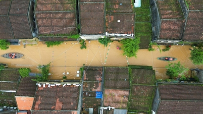
Analyzing the rain trend, Mr. Nguyen Van Huong, Head of Weather Forecast Department (National Center for Hydro-Meteorological Forecasting) said: From November 15 to today (November 18), the area from Ha Tinh to Khanh Hoa has experienced many heavy rains with common rainfall from 100-300mm.
Regarding local rain, there were a total of about 43 places with heavy rain over 500mm; 21 places with heavy rain over 600mm; 12 places with heavy rain over 700mm; 6 places with rain over 800mm; 3 places with rain over 900mm.
The rainiest spot was Binh Dien station ( Hue city), with total rainfall up to 1,108mm.

According to Mr. Huong, the heavy rain was mainly caused by cold air combined with strong easterly winds in the Central region. Photo: Trung Nguyen.
Currently, a cold air mass is strengthening from the north, combined with a strong easterly wind zone. It is forecasted that during the day and tonight (November 18), the area from Hue City, Da Nang City, Quang Ngai, the east of Dak Lak, Lam Dong and Khanh Hoa provinces will continue to have heavy to very heavy rain. The expected rainfall is 120-250mm, in some places over 400mm.
Southern Quang Tri province has rain from 70-150mm, locally over 250mm.
From Ha Tinh to northern Quang Tri, rain from 40-100mm, locally over 150mm.
From November 19, the rain area will narrow, mainly concentrated from the south of Hai Van Pass, from Da Nang City to the east of Quang Ngai, Dak Lak and Khanh Hoa provinces. Rain will gradually decrease with a common amount of 70-150 mm, but there is still a possibility of local rain spots over 250 mm. Heavy rain is expected to continue until about November 22.
Floods on many rivers rise back to alert level 3
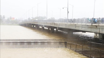
Regarding the flood situation, Mr. Phung Tien Dung, Head of Hydrological Forecasting Department, said: This morning, floods on rivers from southern Quang Tri to Dak Lak are fluctuating at high levels, from alert level 2 to above alert level 3. Rivers in Khanh Hoa and Quang Tri tend to go down to alert level 1.
Under the impact of heavy rain and cold air, it is forecasted that from November 18-20, floods on rivers from southern Quang Tri to Khanh Hoa, especially the area from Da Nang City to Gia Lai, will rise again.
Specifically, the flood peak on Thach Han River (Quang Tri) fluctuates at alert level 2-3; Bo River and Huong River (Hue City) are at alert level 2-3.
In Da Nang, flood on Vu Gia - Thu Bon river is likely to rise again to alert level 2-3 and above alert level 3.
In Quang Ngai, it is forecasted that tonight, Tra Khuc River, Ve River and Se San River will rise back to alert level 2-3 and above alert level 3.

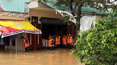
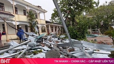
In less than a month, Hue City has experienced four consecutive floods. Photo: Van Dinh.
In Gia Lai, flood on An Lao and Lai Giang rivers rose above alert level 2; Kon River alone rose to alert level 2-3.
In Dak Lak, floods on Ba and Ky Lo rivers rose to alert levels 2-3 and above alert level 3; Srepok river rose above alert level 2.
In Khanh Hoa, Dinh Ninh Hoa River and Cai Nha Trang River rose back above alert level 2.
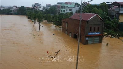
Heavy rain and floods will cause widespread flooding in low-lying areas along rivers, urban areas, and densely populated areas from Quang Tri to Khanh Hoa; flash floods and landslides in mountainous areas in provinces from Quang Tri to Lam Dong.
Heavy rain continues
Regarding the phenomenon of floods “decreasing and then increasing”, Mr. Huong said that the main reason is that the rain in the Central region follows the rhythm of the east wind. This is a typical weather pattern causing rain in this area. Each east wind will create a period of rain, followed by a new flood cycle. When the rain temporarily decreases, the flood subsides; when the rain increases again, the flood immediately rises again. People need to be extremely vigilant and proactively implement flood prevention solutions according to the recommendations of competent agencies and local authorities.
Rain is forecast to continue until around November 20, then gradually decrease and narrow the area concentrated along the coast. However, from November 23-24, the area from Da Nang to Khanh Hoa may continue to be affected by a new easterly wind, continuing to cause rain and possibly causing floods to rise again.
Regarding the risk of landslides, the Central region has experienced prolonged heavy rains over a wide area, especially the rains from October 25-30, from November 15-18 and the rains are expected to last for the coming days. Heavy rains from Ha Tinh to Lam Dong have put the mountainous areas in the west of these provinces at very high risk of flash floods and landslides.
“Even when the weather clears and the sun comes out, the ground is still saturated with water, so landslides and slides can continue to occur. This is something that people and local authorities need to pay special attention to in the coming time,” Mr. Huong emphasized.

Deputy Director of the Department of Hydrometeorology Hoang Duc Cuong. Photo: Khanh Ly.
According to Deputy Director of the Department of Hydrometeorology Hoang Duc Cuong: Before the dangerous natural disaster occurred, the Department of Hydrometeorology and stations had identified it early and sent information to the civil defense steering committee and disaster prevention agencies in the localities. In the current situation, heavy rains will increase and decrease alternately. Many reservoirs in this area are nearly full or full, so forecasting work needs to carefully calculate the flood discharge capacity of each reservoir to make an assessment of the water level on the rivers.
Units should strengthen monitoring of rain gauge systems and automatic meteorological stations, promptly detect and handle data errors; and at the same time develop backup plans to ensure information for continuous warning and forecasting.
On the other hand, due to the complicated developments of floods and the simultaneous occurrence of many types of natural disasters, local stations need to proactively raise the warning level of natural disaster risks, especially the risk of landslides and flash floods. The Deputy Director acknowledged the close coordination between provincial and regional stations, and at the same time requested that units continue to share information and propose issues that need support to improve the quality of forecasting and warning. From now until the end of the year is also the peak of the rainy season in the Central region, so we still need to be on guard against consecutive heavy rains in the coming time.
Source: https://nongnghiepmoitruong.vn/canh-bao-lu-giam-roi-se-dang-tro-lai-d784985.html

![[Photo] Prime Minister Pham Minh Chinh and his wife meet the Vietnamese community in Algeria](https://vphoto.vietnam.vn/thumb/1200x675/vietnam/resource/IMAGE/2025/11/19/1763510299099_1763510015166-jpg.webp)
![[Photo] General Secretary To Lam receives Slovakian Deputy Prime Minister and Minister of Defense Robert Kalinak](https://vphoto.vietnam.vn/thumb/1200x675/vietnam/resource/IMAGE/2025/11/18/1763467091441_a1-bnd-8261-6981-jpg.webp)


Comment (0)