
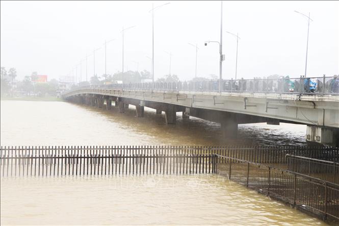
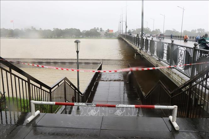
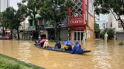
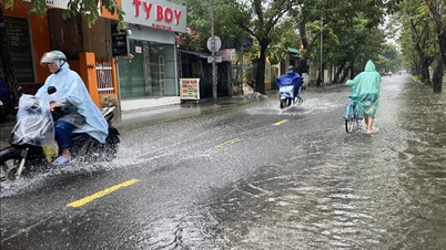
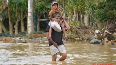
Forecasts indicate that due to the influence of the circulation of Typhoon No. 12 and a cold front combined with an easterly wind disturbance, from October 22nd to 24th, the city will experience heavy to very heavy rain; total rainfall will generally range from 250 to 500mm, with some areas exceeding 600mm. On the morning of the same day, flood levels on the Huong and Bo rivers exceeded alarm level 1. Warnings are issued that from October 23rd to 28th, the peak flood level on the Bo River at the Phu Oc station may exceed alarm level 3 by 0.3 to 0.5m; the Huong River at Kim Long may exceed alarm level 3 by 0.2 to 0.3m; there is a high risk of flooding in low-lying areas along the riverbanks and urban areas.
Areas at high risk of landslides due to heavy rain include: Nam Dong commune with 89 households in Lap and A Tin villages; Khe Tre commune with 90 households in Residential Group 1, Residential Group 2, Group 4, village 1 and Doi village hill, Pa Yem hill, and the embankment slopes of the La Son - Tuy Loan expressway. The two communes of Chan May - Lang Co and Phu Loc face a high risk of landslides along National Highway 49B, Bach Thach village, the Phuoc Tuong, Phu Gia, and Hai Van passes, the road to Bach Ma peak, the road to Laguna tourist area, the eastern slope of Chan May - Lang Co cape; and Trung Phuoc Tuong and Trung An villages. Phong Dien ward faces a high risk of landslides along Route 71 from Phong Xuan to the Rao Trang 3, Rao Trang 4, A Lin B2, and A Lin B1 hydroelectric reservoirs. In Binh Dien commune, there is a high risk of landslides along National Highway 49A. The communes from A Luoi 1 to A Luoi 5 need to be wary of landslides in mountainous areas and residential areas along the Ho Chi Minh Highway and National Highway 49A.
The current water levels in Huong Dien and Binh Dien reservoirs are capable of mitigating the peak flood level of a 400mm rainfall event, while Ta Trach reservoir is capable of mitigating the peak flood level of a 500mm rainfall event. Hue City's specialized agencies have developed a multi-reservoir operation scenario corresponding to rainfall amounts of 600-1000mm. The Hue City Military Command and Police Department maintain thousands of officers and soldiers and mobilize hundreds of vehicles and equipment ready to respond to storms and floods.
Local authorities in Hue City have reviewed and updated detailed relocation plans for over 10,000 households to respond to storms and rising water levels; focusing on coastal areas, lagoons, low-lying areas, and areas at risk of landslides. Hue City has also proactively stockpiled food, essential goods, and other necessities to ensure a response in the event of floods and storms.
Currently, due to the impact of strong winds, high waves, and high tides, seawater has flooded into Tam Giang Lagoon, causing localized flooding in Hai Duong and Phu Thuan areas of Thuan An ward; and the area along Tam Giang Lagoon and Con Toc ferry terminal in Dan Dien commune.
Source: https://baotintuc.vn/xa-hoi/hue-canh-bao-lu-cac-song-vuot-bao-dong-3-nguy-co-cao-sat-lo-dat-20251022110854611.htm
![[Photo] Closing Ceremony of the 10th Session of the 15th National Assembly](/_next/image?url=https%3A%2F%2Fvphoto.vietnam.vn%2Fthumb%2F1200x675%2Fvietnam%2Fresource%2FIMAGE%2F2025%2F12%2F11%2F1765448959967_image-1437-jpg.webp&w=3840&q=75)
![[Photo] Prime Minister Pham Minh Chinh holds a phone call with the CEO of Russia's Rosatom Corporation.](/_next/image?url=https%3A%2F%2Fvphoto.vietnam.vn%2Fthumb%2F1200x675%2Fvietnam%2Fresource%2FIMAGE%2F2025%2F12%2F11%2F1765464552365_dsc-5295-jpg.webp&w=3840&q=75)


![[OFFICIAL] MISA GROUP ANNOUNCES ITS PIONEERING BRAND POSITIONING IN BUILDING AGENTIC AI FOR BUSINESSES, HOUSEHOLDS, AND THE GOVERNMENT](https://vphoto.vietnam.vn/thumb/402x226/vietnam/resource/IMAGE/2025/12/11/1765444754256_agentic-ai_postfb-scaled.png)


Comment (0)