

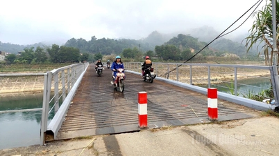
During this flood, peak water levels on the Kien Giang River, Thach Han River (Quang Tri), Bo River, Huong River (Hue City) and smaller rivers reached alarm level 2 - alarm level 3; the Gianh River (Quang Tri), Vu Gia - Thu Bon River ( Da Nang City), Tra Khuc River, Ve River (Quang Ngai) rose above alarm level 1 - alarm level 2, and in some places above alarm level 2.
There is a high risk of widespread flooding in the provinces from Quang Tri to Quang Ngai , and a high risk of flash floods on rivers and streams, and landslides on slopes in the provinces from Quang Tri to Quang Ngai (real-time warning information on flash flood and landslide risk areas is provided online on the website of the Department of Meteorology and Hydrology at: https://luquetsatlo.nchmf.gov.vn and in separate flash flood and landslide warning bulletins). Flood disaster risk level: level 2.
Currently, water levels on rivers from Quang Tri to Quang Ngai are fluctuating. At 7:00 AM on October 23rd, water levels on some rivers were as follows: On the Bo River at Phu Oc station, the water level was 2.13m, 0.63m above alarm level 1; on the Huong River at Kim Long station, the water level was 1.63m, 0.37m below alarm level 2; on the Kien Giang River at Le Thuy station, the water level was 1.72m, 0.48m below alarm level 2.
On the Mekong River, water levels in the upstream areas are changing slowly with the tide, showing a gradual downward trend. By October 27th, the highest daily water level on the Tien River at Tan Chau station was 3.45m, 0.05m below alarm level 1; on the Hau River at Chau Doc station it was 3.2m, 0.2m above alarm level 1; and at downstream stations of the Mekong River, water levels were at alarm level 1-2, with some areas exceeding alarm level 2.
There is a risk of flooding in low-lying areas, riverside areas, and areas outside dikes in An Giang province, as well as low-lying areas and riverside areas in Dong Thap, Can Tho, and Vinh Long provinces. Be prepared for potential erosion of dikes and embankments in flood-prone areas. Flood risk warning level 1.
Currently, water levels in the upstream areas of the Mekong River are changing slowly. The highest water levels on October 22nd were 3.62m on the Tien River at Tan Chau station, 0.12m above alarm level 1, and 3.37m on the Hau River at Chau Doc station, 0.13m below alarm level 2.
Flooding on rivers and streams can cause inundation in low-lying areas along the riverbanks, affecting activities such as waterway transportation, aquaculture, agricultural production, people's lives, and socio-economic activities.
Regarding rainfall, the National Center for Hydro-Meteorological Forecasting predicts that from the morning of October 23rd to the night of October 24th, the area from Ha Tinh to Quang Ngai will experience heavy rain and thunderstorms with rainfall amounts generally ranging from 100-200mm, and locally exceeding 300mm; specifically, the area from southern Quang Tri to Da Nang city will experience heavy to very heavy rain with rainfall amounts generally ranging from 200-350mm, and locally exceeding 700mm. A warning is issued regarding the risk of heavy rainfall exceeding 150mm/3h.
Additionally, on October 23rd, both day and night, the Lam Dong and Southern regions will experience scattered showers and thunderstorms with rainfall amounts of 15-30mm, with some areas receiving over 80mm of rain. During thunderstorms, there is a possibility of tornadoes, lightning, hail, and strong gusts of wind. A warning is issued regarding the risk of heavy rainfall exceeding 60mm/3h.
Over the next 48 to 72 hours, the area from Ha Tinh to Quang Ngai will experience moderate to heavy rain and thunderstorms, with some areas experiencing very heavy rain. Rainfall amounts will generally range from 40-80mm, with some areas exceeding 150mm. Heavy rain in this area is likely to continue until the end of October 2025.
Source: https://baotintuc.vn/van-de-quan-tam/canh-bao-lu-tren-cac-song-tu-quang-tri-den-quang-ngai-20251023100629423.htm

![[Photo] Prime Minister Pham Minh Chinh holds a phone call with the CEO of Russia's Rosatom Corporation.](/_next/image?url=https%3A%2F%2Fvphoto.vietnam.vn%2Fthumb%2F1200x675%2Fvietnam%2Fresource%2FIMAGE%2F2025%2F12%2F11%2F1765464552365_dsc-5295-jpg.webp&w=3840&q=75)


![[Photo] Closing Ceremony of the 10th Session of the 15th National Assembly](/_next/image?url=https%3A%2F%2Fvphoto.vietnam.vn%2Fthumb%2F1200x675%2Fvietnam%2Fresource%2FIMAGE%2F2025%2F12%2F11%2F1765448959967_image-1437-jpg.webp&w=3840&q=75)


![[OFFICIAL] MISA GROUP ANNOUNCES ITS PIONEERING BRAND POSITIONING IN BUILDING AGENTIC AI FOR BUSINESSES, HOUSEHOLDS, AND THE GOVERNMENT](https://vphoto.vietnam.vn/thumb/402x226/vietnam/resource/IMAGE/2025/12/11/1765444754256_agentic-ai_postfb-scaled.png)


Comment (0)