
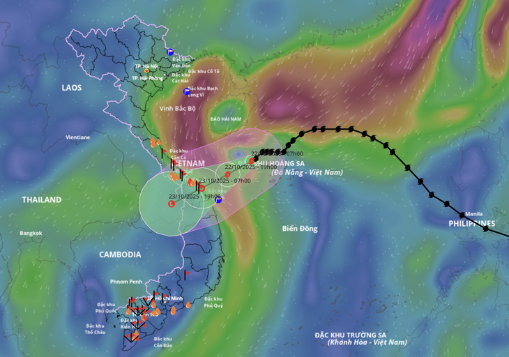
Forecast of the path of storm Than Gio - Photo: VNDMS
According to the meteorological agency, it is forecasted that this afternoon, October 22, storm Than Gio will move into the sea area from Hue City to Quang Ngai , and its intensity will continue to weaken to level 8.
Tonight to tomorrow morning the storm will weaken into a tropical depression, move inland from Hue city to Quang Ngai province, then continue to weaken.
Storm Than Wind is not strong but causes heavy rain
Due to the impact of cold air, the intensity of storm No. 12 (Wind God - Fengshen, the name given by China) is not too strong (maximum level 10), and cannot increase in intensity like storms No. 10 (Bualoi) and No. 11 (Matmo). When entering the Hoang Sa special zone, it is blocked by a cold air mass, so it changes direction and moves slowly.
Although the storm's intensity is not too strong, it is still forecast to cause heavy rain because the storm's circulation carries a large amount of moisture from the East Sea. In addition, when it makes landfall, it will combine with strong northeast winds and easterly wind disturbances.
The convergence of wind and humidity of the three above systems is stronger due to the wind-blocking effect of the Truong Son range in the Central region, causing the rain to intensify and last for many days, even after the storm dissipates.
Rain lasts for many periods
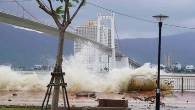
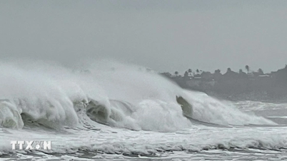
Due to the combination of the strengthening cold air, in the Gulf of Tonkin there are strong northeast winds of level 7, gusting to level 9. The sea area from Quang Tri to Quang Ngai (including Con Co special zone, Cu Lao Cham island and Ly Son special zone) has strong winds of level 6-7, the area near the storm's center has winds of level 8, gusting to level 10, waves 3-5m high, rough seas.
Coastal areas from Quang Tri to Da Nang have storm surges of 0.4-0.8m. There is a high risk of flooding in low-lying areas, coastal roads, and coastal erosion due to large waves combined with high tides and wind surges.
From this afternoon, on the mainland coastal provinces from Quang Tri to Da Nang City, winds will gradually increase to level 6-7, gusting to level 8-9. The strongest winds will be around tonight until the morning of October 23.
Heavy rain will be divided into many periods. The first period will be from the night of October 22 to 24. Due to the combined influence of storm No. 12 circulation and cold air along with the East wind, from Quang Tri to Da Nang, rainfall will be from 400-600mm, with some places having heavy rain over 800mm. Beware of rain intensity greater than 200mm/3 hours;
In Ha Tinh and Quang Ngai areas, rainfall ranges from 100-250mm, with some places over 400mm.
This rain season warns of the risk of flooding in urban and industrial areas due to heavy rain and rising sea levels causing slow drainage.
The second rain started on October 25 and lasted until October 27. The rain was caused by cold air combined with the East wind. Quang Tri and Hue had 200-300mm of rain, some places had over 500mm.
Ha Tinh, Da Nang City, Quang Ngai rain 100-200mm, some places over 300mm.
After October 27, rain is likely to continue in the Central region.
Detailed forecast of areas affected by storm Than Gio
Quang Tri: risk of strong storms in communes (16 communes/wards); risk of flash floods and landslides (41 communes/wards); risk of severe flooding (40 communes/wards).
Hue City is at risk of strong storms in communes (15 communes/wards); at risk of flash floods and landslides (14 communes/wards); at risk of severe flooding (nearly 30 communes/wards).
Da Nang City is at risk of strong storms in communes (22 wards/communes); Risk of flash floods and landslides (31 communes/wards); Risk of severe flooding (27 communes/wards).
Quang Ngai province is at risk of strong storms in communes (5 wards/communes); at risk of flash floods and landslides (31 communes/wards).
Source: https://tuoitre.vn/chieu-nay-bao-than-gio-vao-vung-bien-tp-hue-toi-quang-ngai-20251022113627905.htm


![[Photo] Da Nang: Shock forces protect people's lives and property from natural disasters](https://vphoto.vietnam.vn/thumb/1200x675/vietnam/resource/IMAGE/2025/10/22/1761145662726_ndo_tr_z7144555003331-7912dd3d47479764c3df11043a705f22-3095-jpg.webp)
![[Photo] Award Ceremony of the Political Contest on Protecting the Party's Ideological Foundation](https://vphoto.vietnam.vn/thumb/1200x675/vietnam/resource/IMAGE/2025/10/22/1761151665557_giaia-jpg.webp)
![[Photo] Prime Minister Pham Minh Chinh chairs meeting on nuclear power plant construction](https://vphoto.vietnam.vn/thumb/1200x675/vietnam/resource/IMAGE/2025/10/22/1761137852450_dsc-9299-jpg.webp)


Comment (0)