
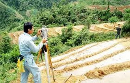
Currently, the rate of formal cadastral mapping in Lai Chau province has only been completed in some communes and towns of 4 out of 8 districts and cities, including Lai Chau City, Than Uyen, Phong Tho, and Sin Ho. Nam Nhun district has only had 5 out of 11 communes surveyed, and one commune in Than Uyen district, along with three districts (Tan Uyen, Tam Duong, and Muong Te) and some resettlement sites for hydropower projects, have yet to have formal cadastral mapping.
In a discussion with reporters on this issue, Mr. Ngo Xuan Hung, Deputy Director of the Department of Natural Resources and Environment, said: From 2018 to the present, Lai Chau province has spent nearly 65 billion VND to build land databases in 4 districts and cities. If we include the funding allocated by the province this year for building the land database in Tam Duong district, the total would reach 119 billion VND. This is a considerable amount for Lai Chau, but the province is making great efforts to build a land database to better serve land management. Because of the large budget for building the land database, Lai Chau strives to complete one district each year in a phased manner. After we build the database in Tam Duong, we will continue with Muong Te district, and then move on to the remaining communes of Nam Nhun district," Mr. Hung said.
It is known that on January 30, 2023, the People's Committee of Lai Chau province issued Decision No. 120/QD-UBND, approving the technical and cost estimates for cadastral surveying, land registration, issuance of land certificates, and preparation of cadastral records for 10 communes (excluding Na Tam, Ho Thau communes and Tam Duong town) and the construction of a land database for communes and towns in Tam Duong district.
Accordingly, Lai Chau province decided to assign the Department of Natural Resources and Environment as the investor to implement the cadastral surveying, land registration, issuance of land certificates, and creation of cadastral records for 10 communes in Tam Duong district, as well as to build a land database for the entire Tam Duong district, with a total estimated budget of over 54 billion VND. The three communes of Na Tam, Ho Thau, and Tam Duong town in Tam Duong district are responsible for providing additional funding for implementation.
Previously, the land databases of 4 districts and cities were surveyed and built, and are now operating and deployed stably at all three levels. The Land Registration Office monitors, updates, and adjusts land changes, and prints land certificates using the Vilis 2.0 software database.

Based on Lai Chau's land database development roadmap, the locality will soon have complete input data and information on land. If completed, this will help to improve the efficiency of the one-level registration office model. In this model, people can submit applications at any branch of the registration office, and processing officers can simply access the shared online system to retrieve cadastral information and process the applications.
For example, to obtain information about a plot of land in Nam Nhun district, simply filling in one of the following pieces of information: address, sheet number, plot number, coordinates, owner's name, or using the citizen identification code will provide complete information about the land plot, including its zoning plan, whether a land certificate has been issued, land type, price, number of previous transfers, whether there is a house on the land, and any disputes or complaints. This is one of the advantages of building a land database based on a data update system. Meeting these requirements is essential to ensuring compliance with the regulations for building a land database.
Source


Comment (0)