
 |
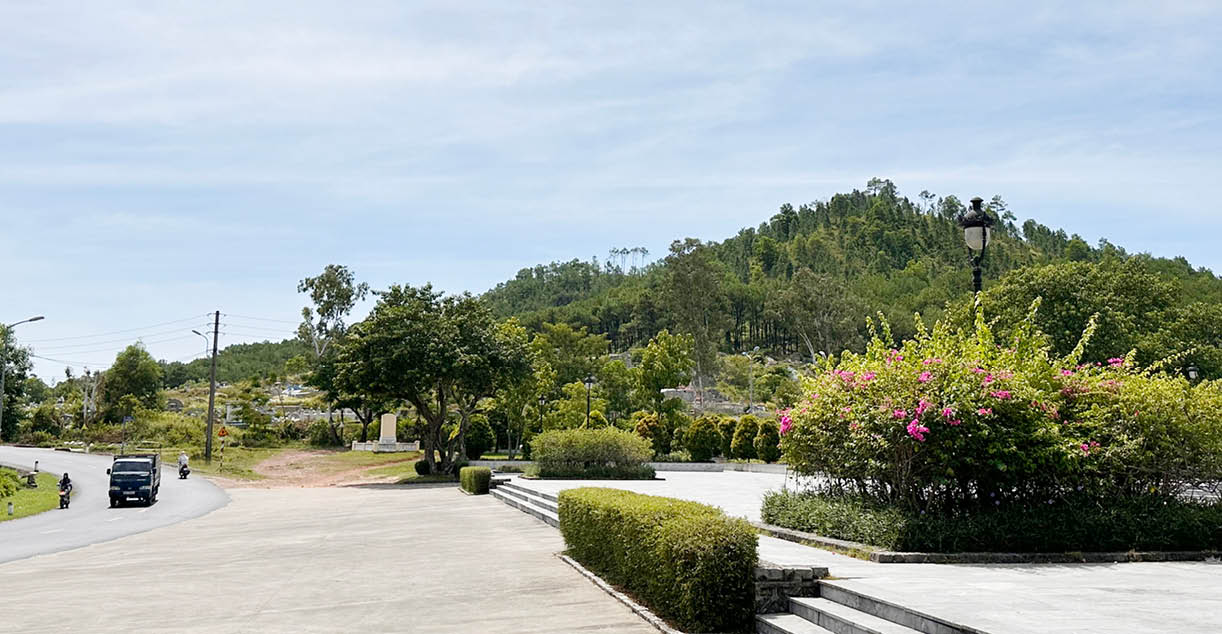
| Mount Ngự Bình as seen from the area around the statue of King Quang Trung. Photo: Bảo Phước |
This landmark is associated with the "front water, back mountain" geographical setting, where the Perfume River gathers the water and Ngu Mountain provides support. From the mountaintop, one can take in the entire city, the winding Perfume River, and the hidden pagodas and stupas, creating a unique and picturesque natural landscape of Hue .
However, the current state of the area shows that there are no walking trails or rest stops, and it has not been integrated into the official heritage tourism chain, while thousands of graves are concentrated at the foot of the mountain. Unfortunately, this is also an area where construction waste accumulates illegally, making both locals and tourists hesitant to approach.
In the city's development strategy, according to the "Building Thua Thien Hue into the land of golden apricot blossoms of Vietnam" project issued in 2021, the Ngu Binh and Ban mountain areas are one of six key areas for planting apricot blossom forests, with the goal of establishing native golden apricot blossom forests, organizing festivals, and developing a distinctive cultural and ecological tourism route.
Recently, in June 2025, the People's Committee of Hue City submitted for approval the investment plan for the Tran Phu - Ngu Binh road, with a total capital of nearly 177 billion VND. The road, 795m long and 19.5m wide, aims not only to reduce traffic pressure in the southern part of the city but also to serve as a dynamic infrastructure, creating a connection between the Ngu Binh mountain area and the Ring Roads II and III, linking to National Highway 1A and the expanded Truong An planning area. The project will relocate nearly 70 households, move graves, and improve the landscape – a necessary step to reshape the cultural and ecological axis at the southwestern gateway of Hue city.
Lessons from international models such as Table Mountain (South Africa), Bukit Timah (Singapore), or Olympus (Greece) show that height does not determine the value of a mountain, but rather how the city integrates that space into a point of contact between people, nature, and history. Ngu Binh Mountain has the potential to do just that if it is developed in the right direction.
First, at the foot of the mountain, the construction waste and surrounding cemetery need to be thoroughly addressed to create a memorial park combined with an ecological space. This could be a place for planting native yellow apricot blossoms, traditional bonsai... On the mountain slope, an ecological walking path should be designed using natural materials, with poetry boards, directional signs, and lighting. At the summit, a traditional wooden observation deck would serve as a place to admire the panoramic view of the ancient capital, and could also be used for small events, poetry readings, tea ceremonies, and performances of Hue's traditional court art, in keeping with the cultural atmosphere of Hue.
At the foot of the mountain, a cluster of "mountain villages" could be formed, connecting traditional craft villages, gardens, Hue folk singing experiences, calligraphy, and folk activities, creating livelihoods from culture. All of this needs to be placed within an integrated, sophisticated plan that does not encroach upon the pine forest and, most importantly, requires the participation and preservation of the local community, those who have lived at the foot of the mountain for generations.
Ngự Bình doesn't need grandiose projects or mass tourism; instead, it needs a landscape structure with cultural depth, gentle preservation, and social consensus, just as the city has preserved its heritage for generations. This is a pivotal moment as the city transitions to a higher level while facing development pressures. At this time, leveraging a symbol like Ngự Bình is not only about preservation but also about affirming its identity in the regional urban competition.
Source: https://huengaynay.vn/van-hoa-nghe-thuat/danh-thuc-nui-ngu-binh-156430.html

![[Photo] General Secretary and President To Lam presides over a meeting on assessing national development resources.](https://vphoto.vietnam.vn/thumb/1200x675/vietnam/resource/IMAGE/2026/05/20/1779253785852_a1-bnd-2943-8519-jpg.webp)
![[Photo] National Assembly Chairman Tran Thanh Man working with the Standing Committee of the Economic and Financial Committee](https://vphoto.vietnam.vn/thumb/1200x675/vietnam/resource/IMAGE/2026/05/20/1779249584387_ndo_br_1-jpg.webp)


![[Workers' Month 2026] Spreading love on the Vinh - Dong Hoi frontline: Nearly 1 billion VND spent on caring for the lives of workers.](https://vphoto.vietnam.vn/thumb/402x226/vietnam/resource/IMAGE/2026/05/20/1779237885217_img_8650.jpeg)


Comment (0)