
 |
| Dr. of Science and Architect Ngo Viet Nam Son |
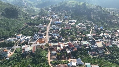
Ho Chi Minh City is truly becoming a coastal city.
After the merger, Ho Chi Minh City will expand into a megacity. How do you evaluate the opportunity for the City to reshape its planning with a century-long vision?
The merger with Binh Duong and Ba Ria - Vung Tau has opened up a completely new situation for Ho Chi Minh City, bringing unprecedented advantages.
First of all, Ho Chi Minh City has become a “super urban sub-region”. I use “sub-region” because in the Ho Chi Minh City metropolitan area there is a particularly important economic quadrilateral, including Ho Chi Minh City - Binh Duong - Dong Nai and Ba Ria - Vung Tau. These are four localities that have made great contributions to economic and budget growth and are where national infrastructure is concentrated, such as Long Thanh airport (Dong Nai), the largest railway station complex in Vietnam (old Binh Duong), Thi Vai - Cai Mep seaport complex, and the future international financial center in Ho Chi Minh City.
The merger will help triple the area of Ho Chi Minh City, while the population and GRDP will increase by about 1.5 times. For the first time, the city will have an unprecedentedly strong economic potential, if it knows how to plan a suitable development strategy, linked to regional connectivity.
In the competition with major urban areas in the world , such as Tokyo or Singapore, this merger opens up opportunities for the Southeast region, with Ho Chi Minh City as the leader, to rise to a competitive position in the future.
So, how will the urban economic spatial structure of Ho Chi Minh City be organized to maximize the advantages of each region, while avoiding duplication and competition?
Currently, the highest population density is in Ho Chi Minh City, developing in a centripetal pattern, while Binh Duong and Ba Ria - Vung Tau mainly develop along traffic axes. This is a favorable condition for reorganizing urban space after the merger.
Planning for the new Ho Chi Minh City is not simply a matter of combining three previous plans, but must also integrate three previous plans of three localities, and at the same time propose new strategic directions that were not possible before.
For example, for the first time, Ho Chi Minh City has truly become a coastal city.
With coastal urban areas stretching from Hiep Phuoc - Can Gio - Vung Tau - Long Hai to Ho Tram. Thi Vai - Cai Mep port cluster can be directly connected to Can Gio and to Ring Road 4, becoming a large-scale international seaport cluster, playing the role of an output for the entire industrial park of the region, including Binh Duong, Thu Duc, Dong Nai. This will be an important foundation for logistics development to help the economic growth of the region.
Binh Duong previously had advantages in attracting FDI and industrial development. Now that it is part of the new Ho Chi Minh City, the connection conditions will be better, creating a foundation for population dispersion and developing new urban areas of industry and high technology in highland areas, less affected by climate change and rising sea levels.
The future structure of Ho Chi Minh City's mega-city will follow a multi-center, multi-polar model. The multi-centers will be the inner city and the East, West, South, and North.
As for multi-pole, the center of Ho Chi Minh City will be the economic-financial nucleus, the center for training high-quality human resources, innovation and startups; the Binh Duong pole will aim for sustainable urban development, high-tech industrial urban areas; the Ba Ria - Vung Tau pole will develop international seaport urban areas, sea tourism and eco-tourism.
On that basis, the coastal area will form two large functional clusters. Firstly, the chain of seaport and industrial urban areas surrounding Ganh Rai Bay Can Gio, in which the Thi Vai - Cai Mep - Can Gio port cluster will have multimodal connections (waterway, railway, road and highway) with industrial parks and key urban areas to become a seaport cluster serving not only Ho Chi Minh City, but also a large urban area.
The second cluster is a chain of coastal tourism urban areas with diverse identities, from Can Gio eco-tourism urban area, coastal tourism urban area following the Dubai model, coastal tourism urban area Vung Tau - Ho Tram - Long Hai... attracting tourists, creating jobs and new urban space for residents.
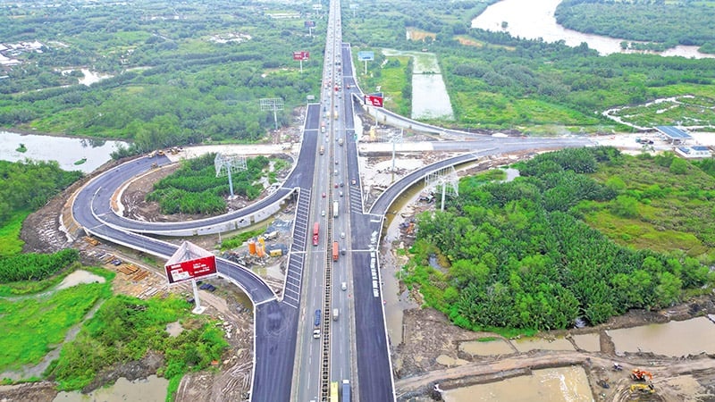 |
| Ho Chi Minh City has unprecedented economic potential to compete with major urban areas in the world. Photo: Le Toan |
Building strategic infrastructure for multipolar cities
When expanding development space, how should we prioritize the development of transport and logistics projects to create a backbone for inter-regional connectivity, sir?
Previously, the region's infrastructure was often stuck with three major bottlenecks: capital, regional connectivity, and multi-sector connectivity. These three bottlenecks now have a way out.
Regarding capital, we have had an orientation for urban development associated with transportation, especially the TOD model. This approach allows for the mobilization of social capital, while taking advantage of the added value of land funds around infrastructure routes to create a huge source of revenue for the budget, thereby reinvesting in infrastructure.
Regarding regional connectivity, Ho Chi Minh City previously encountered difficulties in cooperating with many localities, causing the coordination process to be prolonged. However, after the merger, coordination became much simpler.
The issue of multi-sectoral cooperation is also addressed. The merger of departments, such as Planning and Investment with Finance, and Planning - Architecture - Construction with Transport, can facilitate multi-sectoral cooperation to implement large projects under the new model, from TOD urban areas to seaport urban areas and airport urban areas.
Under such conditions, in the immediate future, infrastructure serving the multi-center, multi-polar model should focus on completing the beltway system and radial routes, and at the same time, it is necessary to form two strategic multi-modal infrastructure connection axes, including highways and metro with new urban areas on both sides, connecting Ho Chi Minh City's inner city with Binh Duong and Ba Ria - Vung Tau.
In the future, Can Gio will not only have a path from Nha Be, but also a connecting route from Beltway 4 extending from Ba Ria - Vung Tau. These will be key infrastructures, playing the role of backbone for the development of the super city of Ho Chi Minh City.
Flooding, climate change, traffic jams, lack of capital or development disparities between regions… In your opinion, what are the biggest challenges facing the planning and development of the new megacity of Ho Chi Minh City?
There are many challenges, but those challenges always come with opportunities.
For example, the inner city of Ho Chi Minh City has a very high construction density and dense concrete, leading to a serious lack of green space, as the inner city only has about 0.5 m2 of green space per person, while a good urban area needs at least 10 m2, meaning it needs to increase 20 times with limited land funds, while the housing demand is very large.
The second challenge is that Ho Chi Minh City has many low-lying areas that are at risk of flooding when sea levels rise. If population and infrastructure development in these areas continues, the future cost of response will be extremely expensive.
However, after the merger, the City has the opportunity to solve these problems by spreading the population to high ground, while at the same time linking it with industrial and service development in Binh Duong and Ba Ria - Vung Tau, thereby reducing the pressure on the inner city, creating conditions to increase green space.
The remaining issue is whether the City is determined to change towards a multi-sectoral mindset and a market economy mindset drastically or not?
In your opinion, what kind of regional governance model does Ho Chi Minh City need to ensure consistency in planning while promoting the strengths of each locality?
Entering the era of information technology and globalization, the management of a megacity like Ho Chi Minh City cannot follow the old way. If we know how to take advantage of smart technology and digital technology, management will be much simpler and more effective.
Previously, management followed a single-sector model, with each department holding its own piece of information, leading to a lack of coordination. Now it must be multi-sector, meaning that in every project, departments participate from the beginning. There will no longer be a situation where infrastructure is completed before urban spatial planning is considered. All data needs to be updated to a common digital system so that departments can exploit and coordinate together.
People should also benefit from smart governance. Instead of having to go to the center of Ho Chi Minh City to do procedures, people in Binh Duong or Ba Ria - Vung Tau can go to the public administration center branch near their residence to resolve the matter.
In other words, it is necessary to reorganize the urban area so that all residents in the city can have their needs for work, study, health care, entertainment, sports, administrative procedures, etc. met within a 15-minute radius from their place of residence. This requires the development of a multi-polar, multi-center urban model.
Source: https://baodautu.vn/dinh-hinh-sieu-do-thi-da-cuc-da-trung-tam-cho-tphcm-d374676.html


![[Video] Hue Monuments reopen to welcome visitors](https://vphoto.vietnam.vn/thumb/402x226/vietnam/resource/IMAGE/2025/11/05/1762301089171_dung01-05-43-09still013-jpg.webp)


![Dong Nai OCOP transition: [Part 2] Opening new distribution channel](https://vphoto.vietnam.vn/thumb/402x226/vietnam/resource/IMAGE/2025/11/09/1762655780766_4613-anh-1_20240803100041-nongnghiep-154608.jpeg)


Comment (0)