
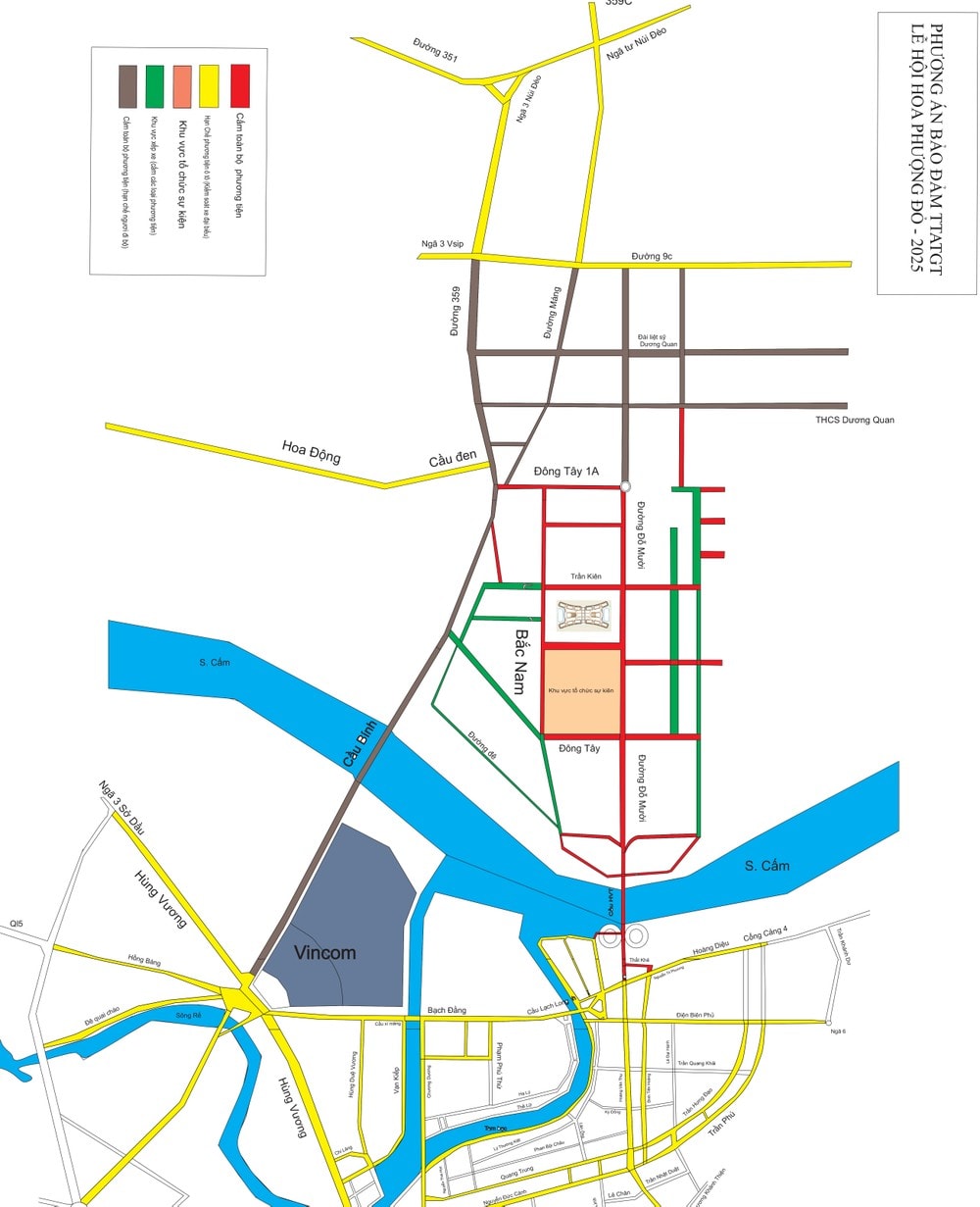
To ensure traffic safety and order during the 70th Anniversary of Hai Phong Liberation Day and the Opening Art Program of the Red Flamboyant Festival - Hai Phong 2025, Hai Phong City Police temporarily implemented traffic diversion on Tuesday, May 13.
According to the plan, from 2-11 p.m. on May 13, many roads in the central areas of Thuy Nguyen City and Hai Phong City will be closed to vehicles and pedestrians.
Roads that are closed to all vehicles and pedestrians include:
- That Khe Street;
- Hoang Van Thu Street and Hoang Van Thu Bridge;
- Do Muoi Street (from Hoang Van Thu - Nguyen Tri Phuong intersection to the intersection with East-West Highway 1A);
- East West Road;
- Tran Kien Street;
- North-South Road;
- East-West Road 1A;
- Branch roads adjacent to the Thuy Nguyen City Administrative Center area (where the event is held);
Roads banned from all vehicles:
- Binh Bridge Street (from the south intersection of Binh Bridge to Binh Bridge);
- Binh Bridge;
- Provincial Road 359 (from Binh Bridge to the intersection with Road 9C - VSIP Industrial Park);
- Mang Road - Thuy Nguyen City (section from the intersection with Provincial Road 359 to the intersection with Road 9C - VSIP Industrial Park);
- Adjacent branch routes directly connect to the above-mentioned road sections and routes.
Routes prohibited for trucks and buses:
Trucks and passenger cars are banned from National Highway 10 (from Quan Toan intersection to Da Bac bridge) during the ban period. Trucks and passenger cars are allowed to travel between Hai Phong and Quang Ninh , following the following route:
- Direction from Hai Phong to Quang Ninh:
+ Quy Cao intersection - provincial road 391 - provincial road 39B - national highway 5 - national highway 37 - national highway 18.
+ National Highway 10 - Hanoi - Hai Phong - Quang Ninh Expressway;
+ Quang Thanh Bridge - Provincial Road 390 - National Highway 37 - National Highway 18;
+ Dinh Bridge - Thanh Nien Street - Tran Hung Dao Street - National Highway 17B - National Highway 18;
+ Quan Toan 4-way intersection - National Highway 5 - Tien Trung 3-way intersection - National Highway 37 - National Highway 18.
- From Quang Ninh to Hai Phong: from National Highway 18, trucks and passenger cars are prohibited from traveling towards Da Bac Bridge and Ben Rung Bridge.
Restricted vehicle routes include inner city routes and adjacent routes leading to the Thuy Nguyen City Administrative Center area.
During the period of road closure and vehicle restrictions, people and tourists traveling from Hai Phong city center to Thuy Nguyen city and vice versa will pass through Kien bridge (National Highway 10).
Both sides of the Cam River: Traffic passing through Kien Bridge, National Highway 10.
PV (synthesis)Source: https://baohaiduong.vn/hai-phong-cam-mot-so-tuyen-duong-de-to-chuc-le-hoi-hoa-phuong-do-2025-411413.html


![[Photo] The Government Standing Committee works with ministries and branches on the real estate market situation.](https://vphoto.vietnam.vn/thumb/1200x675/vietnam/resource/IMAGE/2025/5/24/e9b5bc2313d14c9499b8c9b83226adba)

![[Photo] Ho Chi Minh City holds funeral for former President Tran Duc Luong](https://vphoto.vietnam.vn/thumb/1200x675/vietnam/resource/IMAGE/2025/5/24/9c1858ebd3d04170b6cef2e6bcb2019e)


![[Photo] Party and State leaders visit former President Tran Duc Luong](https://vphoto.vietnam.vn/thumb/1200x675/vietnam/resource/IMAGE/2025/5/24/960db9b19102400e8df68d5a6caadcf6)


Comment (0)