
.jpg)
Still divided
Consecutive heavy rains from late October to early November caused landslides and subsidence of the slope at many locations on DT601 route, through Hai Van ward.
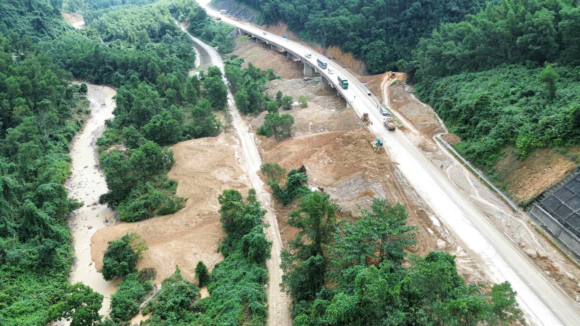
The Da Nang Infrastructure Maintenance Board (Department of Construction) said that the most serious landslide point is at km20+100, in Ta Lang residential group. At this location, the embankment and slope of La Son - Tuy Loan expressway (location km50+700 - km50+800) collapsed, the parallel DT601 roadbed underneath collapsed, leading to a road break. Barriers and warning signs were placed to prevent traffic to ensure safety.
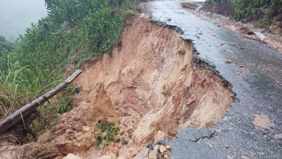
Extending westward, the DT601 route was cut off at several points along the route km30+150 - km30+650. The reason was that during the process of clearing landslides to serve the highway's opening, soil and rocks from the negative slope of the highway fell down, causing the DT601 road surface to be covered. The last section of the DT601 route, which has no residents, was also blocked because the roadbed at km33+900 collapsed and completely collapsed with a length of about 50m.
.jpg)
Mr. Le Van Minh Nga, Deputy Director of the Danang Infrastructure Maintenance Board, said that after the landslide occurred, the board directed and urged the unit managing the DT601 route, the Danang Bridge and Road Joint Stock Company, to urgently place warnings, barricades at dangerous locations and clear the landslide. Early last week, the unit basically completed the repair, ensuring the traffic flow from km20+400 to km30+150 under its management responsibility. The company is waiting for the expressway contractor to finish repairing the section from km30+150 to km30+650 before bringing in equipment to continue clearing to ensure traffic flow to km33+900.
Regarding the traffic jam at km20+100, the Danang Infrastructure Maintenance Board has proposed that the Department of Construction issue a document requesting the La Son - Tuy Loan Expressway Management Unit and the Ho Chi Minh Road Project Management Board to develop a plan to simultaneously handle the damage at the above location of the DT601 route during the process of implementing the repair of landslides on the expressway.
Currently, the contractor of the expressway has completed the work of clearing the negative slope of the highway that has overflowed and covered the road surface of DT601, section km30+150 - km30+650. However, the location at km30+400 has not been completed because this dumping has affected the forest land of Vinafor Da Nang Joint Stock Company.
Need long-term solutions
Mr. Dinh Van Hin, Head of Ta Lang residential group, said that the group has a hamlet of 7 households (30 people) on the side of DT601 route, above km20+100. In front of the hamlet is the negative slope of the highway, and Cu De river is behind. Due to the complicated developments of the flood near the end of October, the functional forces of Hai Van ward and the residential group mobilized and brought the hamlet of 7 households to take shelter in the houses of people located east of km20+100 of DT601 route.
.jpg)
Sitting at a relative's house, Ms. Dinh Thi Hang (family in hamlet 7) shared: "My family of 4 evacuated to live with my husband's parents for nearly a month now. Recently, the weather cleared up and we planned to go back to clean up the mud to stabilize our place, but the road was eroded and we could not go. My family's wish is for the State to relocate and resettle us in a safe place, so we will no longer be separated" - Ms. Hang said.
According to the owner of Hoan Hien grocery store (Ta Lang residential group), people who used to go to work in the fields or tourists who came to enjoy the scenery of the mountains and rivers stopped by the store quite a lot. Now, the road is blocked so there are no customers.
Mr. Dinh Van Hin said that the highway management unit has opened a temporary road for people to ride motorbikes onto the highway, go around the landslide site to go home or go to work. However, traveling on the highway with many cars passing by poses a potential safety risk. The authorities need to find a solution soon to clear the route.
In the long term, the city has a plan to relocate and arrange for 7 households to live in the Gian Bi resettlement area to stabilize their lives. "Otherwise, during the rainy season, people will have to pack up and evacuate because the area they are currently living in is not safe," Mr. Hin shared.
The representative of the Ho Chi Minh Road Project Management Board informed that the design consulting unit had drilled to check the geology of the landslide site between the DT601 route and the highway and found that the geology here is in a fractured area. Therefore, the plan to build an overpass at the km50+800 route (the highway route) was considered and the competent authority will be consulted for approval and construction to ensure the safety of the project. The unit also worked with Vinafor Da Nang Joint Stock Company to negotiate and resolve the location of the dumping of mud and soil that spilled onto the DT601 route.
DT601 route is more than 35km long, starting at the intersection with DT602 route in front of the old Hoa Son commune headquarters (Hoa Khanh ward) through the old Hoa Lien and Hoa Bac communes (Hai Van ward) to the border of Hue city. The route will be upgraded, expanded and put into use in early 2024.
Source: https://baodanang.vn/khac-phuc-sat-lo-tren-tuyen-dt601-can-giai-phap-lau-dai-3311419.html


![[Photo] VinUni students' emotions are sublimated with "Homeland in the Heart: The Concert Film"](/_next/image?url=https%3A%2F%2Fvphoto.vietnam.vn%2Fthumb%2F1200x675%2Fvietnam%2Fresource%2FIMAGE%2F2025%2F11%2F26%2F1764174931822_10-3878-jpg.webp&w=3840&q=75)


Comment (0)