
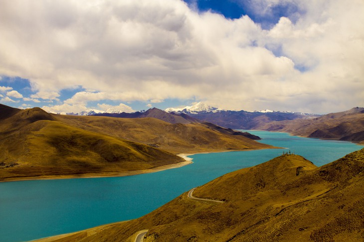
A lake in Tibet - Photo: WINDHORSE
Satellite imagery over decades shows that lakes in Tibet, known as the “roof of the world ,” are rising rapidly. This growth is changing the terrain, with potential impacts on ecosystems, infrastructure, and human life.
Where lake area increases fastest in the world
An increase in the number and area of lakes has been recorded in Nyima and Qiemo counties, Changtang region, Tibet.
The Thematic Mapper (TM) on Landsat 5 captured an image on August 1, 1994, while the Operational Land Imager-2 (OLI-2) on Landsat 9 captured another image on August 11, 2024.
A comparison between the two photos shows the significant expansion of lakes in the area.
Since the 1970s, the Landsat satellite has provided regular imagery of the Tibetan Plateau, providing scientists with a long-term dataset for study.
A global study based on Landsat data, published in the journal Science , has identified the northern Tibetan Plateau as having the fastest rate of lake area increase in the world between 1992 and 2020.
In another study published in 2024, scientists estimated that in 1991, the Tibetan Plateau had a total of 4,385 lakes with an area larger than 0.1 km², with 4.2% of them having an area of 10-50 km² and 2.9% having an area larger than 50 km².
The total area of the lakes on the plateau was then 37,471 km², larger than the area of Lake Erie. By 2023, the number of lakes had increased to more than 6,159, with a total area of 53,267 km² - nearly the area of Lake Michigan.
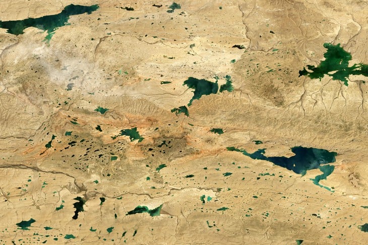
Lakes in Tibet rapidly expanding in area - Photo: SCITECHDAILY
Why is the lake expanding?
Most lakes on the Tibetan Plateau are located in endorheic basins, meaning that water flows in but has no natural outlet. Therefore, the lake area is governed by rainfall, evaporation rates, seasonal melt, and glacier melt.
Multiple studies published in scientific journals such as Scientific Reports, Journal of Hydrology and Science of the Total Environment have analyzed decades of Landsat satellite imagery and confirmed the significant expansion of lakes in the northern Tibetan Plateau.
Some research groups have suggested that increased rainfall is the main cause of the lakes' expansion, while other studies have highlighted that rising air temperatures, which lead to melting permafrost and glaciers, also play a major role in the process.
Scientists have also warned of the long-term impacts of this situation. A study published in the journal Nature Geoscience predicts that by 2100, the expansion of the lake could cause "widespread ecological and social impacts".
Hundreds of kilometres of roads, hundreds of residential areas and some 10,000 square kilometres of grassland, farmland and wetlands are at risk of being submerged.
"The rapidly expanding lake area is submerging homes, forcing people to relocate livestock, and making some glacier lakes more susceptible to sudden ruptures, causing flash floods," said Fangfang Yao, a researcher at the University of Colorado Boulder and lead author of the study published in the journal Science .
“The Tibetan Plateau is a harsh and remote environment. Satellites like Landsat are the only tools we have to observe changes in lakes over long periods of time,” he added.
With an average altitude of over 4,500m above sea level, Tibet has a harsh climate, with little rainfall and often low temperatures. This makes some areas arid, with poor soil and sparse vegetation, similar to cold deserts around the world.
![[Photo] Prime Minister Pham Minh Chinh holds meeting to launch exhibition of national achievements to celebrate 80th National Day](https://vphoto.vietnam.vn/thumb/1200x675/vietnam/resource/IMAGE/2025/6/23/0c0c37481bc64a9ab31b887dcff81e40)


![[Photo] Prime Minister Pham Minh Chinh chairs the national online conference on combating smuggling, production and trade of counterfeit goods.](https://vphoto.vietnam.vn/thumb/1200x675/vietnam/resource/IMAGE/2025/6/23/4a682a11bb5c47d5ba84d8c5037df029)


![[INFOGRAPHIC] Delacour's langur "revives" in Trang An](https://vphoto.vietnam.vn/thumb/402x226/vietnam/resource/IMAGE/2025/6/23/7ce6071e3a134f0c92ed4f2d591436e7)


![[Photo] Conference to disseminate the implementation of the Plan to promote digital transformation to meet the requirements of restructuring the political system's apparatus](https://vphoto.vietnam.vn/thumb/1200x675/vietnam/resource/IMAGE/2025/6/23/4744403cccd144b79086799e2ceb686e)
![[Photo] Party Congress of the Central Internal Affairs Commission for the 2025-2030 term](https://vphoto.vietnam.vn/thumb/1200x675/vietnam/resource/IMAGE/2025/6/23/5bf03821e6dd461d9ba2fd0c9a08037b)


Comment (0)