
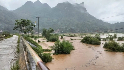
Currently, floods on Cau River, Thuong River, Luc Nam River ( Bac Ninh ) are rising rapidly; water levels on other rivers in the North and Thanh Hoa are rising.
Water levels at 2:00 p.m. on October 7 on rivers are as follows:
On Cau River at Gia Bay station 28.87m, 0.06m above the historical level in 2024 (28.81m); at Dap Cau station 5.24m, 0.06m below alarm level 2;
On Thuong River at Cau Son station 16.40m, above alarm level 3 0.4m; at Phu Lang Thuong station 5.95m, below alarm level 3 0.35m;
On Luc Nam River at Luc Nam station 5.29m, at alarm level 2.
On Thai Binh River (Hai Phong) at Pha Lai station 4.10m (at 1:00 p.m. on October 7), 0.10m above alarm level 1.
It is forecasted that in the next 12 hours, flood on Cau River at Dap Cau station, Thuong River at Phu Lang Thuong station will continue to rise above alert level 3; flood on Luc Nam River at Luc Nam station will continue to rise to alert level 2-3.
In the next 12-24 hours, floods on Cau River at Dap Cau station and Thuong River at Phu Lang Thuong station will continue to rise and be above alert level 3, about 0.2-0.4m lower than historical floods.
Floods on the Luc Nam River at Luc Nam station are likely to change slowly at peak level between alert level 2 and alert level 3 on the night of October 7, then slowly decrease.
The meteorological agency said that from this afternoon (October 7) to October 9, floods on rivers in the Northern region and Thanh Hoa continued to rise. During this flood, the flood peak on Thai Binh River ( Hai Phong ) reached alert level 2-alarm level 3; the flood peak on Thao River (Lao Cai), Lo River (Tuyen Quang), Hoang Long River (Ninh Binh), and the upper Ma River (Thanh Hoa) reached alert level 1-alarm level 2, with some rivers above alert level 2.
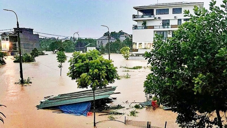
Rising floodwaters cause widespread flooding in the provinces of Thai Nguyen, Bac Ninh, Lang Son, Cao Bang and risk of flooding in low-lying areas along rivers and urban areas in the Northern region and Thanh Hoa; risk of landslides on river banks and river dykes, risk of flash floods on rivers and streams and landslides on steep slopes in the mountainous areas of the Northern region and Thanh Hoa.
Details of communes/wards at risk of flooding:
Thai Nguyen: Phan Dinh Phung Ward, Linh Son Ward, Tich Luong Ward, Gia Sang Ward, Quyet Thang Ward, Quan Trieu Ward, Pho Yen Ward, Song Cong Ward, Ba Xuyen Ward, Phu Binh Commune, Diem Thuy Commune, Kha Son Commune, Tan Khanh Commune, Dong Hy Commune, Van Lang Commune, Bach Quang Ward, Van Xuan Ward, Trung Thanh Ward, Cho Don Commune, Thanh Thinh Commune, Cho Moi Commune.
Bac Ninh: Hop Thinh, Xuan Cam, Tam Giang, Yen Trung, Nenh ward, Yen Dung, Canh Thuy, Kep commune, Tien Luc, Nha Nam, Yen The, Tien Phong ward, Phuong Son ward, Chu ward, Tuan Dao, An Lac, Duong Huu, Dai Son, Bien Son, Bien Dong, Luc Ngan, Deo Gia, Truong Son, Luc Son, Luc Nam, Nghia Phuong, Cam Ly, Tan An, Phat Tich commune, Tri Qua ward, Thuan Thanh ward, Mao Dien ward, Chi Lang commune, Bong Lai ward, Dao Vien ward, Dai Lai, Nhan Thang, Cao Duc.
Lang Son: That Khe, Trang Dinh, Khang Chien, Quoc Viet, Yen Binh, Van Nham, Huu Lung.
Cao Bang: Bao Lac, Bao Lam, Quang Lam, Ly Bon, Nam Quang, Thuc Phan, Nung Chi Cao, Tan Giang.
Flood disaster risk warning level: Level 3.
Source: https://nhandan.vn/nuoc-song-cau-len-nhanh-vuot-muc-lich-su-gay-ngap-lut-dien-rong-post913551.html

![[Photo] Prime Minister Pham Minh Chinh inspects and directs the work of overcoming the consequences of floods after the storm in Thai Nguyen](https://vphoto.vietnam.vn/thumb/1200x675/vietnam/resource/IMAGE/2025/10/08/1759930075451_dsc-9441-jpg.webp)


![[Photo] Prime Minister Pham Minh Chinh attends the World Congress of the International Federation of Freight Forwarders and Transport Associations - FIATA](https://vphoto.vietnam.vn/thumb/1200x675/vietnam/resource/IMAGE/2025/10/08/1759936077106_dsc-0434-jpg.webp)


![[Video] Proposal to increase special allowances for civil servants and health officials](https://vphoto.vietnam.vn/thumb/402x226/vietnam/resource/IMAGE/2025/10/09/1759968189853_720-jpg.webp)


Comment (0)