
 |
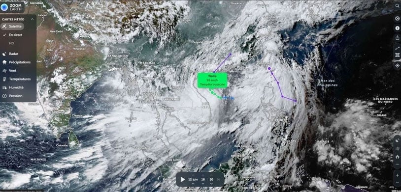
| The movement of storm No. 1 via satellite. (Photo: VNA) |
According to the National Center for Hydro-Meteorological Forecasting, from June 13-16, many dangerous weather patterns will continue to occur such as storm No. 1, heavy rain, flash floods, landslides...
The storm keeps changing direction.
According to the National Center for Hydro-Meteorological Forecasting, at 4:00 a.m. on June 13, the eye of the storm was located at approximately 17.9 degrees North latitude; 108.9 degrees East longitude, in the sea south of Hainan Island (China). The strongest wind near the eye of the storm was level 10 (89-102 km/h), gusting to level 13; moving northwest at a speed of approximately 10 km/h.
Commenting specifically on the developments, Associate Professor, Doctor, Director of the National Center for Hydro-Meteorological Forecasting Mai Van Khiem said that by 4:00 a.m. on June 14, the storm was moving in a North-Northwest direction after turning North-Northeast over the eastern sea area of the Northern Gulf of Tonkin at a speed of about 10km/h.
The danger zone is the northwest of the North East Sea, the offshore waters from Quang Tri to Quang Nam , and the waters of the Gulf of Tonkin. Disaster risk warning level 3.
At 4:00 a.m. on June 15, the storm moved in a north-northeast direction over the southwestern area of Guangdong province (China) at a speed of about 15km/h. The storm's strongest wind was level 7, gusting to level 9, and then gradually weakened into a tropical depression. The dangerous area was the northwest of the North East Sea, the sea area north of the Gulf of Tonkin. Disaster risk warning level 3.
At 4:00 a.m. on June 16, the tropical depression moved northeastward over southern China at a speed of about 20-25 km/h and gradually weakened into a low pressure area. Wind force below level 6.
Due to the impact of the storm, the Northwest of the North East Sea, the offshore sea from Quang Tri to Quang Nam has strong winds of level 6-8, near the eye of the storm level 9-10, gusts of level 13, waves 3-5m high; near the eye of the storm 4-6m, very rough seas. The sea in the Gulf of Tonkin has strong winds of level 6-7, near the eye of the storm level 8-10, gusts of level 13, waves 2-4m high, especially in the East 3-5m, very rough seas.
Ships operating in the above mentioned dangerous areas are likely to be affected by storms, whirlwinds, strong winds and large waves.
For coastal areas, due to the influence of high tides and storm surges, provinces from Hai Phong to Nghe An are likely to experience high sea levels (Hon Dau 3.9m, Hon Ngu 2.8m) causing localized flooding in some low-lying coastal and river mouth areas between 5-7pm on June 13 and 14.
Heavy rain in Central and Kon Tum
According to the National Center for Hydro-Meteorological Forecasting, early morning and June 13, the area from Quang Binh to Hue will have heavy to very heavy rain with common rainfall of 50-130mm, some places over 250mm; the area of Southern Nghe An, Ha Tinh, from Da Nang to Quang Ngai and Kon Tum will have moderate rain, heavy rain, locally very heavy rain and thunderstorms with common rainfall of 20-50mm, some places over 120mm.
Warning of risk of localized heavy rain over 120mm in 6 hours
In addition, on June 13, in the Northeast region, Thanh Hoa, Northern Nghe An and Quang Ngai, there will be heavy rain with rainfall of over 50mm in some places.
From the night of June 13, heavy rain in the above areas will decrease. During thunderstorms, there is a possibility of tornadoes, lightning and strong gusts of wind.
Disaster risk level due to heavy rain: level 1, level 2 in Quang Tri and Hue areas.
Heavy rains are likely to cause flooding in low-lying areas, urban and industrial areas; flash floods on small rivers and streams, landslides on steep slopes (real-time warning information on areas at risk of flash floods and landslides is provided online on the website of the Department of Hydrometeorology at: https://luquetsatlo.nchmf.gov.vn and in separate bulletins warning of flash floods and landslides).
On the night of June 12, the area from Nghe An to Quang Nam had moderate to heavy rain, while the area from Quang Binh to Da Nang had heavy to very heavy rain. The rainfall from 7:00 p.m. on June 12 to 3:00 a.m. on June 13 was over 170mm in some places, such as: Hai Lam (Quang Tri) 175.2mm, Hong Van (Hue) 173.8mm, Phuc Trach (Quang Binh) 172.2mm.
Risk of flash floods and landslides in 8 provinces and cities
According to the National Center for Hydro-Meteorological Forecasting, from 4:40 a.m. to 10:40 a.m. on June 13, the areas from Ha Tinh to Hue city will continue to have rain with accumulated rainfall ranging from 40-80mm, in some places over 120mm; from Da Nang to Quang Ngai and Kon Tum, it will range from 10-30mm, in some places over 50mm.
High/very high risk of flash floods on small rivers and streams, landslides on steep slopes in the above provinces and cities, especially in the districts: Cam Xuyen, Duc Tho, Huong Khe, Huong Son, Ky Anh, Nghi Xuan, Thach Ha, Hong Linh town, Ky Anh town, Vu Quang (Ha Tinh province); Bo Trach, Le Thuy, Minh Hoa, Quang Ninh, Quang Trach, Dong Hoi city, Tuyen Hoa, Ba Don town (Quang Binh province); Cam Lo, Dakrong, Gio Linh, Hai Lang, Huong Hoa, Trieu Phong, Quang Tri town, Vinh Linh (Quang Tri province);
A Luoi, Phu Loc, Phu Xuan, Thuan Hoa, Huong Thuy town, Huong Tra town, Phong Dien town (Hue city); Hoa Vang, Cam Le, Lien Chieu, Son Tra (Da Nang city); Bac Tra My, Dai Loc, Dong Giang, Duy Xuyen, Hiep Duc, Nam Giang, Nam Tra My, Nui Thanh, Phu Ninh, Phuoc Son, Que Son, Tay Giang, Thang Binh, Tien Phuoc (Quang Nam province); Ba To, Binh Son, Son Ha, Son Tay, Son Tinh, Tra Bong (Quang Ngai province); Dak Glei, Dak To, Kon Plong, Ngoc Hoi, Tu Mo Rong (Kon Tum province).
Warning level of natural disaster risk due to flash floods, landslides, land subsidence due to heavy rain or water flow level 1, Quang Tri province, Hue city, Da Nang city and Quang Nam level 2.
From 2:00 a.m. on June 12 to 2:00 a.m. on June 13, in the provinces from Ha Tinh to Quang Ngai and Kon Tum province, there was heavy to very heavy rain such as: Ky Thinh (Ha Tinh) 215.2mm; Vuc Tron Lake (Quang Binh) 339.8mm; La To Hydropower Dam (Quang Tri) 568mm; Bach Ma (Hue City) 669.2mm; Trung Tam GD-DN05-06 (Da Nang City) 424.8mm; Dai Son (Quang Nam) 332.2mm; Tra Thanh (Quang Ngai) 130.2mm; Dak Ro Ong (Kon Tum) 187.6mm;...
Soil moisture models show that some areas in the above provinces are close to saturation (over 85%) or have reached saturation.
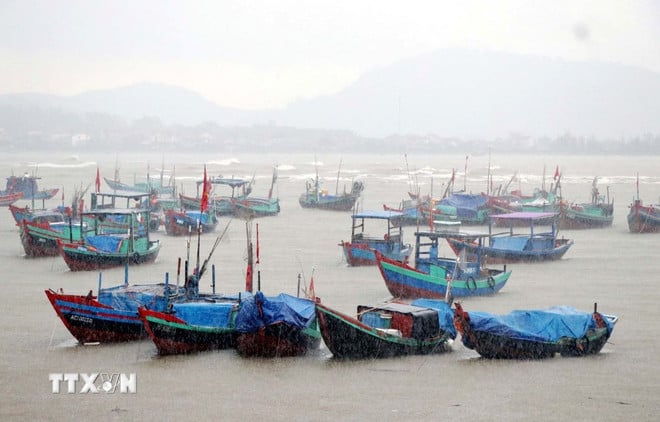 |
| Boats take shelter from the storm in Cam Nhuong commune, Cam Xuyen district. (Photo: Cong Tuong/VNA) |
Weather in regions day and night June 13:
- Northwest: Scattered showers and thunderstorms in some places, with the possibility of tornadoes, lightning and strong gusts of wind during thunderstorms. Lowest temperature 23-26 degrees Celsius, some places below 22 degrees Celsius. Highest temperature 31-34 degrees Celsius, some places above 34 degrees Celsius.
- Northeast: Scattered showers and thunderstorms, with the possibility of tornadoes, lightning and strong gusts of wind during thunderstorms. North to Northwest wind level 2-3, coastal areas level 3-4. Lowest temperature 24-27 degrees Celsius, mountainous areas below 22 degrees Celsius. Highest temperature 31-34 degrees Celsius.
- Hanoi: Scattered showers and thunderstorms, with the possibility of tornadoes, lightning and strong gusts of wind. North to Northwest winds at level 2-3. Lowest temperature 25-27 degrees Celsius. Highest temperature 32-34 degrees Celsius.
- Provinces and cities from Thanh Hoa to Hue: In the North, there will be moderate to heavy rain during the day, with some very heavy rain in some places, and scattered showers and thunderstorms at night; in the South, there will be heavy to very heavy rain and thunderstorms during the day, and scattered showers and thunderstorms at night. During thunderstorms, there is a possibility of tornadoes, lightning, and strong gusts of wind. Northwest to West wind level 2-3, especially in the South level 3-4. Lowest temperature 24-27 degrees Celsius. Highest temperature in the North 31-33 degrees Celsius, in the South 27-29 degrees Celsius.
- Provinces and cities from Da Nang to Binh Thuan: In the North, there will be moderate to heavy rain, locally very heavy rain and thunderstorms, scattered showers and thunderstorms at night; in the South, there will be showers and thunderstorms in some places, with the possibility of tornadoes, lightning and strong gusts of wind during thunderstorms. West to Southwest wind level 3-4. Lowest temperature 25-28 degrees Celsius. Highest temperature in the North 28-30 degrees Celsius, in the South 32-34 degrees Celsius.
- Central Highlands: There are showers and thunderstorms in some places, scattered showers and thunderstorms in the late afternoon and evening; Kon Tum has moderate rain, heavy rain, locally very heavy rain, in thunderstorms there is a possibility of tornadoes, lightning and strong gusts of wind. Southwest wind level 3. Lowest temperature 20-23 degrees Celsius. Highest temperature 26-29 degrees Celsius
- Southern region: There will be scattered showers and thunderstorms in some places; in the late afternoon and evening there will be scattered showers and thunderstorms, with the possibility of tornadoes, lightning and strong gusts of wind during thunderstorms. Southwest wind level 3. Lowest temperature 24-27 degrees Celsius. Highest temperature 29-32 degrees Celsius.
According to Vietnamplus
Source: https://baodanang.vn/xa-hoi/202506/thoi-tiet-ngay-13-6-bao-lien-tuc-doi-huong-vung-gan-tam-giat-cap-13-4008625/


![[Photo] Prime Minister Pham Minh Chinh receives leaders of several Swedish corporations](https://vphoto.vietnam.vn/thumb/1200x675/vietnam/resource/IMAGE/2025/6/14/4437981cf1264434a949b4772f9432b6)


Comment (0)