
At 1:00 a.m. on June 25, the center of the tropical depression was located at about 16.7 degrees North latitude; 115.6 degrees East longitude, about 440 km east of the Hoang Sa sea area. The strongest wind near the center reached level 6 (39-49 km/h), gusting to level 8. The system is moving northwest at a speed of about 15 km/h.
It is forecasted that in the next 24 hours, the tropical depression will strengthen, with winds near the center reaching level 6-7, gusting to level 9. At 1:00 a.m. on June 26, the center of the tropical depression was about 260km north of Hoang Sa. The dangerous area in the East Sea with strong winds from level 6 or higher, gusting to level 8, is determined from latitude 15.5 to 19.5 degrees North and from longitude 111.5 to 116.5 degrees East. The level of natural disaster risk due to strong winds at sea is warned at level 3.
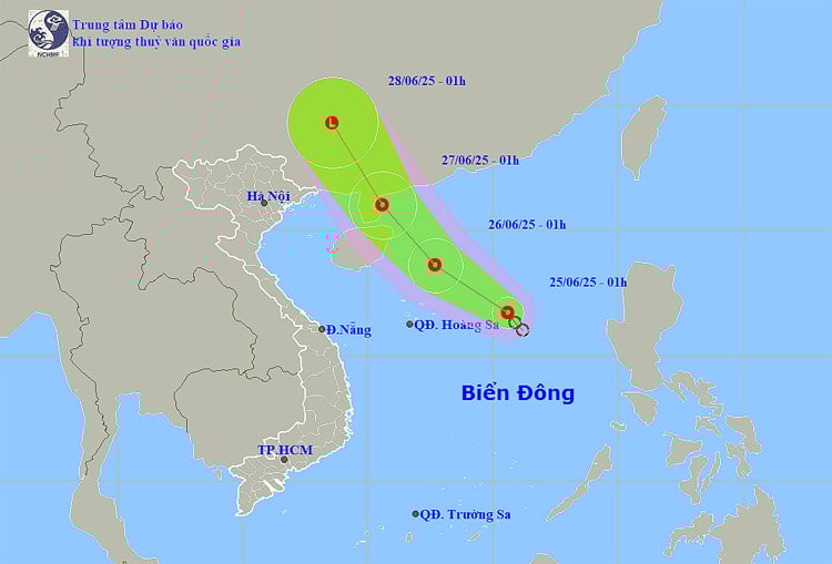
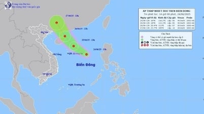
Path and location of tropical depression on June 26.
In the next 48 hours, the low pressure will continue to move northwest, approaching the Leizhou Peninsula (China), maintaining intensity at level 6-7, gusting to level 9. The dangerous area will expand to the north, from latitude 17.5 degrees and above.
In the North East Sea, including the Hoang Sa sea area, there are currently thunderstorms with strong winds of level 6-7, gusting to level 9. Waves are commonly 2.0 to 4.0m high, with rough seas. Vessels operating in this area should pay special attention to the risk of tornadoes and big waves.
In the central and southern East Sea (including Truong Sa sea area), as well as the sea area from Khanh Hoa to Ca Mau , the southwest wind is strong at level 5, sometimes level 6, gusting to level 7. Waves are from 1.5 to 3.0m high, rough seas. Thunderstorms continue to appear during the day and night of June 25, with the potential risk of tornadoes and strong gusts of wind at level 6-7.
On June 26, the Northwestern part of the East Sea continued to have strong winds of level 6-7, gusting to level 9, and rough seas. However, the wind is forecast to decrease gradually at night. The sea areas from Binh Dinh to Ba Ria-Vung Tau and the Northeastern part of the Gulf of Tonkin had strong winds of level 5, sometimes level 6, gusting to level 7. Waves ranged from 1.5 to 3.0m.
On land, last night and early this morning (June 25), the Northern and Central Highlands regions recorded many areas of very heavy rain. Specifically, the rainfall in Lieu Do (Yen Bai) reached 233mm, Tien Nguyen ( Ha Giang ) reached 193.4mm, Dak Hring (Kon Tum) 136.2mm.
During the day and night of June 25, rain continued to appear over a wide area. The Northwest region had scattered showers and thunderstorms, with some places experiencing heavy rain of over 80mm. The Viet Bac region had moderate rain, scattered thunderstorms, and some places experiencing very heavy rain of over 150mm, concentrated in the early morning, late afternoon, and night.
This afternoon and evening, the South Central, Central Highlands and South regions are all likely to experience moderate to heavy rain, with some places experiencing very heavy rain with rainfall ranging from 15-40mm, and some places over 100mm.
Thunderstorms may produce tornadoes, lightning, hail and strong gusts of wind. There is a risk of flash floods on small streams and rivers, landslides in mountainous areas and flooding in low-lying areas.
The meteorological agency warned people and local authorities to closely monitor weather forecasts and proactively deploy disaster response measures, especially in areas at high risk of landslides and flash floods.
Weather forecast for regions across the country:
Weather in Hanoi is cloudy, sunny during the day, with showers and thunderstorms in some places in the evening and at night. Southeast to south wind level 2-3. During thunderstorms, there is a possibility of tornadoes, lightning and strong gusts of wind. Lowest temperature 26-28 degrees Celsius. Highest temperature 32-34 degrees Celsius.
The Northwest region is cloudy with scattered showers and thunderstorms; in the late afternoon and at night there will be scattered showers and thunderstorms, with some places experiencing heavy to very heavy rain. Light wind. During thunderstorms there is a possibility of tornadoes, lightning, hail and strong gusts of wind. The lowest temperature is 24-27 degrees Celsius; in the Northwest region it is 22-25 degrees Celsius, with some places below 21 degrees Celsius. The highest temperature is 30-33 degrees Celsius, with some places above 33 degrees Celsius.
The Northeast region is cloudy with scattered showers and thunderstorms; in the late afternoon and evening, there will be scattered showers and thunderstorms in the mountainous and midland areas, with some places experiencing heavy to very heavy rain. Southeast to south winds at level 2-3. There is a possibility of tornadoes, lightning, hail and strong gusts of wind during thunderstorms. The lowest temperature is 25-28 degrees Celsius. The highest temperature is 31-34 degrees Celsius.
The provinces in the Central region from Thanh Hoa to Hue are cloudy, sunny during the day, hot in some places; showers and thunderstorms in some places in the evening and at night. Light wind. During thunderstorms, there is a possibility of tornadoes, lightning and strong gusts of wind. The lowest temperature is 25-28 degrees Celsius. The highest temperature is 32-35 degrees Celsius, some places are over 35 degrees Celsius.
From Da Nang to Binh Thuan, it is cloudy with scattered showers and thunderstorms; in the evening, there will be scattered showers and thunderstorms, with some heavy rain. Southwest wind level 2-3. There is a possibility of tornadoes, lightning and strong gusts of wind during thunderstorms. Lowest temperature 24-27 degrees Celsius. Highest temperature 32-35 degrees Celsius.
The Central Highlands region is cloudy with scattered showers and thunderstorms; in the afternoon and evening there will be rain, moderate rain and scattered thunderstorms, locally heavy to very heavy rain. Southwesterly winds level 2-3. There is a possibility of tornadoes, lightning and strong gusts of wind during thunderstorms. Lowest temperature 20-23 degrees Celsius. Highest temperature 27-30 degrees Celsius.
The South is cloudy with scattered showers and thunderstorms; in the afternoon and evening there will be rain, moderate rain and scattered thunderstorms, locally heavy to very heavy rain. Southwesterly winds level 2-3. There is a possibility of tornadoes, lightning and strong gusts of wind during thunderstorms. Lowest temperature 23-26 degrees Celsius. Highest temperature 30-33 degrees Celsius.
Source: https://baobinhphuoc.com.vn/news/9/174404/thoi-weather-ngay-25-6-ap-thap-nhiet-doi-tren-bien-dong-nhieu-khu-vuc-dat-lien-mua-lon-cuc-bo
![[Photo] General Secretary To Lam works with the Standing Committee of Quang Binh and Quang Tri Provincial Party Committees](https://vphoto.vietnam.vn/thumb/1200x675/vietnam/resource/IMAGE/2025/6/25/6acdc70e139d44beaef4133fefbe2c7f)


![[Infographic] Circular regulating the decentralization and division of authority of local authorities at two levels in the field of culture, sports and tourism](https://vphoto.vietnam.vn/thumb/402x226/vietnam/resource/IMAGE/2025/6/25/b35f975208474e129486cdc9841c240c)

![[Infographic] Demarcation of authority of two-level local government in the fields of culture, sports and tourism](https://vphoto.vietnam.vn/thumb/402x226/vietnam/resource/IMAGE/2025/6/25/594a47cf796643efbd52c77da8b6fee6)


Comment (0)