
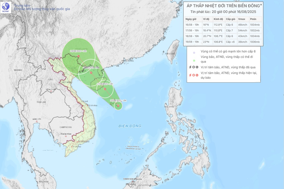
Image of the movement of the tropical depression in the East Sea tonight (August 16). Photo: nchmf
It is forecasted that in the next 24 hours, the tropical depression will move mainly in the Northwest direction at a speed of about 10-15km/h, with a slight increase in intensity.
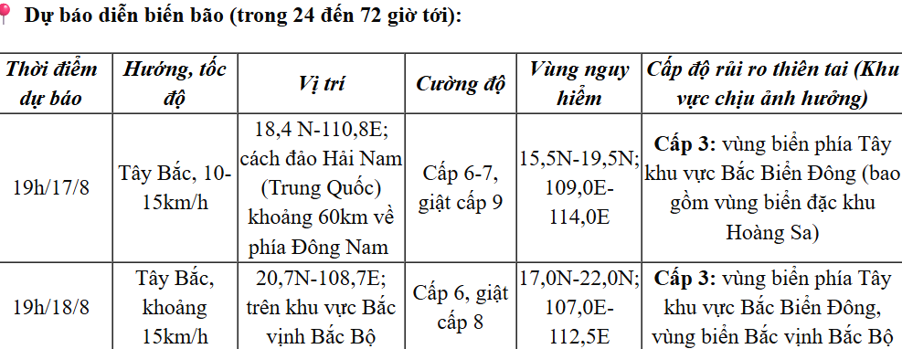
From the next 48 to 72 hours, the tropical depression will move northwest at a speed of 10-15km/h, gradually weakening in intensity.
Due to the influence of the tropical depression, the western sea area of the North East Sea (including the Hoang Sa special zone) has thunderstorms, strong winds of level 6-7, gusts of level 8-9. Waves are 2-3.5m high. The sea is rough.
In the northern Gulf of Tonkin, from the morning of August 18, the wind gradually increased to level 6, gusting to level 8. Waves were 2-3m high. Rough seas.
On land, heavy rains in some areas are still complicated. It is forecasted that from the night of August 16 to August 18, the Northeast, Thanh Hoa and Nghe An provinces will have moderate rain, heavy rain and thunderstorms with common rainfall of 50-120mm, some places will have very heavy rain over 250mm, especially in the northern mountainous areas, rain from 30-80mm, some places will have over 150mm.
On the night of August 18 and 19, the Northern region and Thanh Hoa continued to have moderate rain, heavy rain and thunderstorms, locally very heavy rain with common rainfall of 30-80mm, in some places over 150mm.
LP
Source: https://baothanhhoa.vn/tin-ap-thap-nhiet-doi-tren-bien-dong-258402.htm


![[Photo] Party and State leaders visit President Ho Chi Minh's Mausoleum and offer incense to commemorate Heroes and Martyrs](https://vphoto.vietnam.vn/thumb/402x226/vietnam/resource/IMAGE/2025/8/17/ca4f4b61522f4945b3715b12ee1ac46c)


![[Photo] General Secretary To Lam and other Party and State leaders attend the ceremony to celebrate the 80th anniversary of the Vietnam People's Public Security Forces' Traditional Day.](https://vphoto.vietnam.vn/thumb/402x226/vietnam/resource/IMAGE/2025/8/17/1f782c0c9f37400d86b29aefbd8a891b)


Comment (0)