
Latest storm news about storm number 12 (storm FENGSHEN)
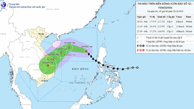
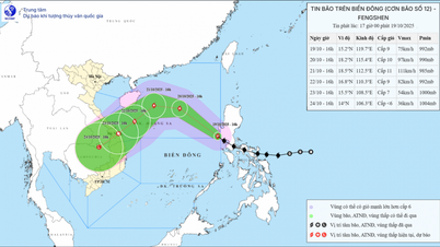
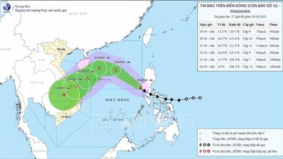
According to the latest bulletin on storm No. 12 (storm FENGSHEN) of the National Center for Hydro-Meteorological Forecasting, at 4:00 a.m. on October 20, the center of the storm was at about 17.5 degrees North latitude; 117.2 degrees East longitude, about 540km East Northeast of Hoang Sa special zone. The strongest wind near the center of the storm was level 9 (75-88km/h), gusting to level 11. The storm moved northwest at a speed of about 25km/h.
At 4:00 a.m. on October 21, storm No. 12 moved in the West-Northwest direction at a speed of about 20 km/h, about 180 km north-northeast of Hoang Sa special zone, with the possibility of strengthening. Winds near the storm center were at level 11, gusting to level 13. Disaster risk warning level 3 for the North East Sea area (including Hoang Sa special zone).

At 4:00 a.m. on October 22, storm No. 12 moved southwestward at a speed of about 10 km/h in the sea northwest of Hoang Sa special zone, with the strongest wind near the storm center at level 10-11, gusting to level 13. Warning of level 3 natural disaster risk for the western sea area of the North East Sea (including Hoang Sa special zone), and the sea area from Hue City to Quang Ngai .
At 4:00 a.m. on October 23, storm No. 12 moved southwest at a speed of about 10 km/h on the sea from Hue City to Quang Ngai. At this time, the storm is likely to weaken, with the strongest wind near the storm center at level 8, gusting to level 10. Level 3 disaster risk warning for the western sea area of the North East Sea (including Hoang Sa special zone), and the sea area from Hue City to Quang Ngai.
From the next 72 to 96 hours, the storm will move mainly in the southwest direction, about 10km per hour and gradually weaken into a low pressure area.
Warning of the impact of storm No. 12 (storm FENGSHEN)
According to the National Center for Hydro-Meteorological Forecasting, due to the impact of storm No. 12, the North East Sea area (including Hoang Sa special zone) has strong winds of level 7-8; the area near the storm's eye has strong winds of level 9-11, gusting to level 13; waves are 3.0-5.0m high, the area near the storm's eye is 5.0-7.0m high. The sea is very rough. All ships and boats operating in the above-mentioned dangerous areas are likely to be affected by storms, whirlwinds, strong winds, and big waves.
Due to the influence of storm circulation and cold air combined with easterly wind disturbances and terrain effects, from October 22-27, the area from Ha Tinh to Quang Ngai is likely to have widespread heavy rain, lasting for many days, with some areas having very heavy rain, and a high risk of flash floods and landslides in mountainous areas.
"Localities need to prepare response plans for flood scenarios on rivers from Quang Tri to Quang Ngai that could reach and exceed alert level 3. Forecast level of natural disaster risk due to floods and inundation: level 3," the National Center for Hydro-Meteorological Forecasting warned.
Warning: During October 20-22, the North East Sea area (including Hoang Sa special zone) may be affected by strong winds of level 10-11, gusts of level 13, and waves of 5.0-7.0m high. The sea will be very rough.
All ships and boats operating in the above mentioned dangerous areas are susceptible to the impact of storms, whirlwinds, strong winds and large waves.
Due to the influence of cold air combined with disturbances in the upper easterly wind zone, on the night of October 19, in the area from Nghe An to Quang Ngai, there will be moderate rain, heavy rain and thunderstorms, locally very heavy rain with rainfall of 30-60mm, some places over 100mm. Risk of heavy rain >80mm/3h. From October 20, the area will have rain, moderate rain and thunderstorms, locally heavy rain.
.jpg)
Notably, meteorological experts said that the intrusion of cold, dry air mass could weaken the storm into a tropical depression before making landfall. However, the combination of three factors: storm circulation, cold air and windward terrain of the Truong Son mountain range will cause a very heavy rain from Ha Tinh to Quang Ngai from October 23.
The specific development of this rain will depend largely on the interaction between cold air and the storm. Therefore, the authorities and people need to regularly monitor the latest weather forecasts.
Source: https://baonghean.vn/tin-bao-moi-nhat-bao-so-12-bao-fengshen-cach-hoang-sa-540km-thang-tien-vung-bien-hue-quang-ngai-dang-tang-cap-10308512.html
![[Photo] The Steering Committee of the 2025 Fall Fair checks the progress of the organization](https://vphoto.vietnam.vn/thumb/1200x675/vietnam/resource/IMAGE/2025/10/20/1760918203241_nam-5371-jpg.webp)


Comment (0)