

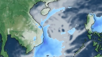
Accordingly, at 7:00 AM on October 20th, the typhoon's center was located at approximately 17.8 degrees North latitude and 116.9 degrees East longitude, about 490km east-northeast of the Hoang Sa Special Economic Zone. The strongest winds near the center of the typhoon were at level 9 (75-88 km/h), with gusts up to level 11. It was moving northwest at a speed of about 25 km/h.
Forecasts indicate that by 7:00 AM on October 21st, the storm will be approximately 180 km north of the Hoang Sa Special Economic Zone, with wind speeds of level 11, gusts of level 13, moving in a west-northwest direction at a speed of about 20 km/h, and potentially strengthening further. The affected area is the northern South China Sea (including the Hoang Sa Special Economic Zone). The level of natural disaster risk is level 3.
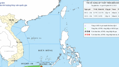
As of 7:00 AM on October 22nd, the storm was located in the sea northwest of the Hoang Sa Special Administrative Region, with wind speeds of level 10-11, gusts up to level 13, moving southwest at a speed of approximately 10 km/h. The affected area is the sea west of the North East Sea (including the Hoang Sa Special Administrative Region), and the sea area from Hue City to Quang Ngai . The level of natural disaster risk is level 3.
As of 7:00 AM on October 23rd, the storm in the sea area from Hue City to Quang Ngai Province had wind speeds of level 8, gusting to level 10, moving southwest at a speed of approximately 10 km/h and likely to weaken. The affected area is the western sea area of the North East Sea (including the Hoang Sa Special Economic Zone), and the sea area from Hue City to Quang Ngai Province. The level of natural disaster risk is level 3.
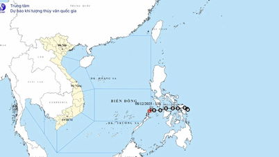
Over the next 72 to 96 hours, the storm moved mainly southwest, traveling at approximately 10 km per hour and gradually weakening into a low-pressure area.
Due to the impact of the storm, the northern South China Sea area (including the Hoang Sa Special Administrative Region) will experience strong winds of force 7-8; winds near the storm's center will reach force 9-11, with gusts up to force 13; sea waves will be 3-5m high, and 5-7m high near the storm's center. The sea will be extremely rough.
All ships and boats operating in the aforementioned hazardous areas are susceptible to the effects of thunderstorms, tornadoes, strong winds, and large waves.
On land, due to the influence of the storm circulation and cold air combined with easterly wind disturbances and topographic effects, from approximately October 22nd to 27th, the area from Ha Tinh to Quang Ngai is highly likely to experience widespread, prolonged heavy rainfall, with localized areas experiencing very heavy rain. There is a high risk of flash floods and landslides in mountainous areas, and flooding in low-lying areas and urban areas. Local authorities need to be prepared with response plans for flood scenarios on rivers from Quang Tri to Quang Ngai, which may reach or exceed alarm level 3. The forecast indicates a level 3 natural disaster risk due to floods and inundation.
Source: https://baotintuc.vn/xa-hoi/anh-huong-bao-so-12-bac-bien-dong-gio-giat-manh-song-cao-20251020084314263.htm


Comment (0)