

According to Mr. Nguyen Van Huong, individuals, independent experts or Facebookers, TikTokers have contributed to spreading social attention to the topic of climate change response and natural disaster risks. Natural disasters are currently tending to develop more and more abnormally and extremely. Each source of information, if analyzed on a scientific , objective basis and carefully verified, has a certain value in helping people raise their vigilance and proactively respond.
However, in forecasting and warning, scientific assessments need to be built on the basis of a system of monitoring data, calculation models and verified technical processes, ensuring accuracy and consistency according to the standards of the World Meteorological Organization (WMO). The Department of Hydrometeorology is the agency primarily responsible for issuing forecast and warning bulletins to serve the direction and management of the Government, ministries, branches and localities.
The hydrometeorological agency is ready to cooperate, share data and exchange expertise with scientists inside and outside the forecasting agency to bring forecast and warning information closer and faster to the community, towards the common goal of minimizing damage caused by natural disasters and ensuring safety for people.
People can follow forecast information from the following sources: Information portal of the General Department of Hydrometeorology; National Center for Hydrometeorological Forecasting at: nchmf.gov.vn; information page of local Hydrometeorological Station as well as central and local press and television agencies.
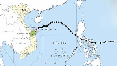
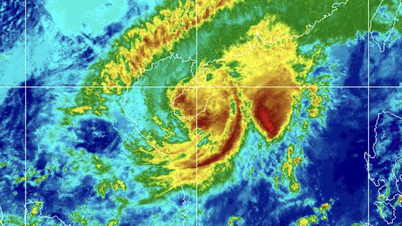
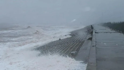
Providing more information about the rain situation when storm No. 12 weakened into a tropical depression and then a low pressure area and dissipated right at sea, Mr. Nguyen Van Huong said that this rain shows the complexity in the interaction between atmospheric systems, especially between the circulation of storm No. 12 and the strong cold air mass from the North. Initial forecasts are inclined towards the scenario of the storm moving steadily, towards the sea area of Hue - Da Nang city in the afternoon of October 22 with an intensity weakening only 1-2 levels compared to when it was still at sea. Accordingly, the storm circulation when making landfall still carries a large amount of moisture from the sea to the mainland, causing rain in the Central region.
However, in reality, after reaching the Hoang Sa special zone, the storm changed direction to the southwest and slowed down a lot, only about 5-10 km/h. Because the storm circulation was affected by a strong, dry cold air mass, the storm weakened too quickly and dissipated right at sea. Therefore, the rain caused by the storm circulation was no longer as heavy as initially expected.
During the night of October 22 and the morning of October 23, the area from Ha Tinh to Da Nang city had moderate rain, heavy rain, and some places had very heavy rain. The rainfall from 7:00 p.m. on October 22 to 8:00 a.m. on October 23 was locally over 80mm in some places such as: Ho Mac Khe station (Ha Tinh) 149.6mm, Truong Xuan station (Quang Tri) 89.2mm, Bach Ma National Park station (Hue city) 108mm,...
This is just the beginning of this long and complicated rain period. After the storm dissipates, the East wind disturbance, cold air and wind-blocking terrain will cause very heavy rain, lasting for many days, with the possibility of rain increasing from the evening of October 23.
"People should not be subjective; the risk of flash floods, landslides and deep flooding in low-lying areas is still being warned by the Hydrometeorological Agency in the coming days and is being closely monitored, and will continuously update bulletins so that localities can proactively respond," Mr. Nguyen Van Huong noted.
Source: https://baotintuc.vn/van-de-quan-tam/trung-tam-du-bao-khi-tuong-thuy-van-quoc-gia-khuyen-cao-nguoi-dan-chon-loc-nguon-tin-du-bao-thoi-tiet-20251023124717264.htm
![[Photo] President Luong Cuong holds talks with South African President Matamela Cyril Ramaphosa](https://vphoto.vietnam.vn/thumb/1200x675/vietnam/resource/IMAGE/2025/10/23/1761221878741_ndo_br_1-8416-jpg.webp)

![[Photo] Prime Minister Pham Minh Chinh meets with South African President Matamela Cyril Ramaphosa](https://vphoto.vietnam.vn/thumb/1200x675/vietnam/resource/IMAGE/2025/10/23/1761226081024_dsc-9845-jpg.webp)
![[Photo] Prime Minister Pham Minh Chinh chairs meeting on railway projects](https://vphoto.vietnam.vn/thumb/1200x675/vietnam/resource/IMAGE/2025/10/23/1761206277171_dsc-9703-jpg.webp)


Comment (0)