
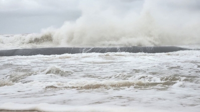
On the afternoon of October 22, the National Center for Hydro-Meteorological Forecasting issued a warning: a tropical depression is appearing in the sea east of Taiwan (China).
At 4 p.m. the same day, the center of the tropical depression was at about 22.7 degrees North latitude and 123.3 degrees East longitude. The strongest wind near the center of the tropical depression reached level 7 (50-61 km/h), gusting to level 9. This tropical depression is currently moving southwest at a speed of 20-25 km/h.

The tropical depression is moving at a fast speed. In the next 24 to 48 hours, the tropical depression will move in the South-Southwest and South-West direction at a speed of 20-25km/hour.
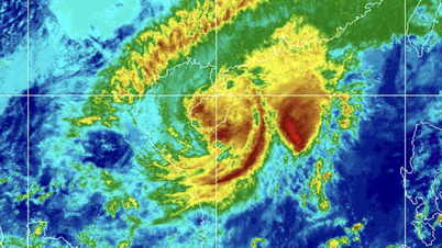
The National Center for Hydro-Meteorological Forecasting said that by 4 p.m. tomorrow, October 23, the center of the tropical depression will be located in the eastern sea of the North East Sea. The strongest wind near the center will reach level 6-7, gusting to level 9. From the afternoon of October 23 to October 24, the tropical depression will move southwest at a speed of about 20-25 km/hour but will tend to weaken gradually.
At about 4 p.m. on October 24, the center of the tropical depression was at about 15.6 degrees North latitude and 115.5 degrees East longitude, about 350km east of the Hoang Sa archipelago (special zone). Wind intensity decreased to level 6, gusting to level 8.
During the next 48 to 72 hours, the tropical depression will continue to move mainly in the West Southwest direction, traveling 15-20km per hour and gradually weaken into a low pressure area.
Source: https://www.sggp.org.vn/xuat-hien-ap-thap-nhiet-doi-moi-huong-vao-khu-vuc-bac-bien-dong-post819393.html

![[Photo] Prime Minister Pham Minh Chinh chairs meeting on nuclear power plant construction](https://vphoto.vietnam.vn/thumb/1200x675/vietnam/resource/IMAGE/2025/10/22/1761137852450_dsc-9299-jpg.webp)
![[Photo] Da Nang: Shock forces protect people's lives and property from natural disasters](https://vphoto.vietnam.vn/thumb/1200x675/vietnam/resource/IMAGE/2025/10/22/1761145662726_ndo_tr_z7144555003331-7912dd3d47479764c3df11043a705f22-3095-jpg.webp)


Comment (0)