
Low pressure strengthens into tropical depression
According to the National Center for Hydro-Meteorological Forecasting, on the evening of August 16, the low pressure area in the sea south of Hoang Sa special zone strengthened into a tropical depression.
At 7:00 p.m., the center of the tropical depression was at about 16 degrees North latitude; 112.8 degrees East longitude. The strongest wind near the center of the tropical depression was level 6 (39-49 km/h), gusting to level 8; moving northwest at a speed of about 10 km/h.
At 7:00 p.m. on August 17, the tropical depression was about 60km southeast of Hainan Island (China) with strong winds of level 6-7, gusting to level 9; moving northwest at a speed of 10-15km/h.
The affected area is the western sea area of the North East Sea (including the Hoang Sa special zone). Disaster risk level 3.
At 7:00 p.m. on August 18, the tropical depression in the northern Gulf of Tonkin with strong winds of level 6, gusts of level 8, moved northwest at a speed of about 15km/h.
The affected area is the western sea area of the North East Sea and the northern sea area of the Gulf of Tonkin. Disaster risk level 3.
From the next 48 to 72 hours, the tropical depression will move northwest at a speed of 10-15km/h, gradually weakening in intensity.
Due to the impact of the tropical depression, the western sea area of the North East Sea (including the Hoang Sa special zone) has thunderstorms and strong winds of level 6-7, gusts of level 8-9, waves 2-3.5m high, and rough seas.
From the morning of August 18, the northern sea area of Bac Bo Gulf has gradually increased in wind to level 6, gusting to level 8, waves 2-3m high, rough seas.
Ships operating in the above mentioned dangerous areas are likely to be affected by storms, whirlwinds, strong winds and large waves.
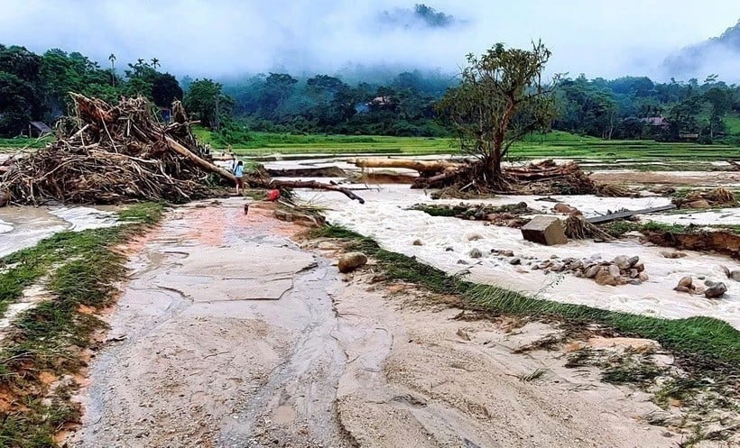
Risk of flash floods and landslides at night and early morning in 8 Northern provinces
According to the National Center for Hydro-Meteorological Forecasting, from 9:40 p.m. on August 16 to 2:40 a.m. on August 17, the northern provinces will continue to have rain with accumulated rainfall ranging from 20-40mm, with some places over 70mm.
Risk of flash floods on small rivers and streams, landslides on steep slopes in many communes/wards: Chieng Hac, Chieng Hoa, Long Phieng, Muong Bu, Muong Coi, Muong Gion, Ngoc Chien, Phieng Khoai ( Son La province);
Luong Son, Lien Son, Ky Son ward, Quy Duc, Thinh Minh; Cu Dong, Da Bac, Lac Thuy, Mai Chau, Mai Ha, Muong Dong, Ngoc Son, Son Luong, Tan Mai, Tien Luong, Tu Vu, Van Lang, Van Son, Yen Son ( Phu Tho province);
Dong Cuong, Hung Khanh, Luong Thinh, Mo Vang, Nam Co, Au Lau, Van Phu, Phinh Ho, Phong Du Thuong, Quy Mong, Son Luong, Ta Xi Lang, Tan Hop, Tang Loong, Tran Yen, Tu Le, Van Chan, Vo Lao, Xuan Ai ( Lao Cai province);
Lung Phin, Sa Phin, Sung Mang; Bach Dich, Dong Van, Du Gia, Ho Thau, Khuon Lung, Lao Chai, Linh Ho, Meo Vac, Na Hang, Nghia Thuan, Ha Giang 1, Ha Giang 2, Pho Bang, Quan Ba, Thang Mo, Thanh Thuy, Tien Nguyen, Tung Vai, Yen Minh (Tuyen Quang province);
Nam Cuong, Phuc Loc, Quang Bach (Thai Nguyen province); Bao Lam, Xuan Truong, Yen Tho (Cao Bang province); Chi Lang, Nhan Ly, Quan Son (Lang Son province);
Van Don Special Zone; Co To Special Zone, Dam Ha; Duong Hoa, Cam Pha, Cua Ong, Mong Duong, Quang Hanh, Quang Tan (Quang Ninh province).
Flash floods and landslides can have very negative impacts on the environment, threaten people's lives; cause local traffic congestion, affect the movement of vehicles; destroy civil and economic works, causing damage to production and socio-economic activities.
The Hydrometeorological Agency recommends that local authorities pay attention to reviewing bottlenecks and vulnerable locations in the area to take preventive and response measures.
From 8:00 p.m. on August 15 to 8:00 p.m. on August 16, the provinces in the Northern region had moderate to heavy rain, and in some places very heavy rain such as: Muong Gion (Son La) 66.2mm; Doc Kem (Phu Tho) 193.7mm; Dai Son2 (Lao Cai) 83.4mm; Phuong Do (Tuyen Quang) 78.2mm; Quang Bach (Thai Nguyen) 58mm, Mong An2 (Cao Bang) 50.4mm; Chi Lang (Lang Son) 74.6mm; Ban Sen (Quang Ninh) 204.7mm...
Soil moisture models show that some areas in the above provinces are nearly saturated (over 85%) or have reached saturation./.
Source: https://baolangson.vn/ap-thap-manh-len-thanh-ap-thap-nhiet-doi-nguy-co-lu-quet-o-mien-nui-bac-bo-5056257.html


![[Photo] Party and State leaders visit President Ho Chi Minh's Mausoleum and offer incense to commemorate Heroes and Martyrs](https://vphoto.vietnam.vn/thumb/402x226/vietnam/resource/IMAGE/2025/8/17/ca4f4b61522f4945b3715b12ee1ac46c)


![[Photo] General Secretary To Lam and other Party and State leaders attend the ceremony to celebrate the 80th anniversary of the Vietnam People's Public Security Forces' Traditional Day.](https://vphoto.vietnam.vn/thumb/402x226/vietnam/resource/IMAGE/2025/8/17/1f782c0c9f37400d86b29aefbd8a891b)


Comment (0)