
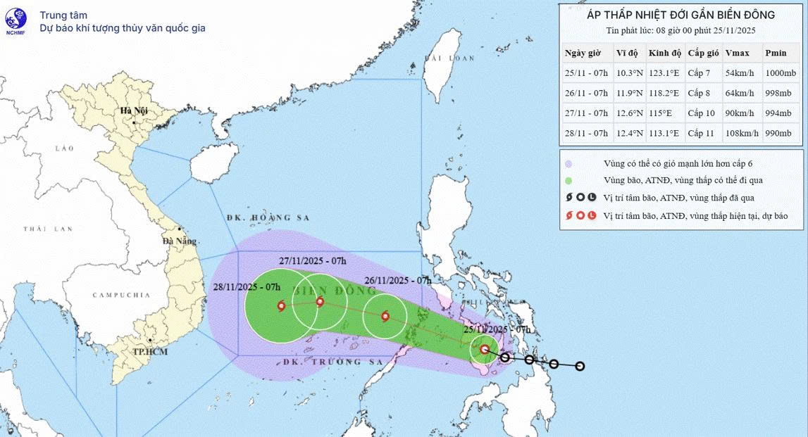
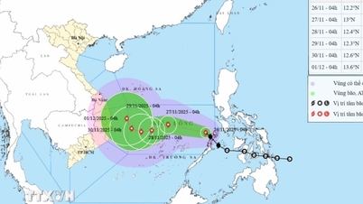
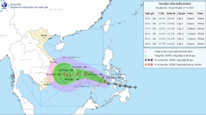
Current status of tropical depression
At 7:00 a.m. this morning (November 25), the center of the tropical depression was determined to be at about 10.3 degrees North latitude; 123.1 degrees East longitude, in the central region of the Philippines. The strongest wind near the center reached level 7 (50-61 km/h), gusting to level 9, moving in the West Northwest direction at a speed of 20-25 km/h.
Forecast of tropical depression/storm development (in the next 24-48 hours)
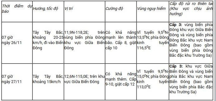
In the next 24-48 hours, the tropical depression is likely to strengthen into a storm and continue moving west-northwest.
In the next 48-72 hours, the storm is forecast to move mainly in a westerly direction, at a speed of 10-15 km/hour and is likely to strengthen.
Forecasting the impact of tropical depressions/storms
At sea : From the evening of November 25, the eastern area between the East Sea and the northeastern sea of the South East Sea will experience winds gradually increasing to level 6-7; near the storm center, winds will be level 8-9, gusting to level 11. Waves will be 3-5 m high, and the sea will be very rough.
Warning: From November 26-28, the area between the East Sea and the northern waters of the South East Sea (including the northern waters of the Truong Sa archipelago) may be affected by strong winds of level 10-11, gusting to level 14.
Vessels operating in the above mentioned sea areas should pay special attention to the risk of storms, whirlwinds, strong winds and large waves.
Source: https://baolaocai.vn/ap-thap-nhiet-doi-co-kha-nang-manh-len-thanh-bao-khi-vao-bien-dong-post887528.html

![[Photo] Close-up of heavy damage at the school located on the banks of the Ban Thach River](/_next/image?url=https%3A%2F%2Fvphoto.vietnam.vn%2Fthumb%2F1200x675%2Fvietnam%2Fresource%2FIMAGE%2F2025%2F11%2F26%2F1764152130492_ndo_bl_img-8188-8805-jpg.webp&w=3840&q=75)


![[Photo] Opening of the 28th Session of the Hanoi People's Council](https://vphoto.vietnam.vn/thumb/402x226/vietnam/resource/IMAGE/2025/11/26/1764155991133_image.jpeg)


Comment (0)