
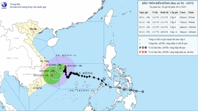
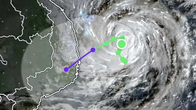
The National Center for Hydro-Meteorological Forecasting said that within the next 24 hours, storm Koto will change direction to the southwest and head towards the Gia Lai - Dak Lak mainland, continuing to weaken into a tropical depression. It is forecasted that at around 4am on December 2, the tropical depression will be about 170km east of the Gia Lai - Dak Lak coast.

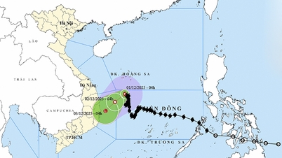
Storm Koto is forecast to weaken into a tropical depression and dissipate at sea in the next 1-2 days. Photo: NCHMF .
The storm/tropical depression area has strong winds of level 6; the area near the storm's center has strong winds of level 7-8, gusting to level 10; waves 2-6m high; rough seas. Ships operating in the above-mentioned dangerous areas are likely to be affected by storms, whirlwinds, strong winds, and large waves.
By December 3, the tropical depression is likely to dissipate over the Gia Lai - Khanh Hoa sea area.

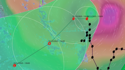
The storm is forecast to continue causing strong winds and large waves on December 1. Photo: NCHMF .
Regarding the weather on land, on December 1-2, the North and North Central regions are forecast to have fog in the early morning and sunny during the day. Humidity will increase compared to previous days. The night and morning will be cold, with some areas in the mountainous areas of the North being very cold. High mountainous areas should be on guard against the possibility of frost and frost.
Other areas will have scattered showers and thunderstorms. From December 2, the South Central Coast, Central Highlands and Southern regions will have scattered showers and thunderstorms, with some heavy rain in some places. The Central Highlands will have cold mornings and nights; other areas will have cold mornings and nights. People should be on guard against thunderstorms with the possibility of tornadoes, lightning and strong gusts of wind.
Source: https://nongnghiepmoitruong.vn/bao-koto-giam-xuong-cap-8-be-lai-huong-vao-dat-lien-d787430.html


Comment (0)