
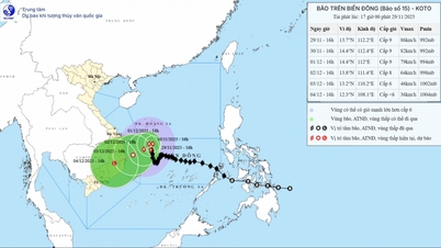
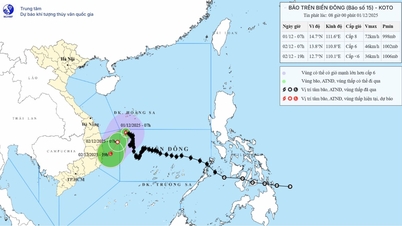
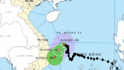
By 4:00 a.m. on December 2, the storm center had moved down to 13.8 degrees North latitude, 110.9 degrees East longitude and about 170 km east of the eastern coast of Gia Lai - Dak Lak provinces. The storm's intensity has significantly weakened, to only level 6, gusting to level 8, changing direction to move southwest at a speed of about 5 km/h. It is forecasted that by 4:00 a.m. on December 3, the storm will continue to weaken into a low pressure area over the sea from Gia Lai to Khanh Hoa, with wind near the center decreasing to below level 6.

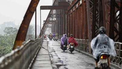
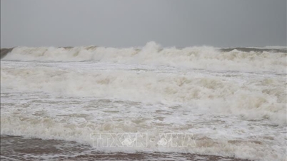
Field records show that strong winds have appeared at a number of monitoring stations. On Ly Son Island in the early morning of December 1, there was a strong northeast wind of level 5, sometimes level 6, gusting to level 7. At sea, the danger zone due to the storm circulation continued to expand. During the day and night of December 1, the northwest sea area of the central East Sea had strong winds of level 6; the area near the storm's eye had strong winds of level 7-8, gusting to level 10, waves 2-4 m high, especially near the storm's eye up to 4-6 m, rough seas.
The sea area from Quang Ngai to Khanh Hoa also recorded strong winds of level 6, gusting to level 7-8; waves of 2-4 m high, posing a danger to ships operating far from shore. It is forecasted that in the coming time, the sea area in the west of the central East Sea, the south of the northern East Sea (including the Hoang Sa sea area) and the sea area from Gia Lai to Khanh Hoa will continue to have scattered showers and thunderstorms. Particularly, the northwest of the central East Sea area will have storms, with the risk of tornadoes and strong gusts of wind.
The meteorological agency warned that vessels operating in the above-mentioned sea areas should regularly update forecast information; proactively avoid dangerous areas, and be on guard against storms, whirlwinds, strong winds and large waves in the coming days as the storm continues to weaken but circulation still causes widespread bad weather.
Weather forecast for regions across the country:
Hanoi capital is cloudy, with rain in some places, early morning fog in some places, sunny in the afternoon. Light wind. Cold in the morning and at night. Lowest temperature 18-20 degrees Celsius. Highest temperature 24-26 degrees Celsius.
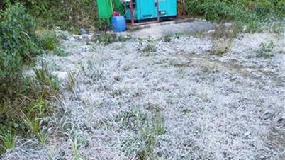
The Northwestern provinces are cloudy, sunny during the day, no rain at night, some places have fog in the early morning. Light wind. Cold in the morning and at night, some places are very cold. High mountains should be on guard for the possibility of frost and ice. Lowest temperature 13-16 degrees Celsius, some places below 10 degrees Celsius. Highest temperature 23-26 degrees Celsius, some places above 26 degrees Celsius.
The Northeastern region is cloudy, with rain in some places, fog in some places in the early morning, sunny in the afternoon. Light wind. Cold in the morning and at night, some places in the mountains are very cold. The lowest temperature is 17-20 degrees Celsius, in the mountains 13-16 degrees Celsius, in the high mountains some places are below 10 degrees Celsius. The highest temperature is 23-26 degrees Celsius, some places are above 26 degrees Celsius.
Provinces from Thanh Hoa to Hue have clouds, sunny days, some rain at night, some fog in the early morning. North to northwest wind level 2-3. In the North, early morning and night is cold, in the South it is cold. Lowest temperature 18-21 degrees Celsius. Highest temperature 23-26 degrees Celsius.
South Central Coast: Cloudy, scattered showers and thunderstorms. Northeast to north wind level 3. During thunderstorms, there is a possibility of tornadoes, lightning and strong gusts. Cold at night and early morning. Lowest temperature 22-25 degrees Celsius. Highest temperature 26-29 degrees Celsius, in the South 29-32 degrees Celsius.
Central Highlands: Cloudy, scattered showers and thunderstorms. Northeast wind level 2-3. There is a possibility of tornadoes, lightning and strong gusts during thunderstorms. Lowest temperature 19-22 degrees Celsius, below 19 degrees Celsius in some places. Highest temperature 28-31 degrees Celsius.
The South is cloudy, sunny in the afternoon, showers and thunderstorms in some places in the evening and at night. Northeast wind level 2-3. Lowest temperature 22-25 degrees Celsius. Highest temperature 30-33 degrees Celsius, some places above 33 degrees Celsius.
Ho Chi Minh City is cloudy, sunny during the day, no rain at night. Light wind. Lowest temperature 23-25 degrees Celsius. Highest temperature 31-33 degrees Celsius.
Source: https://baotintuc.vn/xa-hoi/thoi-tiet-ngay-112-bao-so-15-suy-yeu-dan-canh-bao-song-lon-va-gio-manh-20251201060956647.htm


![[Photo] Dan Mountain Ginseng, a precious gift from nature to Kinh Bac land](/_next/image?url=https%3A%2F%2Fvphoto.vietnam.vn%2Fthumb%2F1200x675%2Fvietnam%2Fresource%2FIMAGE%2F2025%2F11%2F30%2F1764493588163_ndo_br_anh-longform-jpg.webp&w=3840&q=75)


Comment (0)